Storm cancels Bucks County school activities as wind, flooding expected
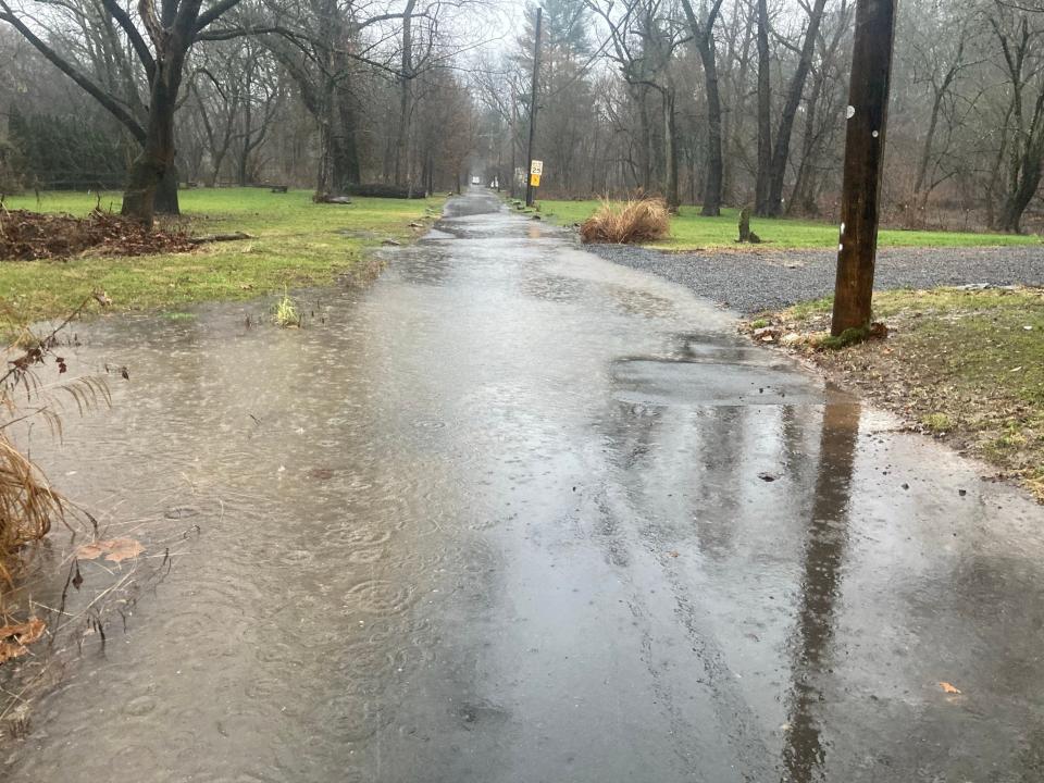
The National Weather Service is warning a potent system will hit Bucks County on Tuesday afternoon, raising the chances of flooding along the Neshaminy Creek and bringing heavy winds that could cause trouble.
Emergency management officials are urgining caution into Tuesday night as the storm strengthens and ask residents to prepare. Many Bucks County schools have canceled activities ahead of the storm.
The weather service updated its forecast on Tuesday morning.

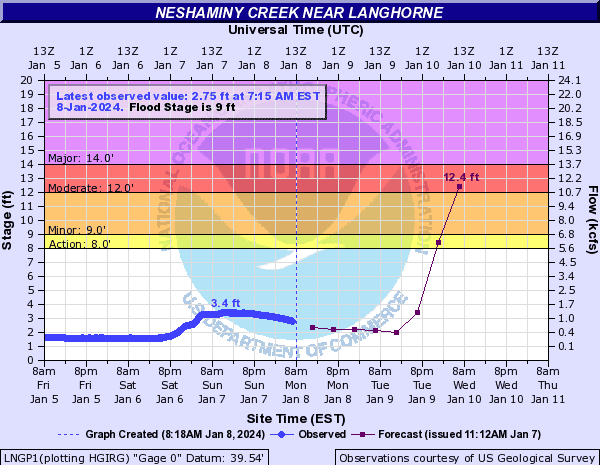
"For the Neshaminy Creek at Langhorne, we are expecting moderate flooding in that area," said Joe DeSilva, meteorologist with the National Weather Service in Mount Holly. "The Delaware River at Trenton, we are not even forecasting for it to get into even the minor flood stage.
"The rain will start to move in and become more intense later Tuesday afternoon, and basically continue until about 1, 2 in the morning before it dies out rather quickly as a cold front moves through."
The Neshaminy Creek at Langhorne floods at 9 feet, and by Wednesday morning, the creek could rise to over 12 feet, which is considered moderate flooding.
The Delaware River at Trenton's flood stage is 20 feet, and the weather service expects the Delaware River at Trenton to reach 12.8 feet on Wednesday.
More: Winter storm brings heavy rain, high winds and flooding across Bucks County
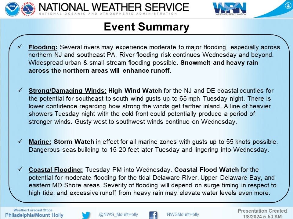
The impending storm, along with runoff from this past weekend's storm, has caused the weather service to update its a flood watch, and warning of flooding on the Neshaminy Creek in Hulmeville and Middletown.
"Major coastal flooding possible for upper portions of the Chesapeake Bay with high tide tonight," read a portion of the alert. "Coastal Flood Warning now in effect for Ocean County for high tide cycles tonight through Wednesday morning."
The storm is expected to run through at least Wednesday and drop several inches of rain on Bucks County.
Bucks County school districts cancel activities ahead of storm
Due to the storm, the Bensalem School District is closing 30 minutes early on Tuesday, and canceling all after-school and evening activities. Bristol Borough School District is canceling all after-school activities.
Council Rock School District will cancel all after-school and evening activities both for the school and community, with the exception of Champions after-school care.
Morrisville School District will cancel all after-school activities and close the high school building to students and staff at 2:45 p.m. and the elementary and intermediate building at 3:15 p.m.
Neshaminy School District will cancel all after-school activities. The school board meeting Tuesday evening is still scheduled.
Pennsbury School District will cancel all after-school activities with the exception of Kids Care, which currently will remain open. Centennial School District is also canceling all after-school activities.
🌧️ Brace yourselves for some rain in the forecast.
The ground is already saturated, and with melting snow, there's a risk of potential flooding. There's also a chance of power outages for an extended period.
Here's what you can do to stay ahead of the game: ⬇️⬇️⬇️ pic.twitter.com/bTjIZKIPWm— Bucks County Government (@BucksCountyGovt) January 9, 2024
Tuesday morning, Central Bucks School District notified parents that all after-school activities are cancelled, and aftercare programs will close early at 5 p.m. The school board has rescheduled its monthly meeting for Thursday Jan. 11 as a precaution. The meeting will be held at 7 p.m. at the Welden Drive building in Doylestown.
In Pennridge, an early dismissal was issued for all schools. Dismissal times can be found at pennridge.org.
Quakertown Community School District is dismissing schools early. Dismissal times can be found at qcsd.org. On its website, district officials noted that a decision on a possible late arrival for Wednesday will be determined later with a separate notification sent out.
Early dismissal was also issued in Palisades, and all after-school activities have been cancelled. Dismissal times can be found at palisd.org.
All campuses and facilities of Bucks County Community College will close at 1 p.m. Tuesday and all evening activities are canceled, the college said. On Wednesday, the college will operate on a two-hour delay.
Superintendents from school districts around the county met with county emergency management officials Tuesday and most have already announced two-hour delayed opening for Wednesday.
Bucks County says take weather precautions
Bucks County Administration issued an alert on X, the social media platform formerly referred to as Twitter, to update Bucks County residents on the rainy conditions.
Bucks County administered also provided steps resident should take in preparation:
Prepare for Flooding: Take extra precautions near creeks and rivers, or if you're in an area that has recently flooded.
Prepare Your Home: Clear gutters, check for any drainage issues, and secure loose items.
Power Up Your Electronics: Charge phones, tablets, laptops - and consider investing in extra battery packs. Stay connected even if the power goes out!
Emergency Kit Check: Is your emergency kit fully stocked? Nows the time to ensure it's loaded with essentials - non-perishable food, water, flashlights, batteries, and important documents.
Evacuation Plan: If you need to evacuate, listen to emergency responders and local officials. Have all important documents gathered and easy to grab if needed.
Stay Informed: Keep an eye on local weather updates and alerts. Knowledge is key to staying safe during unpredictable weather.
Lower Makefield issues advisory for midweek storm
Lower Makefield administration also warned its residents of the coming storm via a post on its website.
The township will open its Emergency Operations Center at 6 p.m. and is advising people to secure anything loose around their homes as winds could reach 55 mph. Anyone with a storm-related issue or concern should call the center at 215-493-4055.
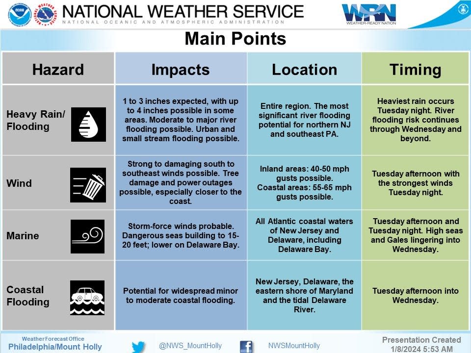
"Heavy rainfall is possible across our entire area with rainfall amounts of 2 to 3 inches is possible," read a portion of the alert. "This may lead to areas of flooding, including potential for main stem river flooding. Strong to locally damaging winds are possible which may result in downed trees and power lines and power outages.
"Lower Makefield Police & Emergency Management Personnel ask that all residents avoid traveling during these storms if possible. In the event of an emergency, please contact 911 immediately. For non-emergencies, please call 215-493-4011."
Ahead of the storm, the Pennsylvania Department of Transportation, the state Emergency Management Agency (PEMA) and the Pennsylvania Turnpike Commission have jointly advised motorists to stay home and off the roads if possible. Speed restrictions will be put into effect on some sections of the turnpike and other roads during the storm.
“This will be a challenging event with rapidly changing conditions, and we ask the public to avoid unnecessary travel if possible," said said PennDOT Secretary Mike Carroll. "If you must travel, please exercise caution, check 511PA.com for the latest conditions, and give our crews space to safely and effectively respond to the storm.”
PEMA Director Randy Padfield said anyone can sign up for free alerts so they are notified when weather watches and warnings are issued for their area.
Several inches of snow, rainfall in Bucks County raise water levels of Neshaminy Creek, Delaware River
Mike Lee, another meteorologist with the National Weather Service in Mount Holly, said residents near Neshaminy Creek should prepare for any flooding to come.
Indoor golfing in Doylestown: Get ready to tee off. Indoor golf lounge opening in Doylestown — and it's BYOB
"Beginning Tuesday afternoon and into the evening, there will be heavy rainfall," Lee said. "At that point, around 8 a.m. Wednesday, we expect the Neshaminy Creek to at least be at the moderate flood stage.
"There will be fairly moderate impact for folks living across the creek."
Snow storm moved out quickly but left rain for hours in Bucks County
Lee said Bucks County received some snow on Satruday before the system generally switched over to rain over the weekend.
"East Rockhill Township received 2.5 inches of snow, while Doylestown and New Hope received about 2 inches," Lee said. "There were some other locations, but they all received less than 1 inch of snow.
"In terms of rainfall, Bucks County generally received anywhere between .75 and 1 inch of rain," Lee added. "The highest amount of rain was in Kintnersville, which received 1.02 inches of rain."
The National Weather Service expects between 1 to 3 inches of rainfall, according to its alerts.
"The ground remains very saturated following multiple rounds of heavy rainfall over the last month," read the weather service's flood watch notice. "A period of higher hourly rainfall rates is possible during Tuesday night which would enhance the potential for flooding, particularly in the urban areas.
"Tidal inundation combined with runoff in coastal areas may significantly elevate the flood risk, especially if occurring during times of high tide."
The full forecast from the National Weather Service indicates a one-day lull before the next storm:
Monday: Sunny, with a high near 41. Northwest wind 5 to 10 mph.
Monday overnight: Increasing clouds, with a low around 27. West wind around 5 mph becoming calm.
Tuesday: Rain, mainly after 10 a.m. High near 49. East wind 5 to 15 mph. Chance of precipitation is 90%. New precipitation amounts between 0.75 and 1 inch possible.
Tuesday overnight: Rain. The rain could be heavy at times. Low around 46. Breezy, with a southeast wind 20 to 25 mph becoming southwest after midnight. Winds could gust as high as 40 mph. Chance of precipitation is 100%. New precipitation amounts between 1 and 2 inches possible.
Wednesday: Rain likely before 7 a.m., then a slight chance of showers between 7 a.m. and 1 p.m. Partly sunny, with a high near 49. Breezy, with a southwest wind 15 to 25 mph, with gusts as high as 35 mph. Chance of precipitation is 60%. New precipitation amounts of less than a tenth of an inch possible.
Wednesday overnight: Partly cloudy, with a low around 32. Breezy.
Thursday: Sunny, with a high near 48.
Thursday overnight: Mostly clear, with a low around 30.
Friday: A chance of rain after 1 p.m. Partly sunny, with a high near 48. Chance of precipitation is 30%.
Friday overnight: Rain. Low around 38. Breezy. Chance of precipitation is 80%.
Tips to protect your car this winter: Tips and tricks on how to prepare your car for the cold Bucks County winter ahead
This article originally appeared on Bucks County Courier Times: Bucks County storm: Rain, wind, flooding expected on Neshaminy Creek

