Newfoundland sees more snow as nor'easter continues winter wallop
Delays, cancellations and closures ensued across Atlantic Canada as a potent nor'easter barrelled through Tuesday and Wednesday.
The storm could bring the biggest snowfall of the season for some communities, with some Nova Scotia centres tallying up hefty accumulations as of Wednesday morning local time. Shelburne had seen 37 cm and Halifax Stanfield Airport reported 29 cm, with as much as 35 cm documented in the Halifax area.
RELATED: PHOTOS: Snow piling up quickly as intense nor'easter batters Atlantic Canada
The good news for the Maritimes is the worst of the storm is over, with Newfoundland dealing with lingering effects on Thursday.
The majority of winter storm warnings have been dropped in Nova Scotia, other than Cape Breton, while the the rest are in effect in Newfoundland.
Here is what is left to come of the storm.
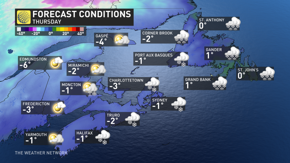
Wednesday night and Thursday impacts in Newfoundland
Snow developed for the Avalon Peninsula through Wednesday and picked up in intensity pretty quickly. Nearly 20 cm fell in St. John’s by Wednesday evening, with more still to come through the overnight period and Thursday.

Periods of blizzard conditions and nearly half a metre of snow is forecast for the entire event through Thursday in Newfoundland, especially near Gander.
Through the two-day event, 30-50+ cm is possible for northeastern Newfoundland and along the Trans-Canada Highway. Travel is highly advised against.
BEWARE: Towering snow piles could lead to very expensive problems you didn't see coming
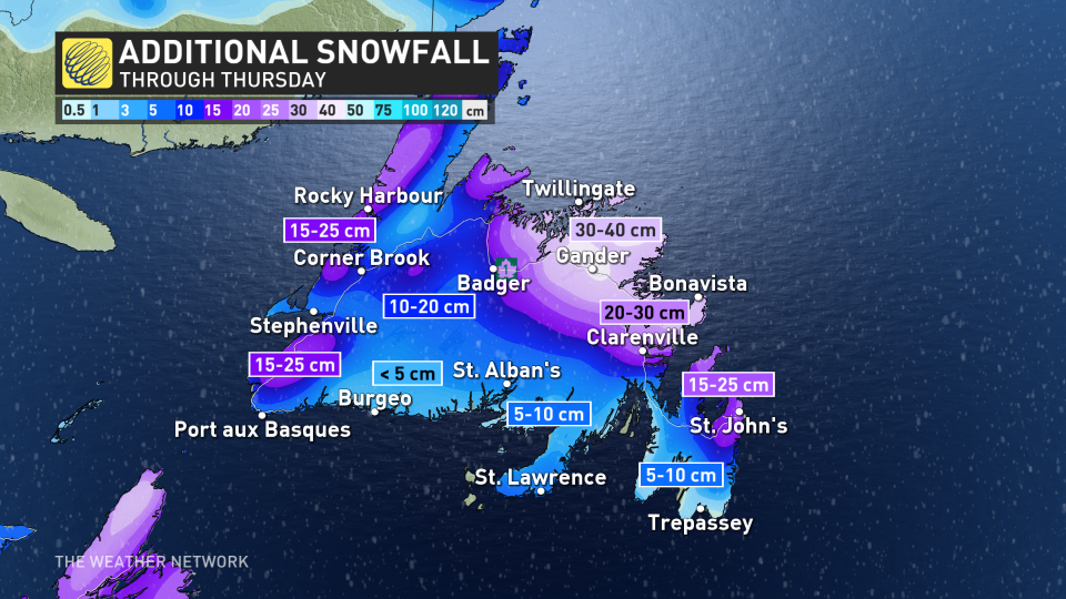
Regions along the southern coast will begin to see improving snow conditions by Thursday afternoon with less than 5 cm forecast. However, periods of blowing snow and gusty winds will persist.
Heavy snowfall is likely to continue for the northern coast of the island, paired with wind gusts of 60-80 km/h, which will create continued dangerous conditions.
Near-zero visibility and blizzard conditions are expected southeast of Gander, including St. John’s.
For Thursday, an additional 15-25 cm is expected for St. John’s, 20-30 cm for the Bonavista and 30-40 cm still to come in Gander.
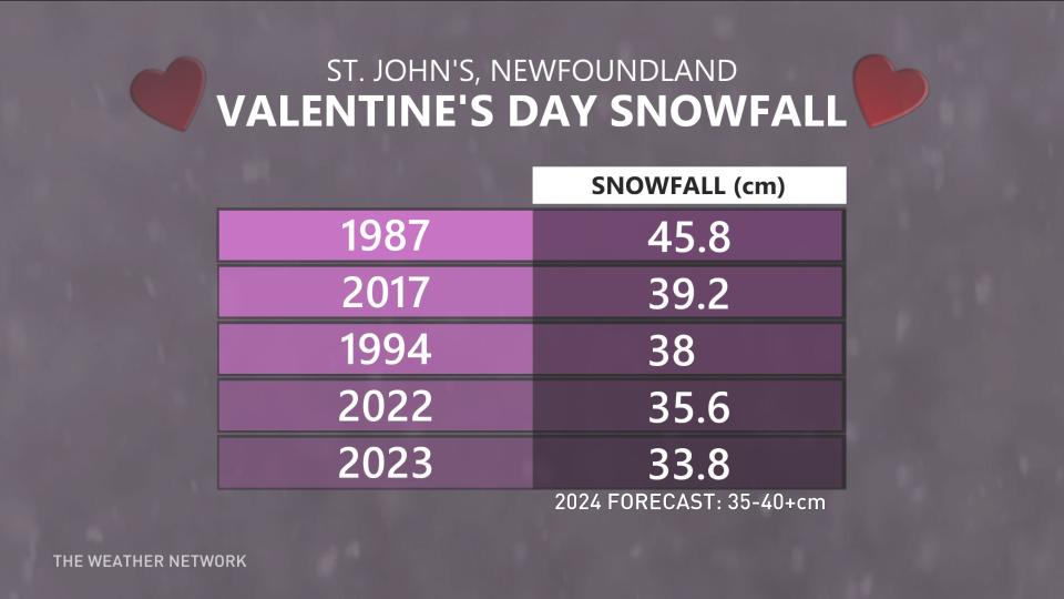
This will likely be the biggest snowfall of the entire season for St. John’s, with the previous high occurring on Jan. 5, 2024 with 23 cm of daily snowfall.
2024 will continue St. John’s three-year Valentine's Day snowstorm streak, as well, with this event possibly cracking into the top two or three.
Storm surge a threat to coastal Newfoundland sections
Impacts from storm surge are also expected in parts of Newfoundland, including coastal flooding, beach erosion, minor infrastructure damage, spread of coastal debris, and localized coastal road washouts.
Locations: Cape Spear to Deadman's Bay, especially northeast-facing shorelines.
Maximum water levels: exceeding high astronomical tide, with water inundating vulnerable sections of coastline.
Maximum wave heights: 5 to 7 metres, breaking upon approach to shore.
Time: Wednesday evening/overnight (worst near high tide, which occurs from 11 p.m. to 1 a.m. local time)
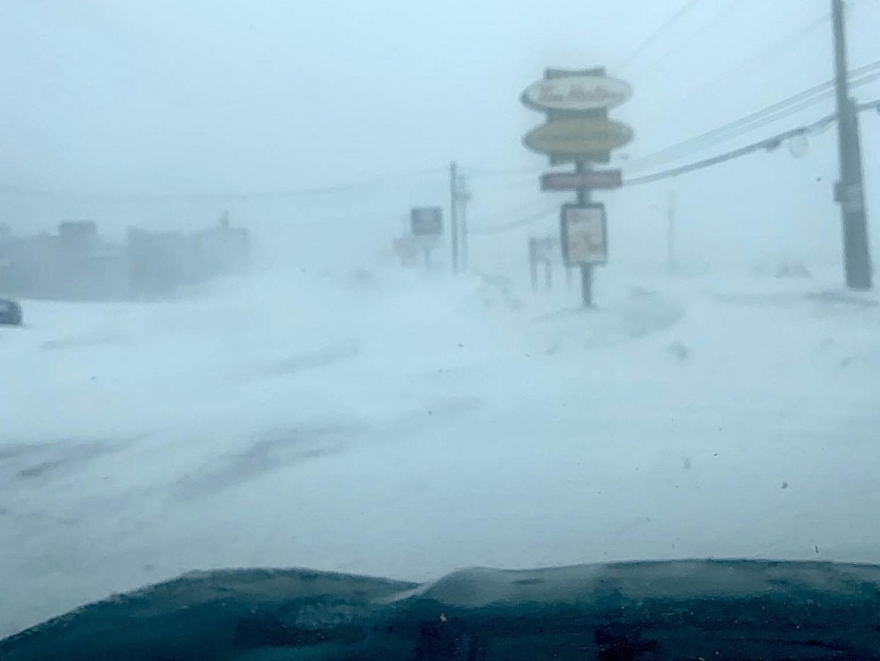
Thumbnail courtesy of Dianne Mercer/X.
Make sure to keep checking back to The Weather Network for forecast updates and impact information across Newfoundland.

