2 tropical storm systems take aim at Texas, Southeast
June 17 (UPI) -- Two tropical storm systems, forming in the southern Gulf of Mexico and in the Atlantic Ocean, could impact much of the southern United States this week to kick off what is forecast to be a "very active" 2024 Atlantic hurricane season.
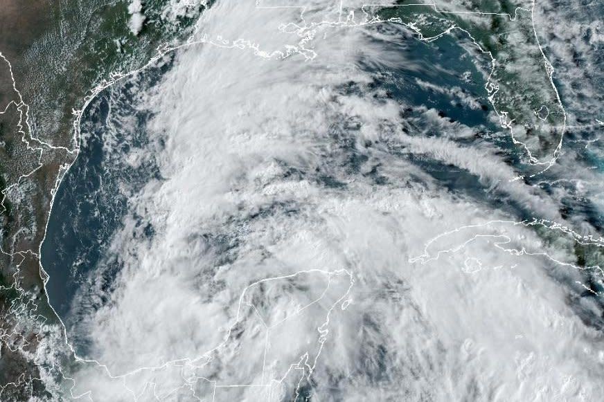
A tropical storm watch is in effect for South Texas to northeastern Mexico. Tropical Storm Alberto, the first named storm of the hurricane season, is expected to bring heavy flooding with up to 15 inches to Texas and Louisiana in the next 48 hours.
A "large disturbance is producing heavy rains and gusty winds in southern Mexico, Central America and surrounding waters," the National Hurricane Center's Tropical Analysis and Forecast Branch wrote Monday in a post on X.
"Several days of heavy rainfall are expected and these rains are likely to cause life-threatening flooding and flash flooding."
6/17 - Large disturbance is producing heavy #rains & gusty #winds in southern #Mexico, Central America & surrounding waters. Several days of heavy rainfall are expected & these rains are likely to cause life-threatening #flooding & #flashflooding. More at https://t.co/26J6Uoh0VW pic.twitter.com/Ihc1rktLeL— NHC_TAFB (@NHC_TAFB) June 17, 2024
On Monday afternoon, the National Hurricane Center designated the storm a Potential Tropical Cyclone One. The low pressure system was producing 40 mph winds in the Bay of Campeche. A tropical depression is forecast to form by midweek and is expected to hit the northern coast of Mexico by Thursday.
"All eyes are on Potential Tropical Cyclone One! Regardless of formation, heavy to excessive rainfall will be possible for portions of the Western Gulf Coast over the next several days," the National Weather Service warned Monday afternoon.
"There is now a high, 70%, probability of formation of a tropical depression/storm in the Bay of Campeche. Regardless of tropical development, periods of heavy rainfall are expected this week in southeast Texas, especially near and along the coast," the National Weather Service wrote in a post on X.
There is now a high (70%) probability of formation of a tropical depression/storm in the Bay of Campeche. Regardless of tropical development, periods of heavy rainfall are expected this week in SE TX especially near and along the coast. Stay weather aware. #TXwx #HOUwx #GLSwx pic.twitter.com/hoIcLoHRgD— NWS Houston (@NWSHouston) June 16, 2024
A second storm is forming this week in the Atlantic Ocean, east of the Bahamas, and is "forecast to approach the coast of the southeast United States on Thursday or Friday," according to the National Hurricane Center.
"This appears to be a quick-moving and compact low-pressure area that will be moving westward into northeastern Florida or perhaps as far north as southeastern Georgia on Thursday," according to AccuWeather senior meteorologist Dan Pydynowski.
The storm in the Atlantic has a 30% chance of becoming a tropical depression in the next seven days.
"While the exact details still remain very uncertain due to differences in guidance, the potential for heavy downpours for the middle to the end of the week will lead to the potential for localized flooding concerns to return to portions of South Florida," said NWS meteorologists.
This week's tropical storms are just the start of this year's Atlantic hurricane season, which officially began June 1 and is forecast to become one of the most active on record, according to AccuWeather.
"The 2024 Atlantic hurricane season is forecast to feature well above the historical average number of tropical storms, hurricanes, major hurricanes and direct U.S. impacts," said AccuWeather Lead Hurricane Forecaster Alex DaSilva.
"There is a 10-15% chance of 30 or more storms this year," he added. "All indications are pointing toward a very active Atlantic Hurricane season in 2024."

