9 Day Forecast: 70% chance of storms Wednesday, triple digits on 4th of July
El Paso, Texas (KTSM) — Good evening, Borderland.
The National Weather Service has issued an Flash Flood Advisory for Sunday for Central El Paso County. The warning is expected to expire at 4 p.m. Sunday.
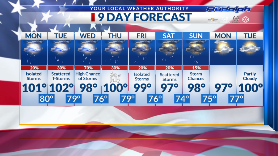
Storm chances are very much present starting Monday, and we can expect storms chances to peak on Wednesday.
Monday, we are forecasting a high of 101 degrees with a 20% chance of isolated storms in the afternoon. Our overnight low remains fairly warm, sitting at 80 degrees.
For Tuesday, 102 degrees is the predicted high, with a 30% chance of scattered storms throughout El Paso starting in the afternoon. Humidity will also be a factor this day.
Wednesday is forecasted to be an eventful day, weather-wise. We are predicting our high to reach 98 degrees, knocking us off our triple-digit streak. Additionally, we have a 70% chance of thunderstorms, beginning in the morning lingering into the evening. Our evening temperatures will cool off to 76 degrees.
The Fourth of July will be a humid day, with a 30% chance of isolated scattered storms. We can expect our high to warm up to 100 degrees with an overnight low of 79 degrees.
I hope everyone celebrates Independence Day responsibly! If you are looking around for events for July Fourth you can click on the article below.
Friday through Sunday, we are expecting to see a continued pattern of precipitation with our highs remaining in the double digits.
Copyright 2024 Nexstar Media, Inc. All rights reserved. This material may not be published, broadcast, rewritten, or redistributed.
For the latest news, weather, sports, and streaming video, head to KTSM 9 News.

