Beryl charts its course towards South Texas, eyeing what could become the first US landfall of the 2024 Atlantic season
Tropical Storm Beryl will strengthen as it tracks toward the south Texas coast late this weekend, bringing a risk of damaging winds, life-threatening storm surge and dangerous flooding to Texas beginning late Sunday. It’s expected to mark the first US landfall storm of the 2024 Atlantic season. Here’s the latest:
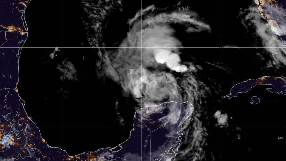
• Beryl expected to regain strength before landfall: Beryl, currently a tropical storm, has entered the Gulf of Mexico and was about 545 miles from Corpus Christi, Texas, Saturday morning. The storm has unloaded strong winds, torrential rainfall and dangerous storm surge over much of Mexico’s Yucatan Peninsula after hammering several Caribbean islands. Next, Beryl is expected to strengthen again Sunday ahead of its projected final landfall in South Texas.
• Hurricane and storm surge watches issued: Hurricane and storm surge watches were extended eastward along the Texas coast Friday night. The Texas coast is under hurricane watch from the mouth of the Rio Grande north to San Luis Pass. A storm surge watch is also in effect for the Texas coast from the Rio Grande north to High Island, including coastal Harris County. A hurricane watch is in effect for the northeastern coast of Mexico, from Barra el Mezquital to the mouth of the Rio Grande.
• Beryl expected to slam South Texas: Beryl is forecast to make landfall near Corpus Christi as a Category 1 hurricane midday Monday, according to the National Hurricane Center. Texas Lt. Gov. Dan Patrick said the state is likely to start seeing the impacts of Beryl starting Sunday into Monday. “We pray and we hope for nothing more of a rain event, but even a rain event may be very heavy,” Patrick said. “We prepare at the state for the worst-case scenario.”
• Dangerous storm surge along US Gulf Coast: Tropical storm conditions will begin to be felt along the western Gulf Coast on Sunday, with hurricane conditions expected later in the day. Storm surge up to 5 feet is forecast for southern parts of the Texas Coast. Heavy rainfall of 5 to 10 inches, with localized amounts of 15 inches, is forecast across the Texas Gulf Coast and eastern Texas late Sunday through the middle of next week, the National Hurricane Center said. It’s expected to produce flash and urban flooding. Rip currents will cause life-threatening beach conditions through the weekend across much of the Gulf Coast.
• At least nine dead due to Beryl: Beryl became the earliest Category 5 hurricane in the Atlantic on record earlier this week. The storm killed at least nine people in the Caribbean, including two in Jamaica, three in Venezuela, three in Grenada and one person in Saint Vincent and the Grenadines.
• Beryl worsened by climate change: The abnormally warm ocean waters that facilitated Beryl’s intensification show that this hurricane season will be far from normal. Beryl’s blow to Jamaica was worsened by climate change, a new rapid attribution analysis from ClimaMeter found. Modern storms like Beryl tracking close to Jamaica are capable of unloading 30% more rain and 10% stronger winds compared to the similar storms from 1979 to 2001 because of human-caused climate change, the study found.
• How to help those impacted: Jamaican residents are assessing the damage after Beryl pounded the Caribbean island with destructive winds and storm surge. The storm killed two people in the country and left hundreds of thousands of homes without power. Beryl was the strongest storm to impact the country in more than 15 years. Beryl also caused major damage across the region, including in St. Vincent and the Grenadines, Barbados and Grenada. Several charities are actively distributing aid throughout the region. Contribute to relief efforts here.
unknown content item
-
Texas officials ask residents to evacuate along coast
Texas officials are urging residents to prepare before Beryl’s expected hit to coastal areas later this weekend.
“Everyone along the coast should be paying attention to this storm,” Lt. Gov. Patrick said during a briefing on Friday.
Already, several counties along the Texas Coast have asked residents to evacuate due to the potentially dangerous conditions Beryl could bring. Texas Gov. Greg Abbott has also issued severe weather disaster declarations for 40 counties, as the state contends with “heavy rainfall, flooding conditions, and strong tropical wind.”
Matagorda County issued a voluntary evacuation order ahead of Beryl’s arrival, the county’s Emergency Operation Center said on social media. The order calls for people to voluntarily evacuate coastal areas in the county including Sargent, Matagorda and Palacios.
Aransas County’s emergency management office called for voluntary evacuations too.
“Please take all precautions to prepare your family for this potentially hazardous weather event. Residents in low-lying areas, those with special needs, or those housed in RVs should immediately begin voluntary evacuations,” the county posted on Facebook.
In Kleberg County, Judge Rudy Madrid issued a “Voluntary Evacuation for Baffin Bay, Loyola Beach and all low lying areas,” according to a social media post from the City of Kingsville.
Nueces County Judge Connie Scott asked citizens on the coast in low-lying areas or who need assistance to evacuate due to the possibility of the storm making landfall in the area as a hurricane, the county posted on social media.
The National Weather Service in Corpus Christi is warning residents that “now would be the time to prepare” for Beryl as its track forecast is trending farther north along the Texas coast.
“Residents should really be aware that the earliest … arrival of the tropical storm force winds is predicted for Sunday afternoon,” Corpus Christi Mayor Paulette Guajardo said on Friday.
Guajardo asked those visiting the city for the Fourth of July weekend to “please consider returning at an earlier time if it’s what you feel you need to do.”
In Houston, the weather service is likewise asking people to stay vigilant.
“At this time, the main impacts for SE TX will remain increased rainfall (Mon/Tues) and the potential for tropical storm force winds (34kts) as early as Sun morning. Stay tuned and stay informed,” the weather service posted on X.
Editor’s Note: Affected by the storm? Use CNN’s lite site for low bandwidth.
CNN’s Dave Alsup, Raja Razek, Monica Garrett, Elise Hammond, Mary Gilbert and Eric Zerkel contributed to this report.
For more CNN news and newsletters create an account at CNN.com

