Beryl dumps final load of rain. See expected impact as disturbance off US coast moves inland
A low-pressure system off the southeast coast of the United States should be fully inland this afternoon, according to the latest advisory from the National Hurricane Center.
Upper-level winds prevented the system from developing into a tropical cyclone, but heavy rain and possible flash floods may occur across portions of the Carolinas and Mid-Atlantic through tonight.
Rain associated with the remnants of Beryl brought locally heavy rain to northern New York to northern New England into Thursday night, said AccuWeather. Some areas saw up to 8 inches of rain.
Now new tropical moisture along the Atlantic coast will bring additional rain, especially along much of the Interstate 95 corridor today and into the weekend. Local amounts of 6 to 8 inches can occur in 24 hours or less, forecasters said.
Elsewhere in the tropics, the National Hurricane Center is monitoring five tropical waves, including two in the Caribbean.
Tropics should remain quiet until end of July but 'don't let your guard down'
AccuWeather forecasters are predicting the tropics should remain quiet until the end of the month due to Saharan dust and strong wind shear in the Atlantic basin. Both tend to decrease the risk for storms to develop or strengthen.
"We're in the doldrums of the season," said Alex DaSilva, AccuWeather lead hurricane expert. "There's always the possibility, but we don't see (another Beryl) happening."
By the end of July or beginning of August, things could try to ramp up.
"We're still expecting a very, very busy season," DaSilva said. "Don't let your guard down. Don't be fooled by the quiet period. We're at the very beginning of hurricane season. It will ramp up and it could ramp up very quickly."
The next storm of the season will be Debby.
Here's the latest update from the NHC as of 2 p.m. July 12:
What is NOAA tracking in Atlantic basin?

Low pressure system off coast of North and South Carolina: A broad area of low pressure centered near the South and North Carolina coastline continues to produce disorganized showers and thunderstorms.
Strong upper-level winds should limit any development of this system before it moves fully inland this afternoon.
However, the disturbance could contribute to areas of heavy rainfall and possible flash flooding across coastal portions of the Carolinas and Mid-Atlantic through tonight.
Formation chance through 48 hours: low, near 0 percent.
Formation chance through 7 days: low, near 0 percent.
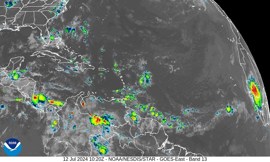
Elsewhere in the tropics, the National Hurricane Center is monitoring:
Tropical wave 1: A tropical wave in the eastern Atlantic is moving west at 11 to 17 mph.
Tropical wave 2: Another tropical wave in the eastern Atlantic is moving west at 11-17 mph.
Tropical wave 3: A tropical wave in the central Atlantic is moving west at 17 mph.
Tropical wave 4: A tropical wave in the eastern Caribbean is moving west at 23 mph.
Tropical wave 5: A tropical wave in the western Caribbean is moving west at 11 mph.
Who is likely to be impacted?
Area of low pressure off Carolinas: Heavy rainfall and possible flash flooding across coastal portions of the Carolinas and Mid-Atlantic through tonight. Some areas could see 6-8 inches over 24 hours.
Forecasters urge all residents to continue monitoring the tropics and to always be prepared. That advice is particularly important for what is expected to be a very active hurricane season.
Weather watches and warnings issued in Florida
When is the Atlantic hurricane season?
The Atlantic hurricane season runs from June 1 through Nov. 30.
When is the peak of hurricane season?
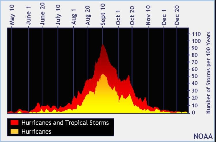
The peak of the season is Sept. 10, with the most activity happening between mid-August and mid-October, according to the Hurricane Center.
National Hurricane Center map: What are forecasters watching now?
Systems currently being monitored by the National Hurricane Center include:

Interactive map: Hurricanes, tropical storms that have passed near your city
Excessive rainfall forecast
What's next?
We will continue to update our tropical weather coverage daily. Download your local site's app to ensure you're always connected to the news. And look for our special subscription offers here.
This article originally appeared on Treasure Coast Newspapers: NHC tracking tropical disturbance off coast, 5 tropical waves. Impact

