Beryl to hit Texas on Monday, with high winds and possible tornadoes by Sunday afternoon
With less than a day until landfall, Beryl remains a tropical storm but is expected to intensify into a Category 1 hurricane before reaching the Texas coast on Monday morning. But Beryl's impact will be felt far beforehand.
The latest advisories from the National Hurricane Center warn of tropical-storm-force winds and possible tornadoes along the Texas coast as early as Sunday afternoon.
The region will also see heavy rainfall, storm surge and swells with life-threatening riptides.
More: Prepare for Hurricane Beryl, says Lt. Gov. Patrick: 'A determined storm that is still strong'
On Monday, Beryl made landfall in Grenada's Carriacou Island as a Category 4 hurricane, ravaging the southern Caribbean Islands, flattening hundreds of buildings and killing at least six people. Later Monday night, it became the earliest Category 5 hurricane on record. Driven by record-high ocean temperatures, Beryl's rapid strengthening stunned experts.
Beryl also was the earliest Category 4 hurricane on record — before dropping to Category 3 on Monday — and is the first June major hurricane east of the Lesser Antilles on record.
If the storm does make landfall as a hurricane, Beryl would be the 10th hurricane to do so in July, Phil Klotzbach, a research scientist at Colorado State University, wrote on X.
9 #hurricanes have made landfall in Texas in July on record (since 1851). These hurricanes are: Storm 1 (1866), Storm 1 (1891), Velasco (1909), Storm 3 (1934), Storm 1 (1943), Debra (1959), Claudette (2003), Dolly (2008), Hanna (2020). #Berylhttps://t.co/pts7vQYiCO pic.twitter.com/n4H4OooJbN
— Philip Klotzbach (@philklotzbach) July 6, 2024
Where is Hurricane Beryl going to hit? Track projected path
Location: 195 miles southeast of Corpus Christi, Texas; 195 miles south-southeast of Matagorda, Texas
Maximum sustained winds: 65 mph
Movement: northwest at 10 mph
When is Hurricane Beryl expected to make landfall?
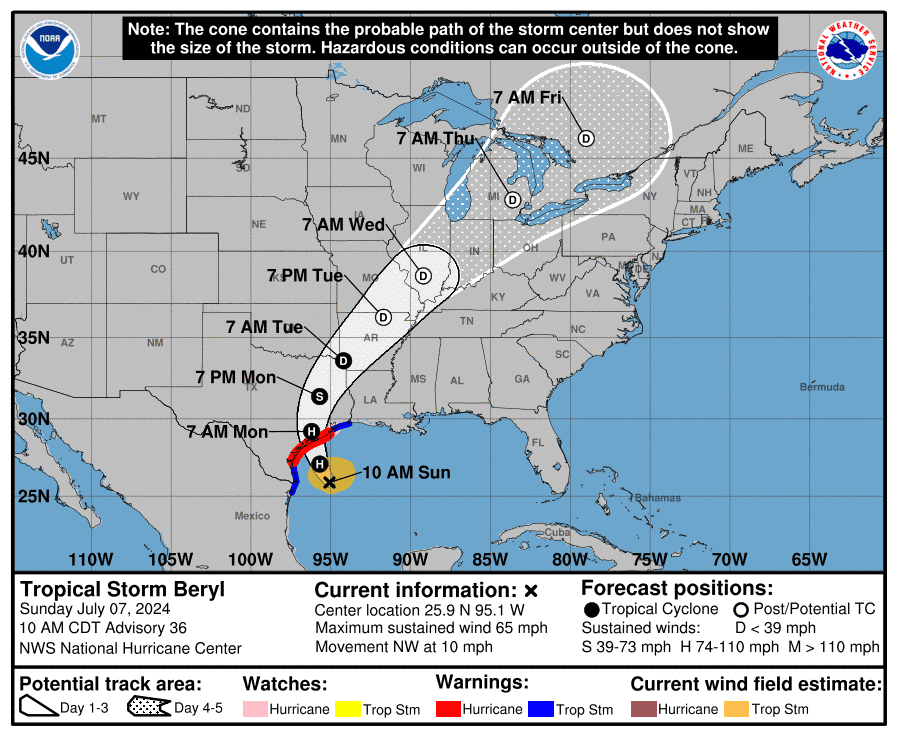
As of 10 a.m., the center of Tropical Storm Beryl was approximately 195 miles southeast of Corpus Christi and 195 miles south-southeast of Matagorda. The storm was forecast to turn toward the northwest later Saturday and then north-northwestward by Sunday night.
The historic storm currently has maximum sustained winds near 65 mph with tropical-storm-force winds extending outward up to 125 miles from the center.
On the forecast track, the center of Beryl is expected to approach the Texas coast by late Sunday into Monday morning. It is likely to intensify into a Category 1 hurricane before landfall along the mid-Texas coast on Monday morning. The National Weather Service office in Corpus Christi advises residents to prepare for a Category 2.
How will Hurricane Beryl impact Texas?
The NWS office warns residents to plan for other impacts of the storm, including "scattered tornadoes (which) can hinder emergency plans during tropical events." Other possible impacts of the storm include:
Wind: Hurricane conditions are expected in the hurricane warning area by early Monday. Winds are first expected to reach tropical storm strength by late Sunday, making outdoor preparations difficult or dangerous. Hurricane conditions are possible in the hurricane watch areas in Texas by early Monday, with tropical storm conditions beginning by late Sunday or Sunday night.
Storm surge: The deepest water will occur along the immediate coast near and to the right of the center, where the surge will be accompanied by large and destructive waves. Surge-related flooding depends on the relative timing of the surge and the tidal cycle, and can vary greatly over short distances.
Rainfall: Heavy rainfall of 5 to 10 inches with localized amounts of 15 inches is expected across portions of the Texas Gulf Coast and eastern Texas beginning late Sunday through the middle of next week. This rainfall is likely to produce flash floods and urban flooding, some of which may be locally considerable. Minor to isolated moderate river flooding is also possible.
Swells: Large swells generated by Beryl are currently impacting portions of the coast of the Yucatan Peninsula. The swells are expected to reach eastern Mexico and much of the Gulf Coast of the U.S. shortly. These swells are expected to cause life-threatening surf and rip current conditions.
More: Austin lands within Hurricane Beryl's possible path, though forecast not yet certain
Acting Gov. Dan Patrick issues disaster declaration for nearly half of Texas' counties
Lt. Gov. Dan Patrick — currently Acting Governor as Gov. Greg Abbott leads a weeklong trip in Asia — has issued a disaster declaration for 121 Texas counties.
“Based on the current forecast, heavy rain and some localized flooding could occur all the way from the coast through areas near College Station, Tyler, and Texarkana as the storm moves through Texas on its current track," Patrick said in a release. "The track may change over the next 40 hours. Texans need to take heed, watch their local officials, and prepare today and tomorrow before the storm makes landfall early Monday morning."
The following 121 Texas counties are part of the disaster declaration: Anderson, Angelina, Aransas, Atascosa, Austin, Bastrop, Bee, Bell, Bexar, Bowie, Brazoria, Brazos, Brooks, Burleson, Caldwell, Calhoun, Cameron, Camp, Cass, Chambers, Cherokee, Collin, Colorado, Comal, Dallas, Delta, DeWitt, Dimmit, Duval, Ellis, Falls, Fannin, Fayette, Fort Bend, Franklin, Freestone, Frio, Galveston, Goliad, Gonzales, Grayson, Gregg, Grimes, Guadalupe, Hardin, Harris, Harrison, Hays, Henderson, Hidalgo, Hill, Hopkins, Houston, Hunt, Jackson, Jasper, Jefferson, Jim Hogg, Jim Wells, Karnes, Kaufman, Kenedy, Kinney, Kleberg, Lamar, Lavaca, LaSalle, Lee, Leon, Liberty, Limestone, Live Oak, Madison, Marion, Matagorda, Maverick, McLennan, McMullen, Medina, Milam, Montgomery, Morris, Nacogdoches, Navarro, Newton, Nueces, Orange, Panola, Polk, Rains, Red River, Refugio, Robertson, Rockwall, Rusk, Sabine, San Augustine, San Jacinto, San Patricio, Shelby, Smith, Starr, Titus, Travis, Trinity, Tyler, Upshur, Uvalde, Van Zandt, Victoria, Walker, Waller, Washington, Webb, Wharton, Willacy, Williamson, Wilson, Wood, Zapata, and Zavala. Additional counties may be added as conditions warrant.
"Do not ignore this storm," Patrick warned.
Spaghetti models: Where will Hurricane Beryl go next?
Special note about spaghetti models: Illustrations include an array of forecast tools and models, and not all are created equal. The Hurricane Center uses only the top four or five highest-performing models to help make its forecasts.
Watches and warnings issued for Hurricane Beryl in Texas
Hurricane warning
A hurricane warning is in effect for the following:
The Texas coast from Baffin Bay northward to San Luis Pass
A Hurricane warning means that hurricane conditions are expected somewhere within the warning area. Preparations to protect life and property should be rushed to completion.
Hurricane watch
A hurricane watch is in effect for the following:
The Texas coast north of San Luis Pass to Galveston Island
A hurricane watch means that hurricane conditions are possible within the watch area. A watch is typically issued 48 hours before the anticipated first occurrence of tropical-storm-force winds, conditions that make outside preparations difficult or dangerous.
Tropical storm warning
A tropical storm warning is in effect for the following:
The Texas coast south of Baffin Bay to the mouth of the Rio Grande River
The Texas coast north of San Luis Pass to High Island
The northeastern coast of mainland Mexico from Barra el Mezquital to the mouth of the Rio Grande River
A Tropical Storm Warning means that tropical storm conditions are expected somewhere within the warning area within 36 hours.
Storm surge warning
A storm surge warning is in effect for the following:
North Entrance of the Padre Island National Seashore to Sabine Pass, including Corpus Christi Bay, Matagorda Bay, and Galveston Bay
A Storm surge warning means there is a danger of life-threatening inundation, from rising water moving inland from the coastline, during the next 36 hours in the indicated locations
Storm surge watch
A storm surge watch is in effect for the following:
North of Baffin Bay, Texas to North Entrance of the Padre Island National Seashore
A storm surge watch means there is a possibility of life-threatening inundation, from rising water moving inland from the coastline, in the indicated locations during the next 48 hours.
This article originally appeared on Lubbock Avalanche-Journal: Beryl to bring heavy rain, tornadoes before Texas landfall Monday

