Beryl to make landfall in Texas as a hurricane on Monday, storm surge, flood warnings issued
Beryl is set for a threepeat: The storm already made landfall twice in a week and it's set for a third landfall, according to the National Hurricane Center in Miami.
The hurricane center continued issuing advisories on Tropical Storm Beryl. Tropical storm warnings are now in place in southern Texas ahead of Beryl, which is expected to be a hurricane near landfall.
At 8 a.m. EDT Sunday, the center of Tropical Storm Beryl was 225 miles south-southeast of Matagorda, Texas, and 220 miles southeast of Corpus Christi, Texas, with maximum sustained winds at 60 mph. Beryl was moving northwest at 12 mph. Interests elsewhere along the northwestern Gulf of Mexico coast should closely monitor the progress of Beryl.
On the forecast track, the center of Beryl is expected to make landfall on the Texas coast Monday morning.
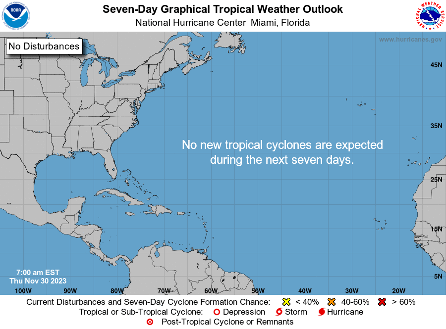
Other than Beryl, as of 8 a.m. Sunday, July 7, tropical cyclone formation was not expected during the next 7 days.
How fast did Beryl form? What do we know about landfall?
From Invest 95L to Beryl: As we track Beryl's path, here's a look back at the tropical storm that strengthened into a hurricane and made landfall twice in one week. Experts predict Beryl to make landfall a third time as a hurricane.
Hurricane season runs June 1 to Nov. 30, with the busiest part of the season between August and October.
On Friday, June 28, 2024, the National Hurricane Center in Miami issued advisories on "Invest 95L." At 11 p.m. June 28, the tropical cyclone became Tropical Storm Beryl.
On Saturday, June 29, the National Hurricane Center reported Beryl strengthened into hurricane status by 5 p.m.
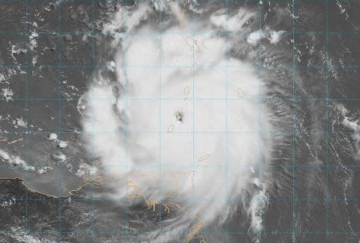
On Monday, July 1, Beryl was a powerful Category 4 hurricane that hit Carriacou Island, Grenada, with 150-mph winds. The photo below by the National Oceanic and Atmospheric Administration shows Beryl at landfall days ahead of the July Fourth holiday.
On Tuesday, July 2, Hurricane Beryl strengthened into a Category 5 storm with 165 mph winds.
On Friday, July 5, Beryl weakened into a tropical storm, but made landfall near Tulum, Mexico, on the Yucatan Peninsula as a Category 2 storm, according to the National Hurricane Center. That was Beryl's second landfall in a week. By then, the storm was moving ashore as a Category 2 with 110-mph winds.
On Saturday, July 6, Tropical Storm Beryl was projected to become a hurricane when it makes landfall (potentially the storm's third) in northeastern Mexico or southern Texas late Sunday into Monday, according to the National Hurricane Center.
While Florida won't be directly affected by Beryl, the hurricane center warned of life-threatening surf and dangerous rip currents associated with the storm along the Gulf Coast, from Florida to Mexico.
Here's the latest update from the NHC as of 8 a.m. Sunday, July 7:
Spaghetti models: Where will Hurricane Beryl go next?
Special note about spaghetti models: Illustrations include an array of forecast tools and models, and not all are created equal. The Hurricane Center uses only the top four or five highest performing models to help make its forecasts.
How could Hurricane Beryl affect Florida?
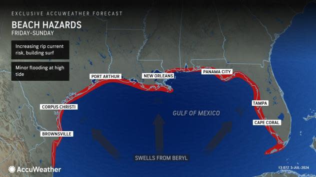
Large swells generated by Beryl are expected to reach much of the Gulf Coast of the U.S. — including all of Florida's West Coast and Panhandle. The swells are expected to cause life-threatening surf and rip current conditions.
Watches, warnings issued across Florida
Hurricane Beryl: What you need to know
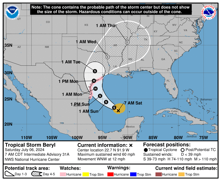
Location: 225 miles south-southeast of Matagorda, Texas, and 220 miles southeast of Corpus Christi, Texas
Maximum sustained winds: 60 mph
Movement: northwest at 12 mph
Watches and warnings issued for Tropical Storm Beryl
Hurricane warning: A hurricane warning is in effect for the following:
The Texas coast from Baffin Bay northward to San Luis Pass
A hurricane warning means that hurricane conditions are expected somewhere within the warning area. A warning is typically issued 36 hours before the anticipated first occurrence of tropical-storm-force winds, conditions that make outside preparations difficult or dangerous. Preparations to protect life and property should be rushed to completion.
Hurricane watch: A hurricane watch is in effect for the following:
The Texas coast from south of Baffin Bay to the mouth of the Rio Grande
The Texas coast north of San Luis Pass to Galveston Island
A hurricane watch means that hurricane conditions are possible within the watch area. A watch is typically issued 48 hours before the anticipated first occurrence of tropical-storm-force winds, conditions that make outside preparations difficult or dangerous.
Tropical storm warning: A tropical storm warning is in effect for the following:
The Texas coast south of Baffin Bay to the mouth of the Rio Grande River
The Texas coast north of Sargent to High Island
The northeastern coast of mainland Mexico from Barra el Mezquital to the mouth of the Rio Grande River
A tropical storm warning means that tropical storm conditions are expected somewhere within the warning area within 36 hours.
Storm surge warning: A storm surge warning is in effect for the following:
North Entrance of the Padre Island National Seashore to High Island, including Corpus Christi Bay, Matagorda Bay, and Galveston Bay
A storm surge warning means there is a danger of life-threatening inundation, from rising water moving inland from the coastline, in the indicated locations. This is a life-threatening situation. Persons located within these areas should take all necessary actions to protect life and property from rising water and the potential for other dangerous conditions. Follow evacuation and other instructions from local officials.
Storm surge watch: A storm surge watch is in effect for the following:
The Texas coast from the mouth of the Rio Grande River northward to north entrance of Padre Island National Seashore
High Island to Sabine Pass
A storm surge watch means there is a possibility of life-threatening inundation, from rising water moving inland from the coastline, in the indicated locations during the next 48 hours.
A Tropical Storm Watch is in effect for:
The Texas coast east of High Island to Sabine Pass
A Tropical Storm Watch means that tropical storm conditions are possible within the watch area.
Hurricane Beryl: Here's latest information on strength, forecast path
At 8 a.m. Sunday, the center of Tropical Storm Beryl was located by an Air Force reconnaissance aircraft near latitude 25.5 North, longitude 94.9 West. Beryl was moving toward the northwest near 12 mph, and this motion should continue through today. A turn toward the north-northwest is expected tonight, witha turn toward the north on Monday. On the forecast track, the center of Beryl is expected to make landfall on the Texas coast Monday morning.
Maximum sustained winds remain near 60 mph with higher gusts. Strengthening is expected, and Beryl is forecast to become a hurricane again later today or tonight before it reaches the Texas coast.
Tropical-storm-force winds extend outward up to 125 miles from the center.
How strong is Tropical Storm Beryl and where is it going?
Here's how strong Beryl is expected to get:
Currently: 60 mph
12 hours: 65 mph
24 hours: 75 mph
36 hours: 85 mph
48 hours: 70 mph, inland
60 hours: 40 mph, inland
72 hours: 30 mph, inland
96 hours: 25 mph, post-tropical, inland
120 hours: 25 mph, post-tropical/inland
Key messages from the National Hurricane Center: What you need to know about Hurricane Beryl
There is a danger of life-threatening storm surge inundation late Sunday night and Monday along the coast of Texas from the north entrance of Padre Island National Seashore to San Luis Pass. Residents in that area should follow any advice given by local officials and fellow evacuation orders.
Beryl is forecast to bring damaging hurricane-force winds to portions of the lower and middle Texas coast late Sunday into Monday. A hurricane warning is now in place from Baffin Bay to Sargent. Preparations should be rushed to completion before tropical storm conditions begin late Sunday.
Flash and urban flooding, some of which may be locally considerable, is likely across portions of the Texas Gulf Coast and eastern Texas beginning late Sunday through the middle of next week. River flooding is also possible.
Rip currents will cause life-threatening beach conditions through the weekend across much of the Gulf Coast. Beachgoers should heed warning flags and the advice of lifeguards and local officials before venturing into the water.
What impact could Hurricane Beryl have and what areas could be affected?
What is storm surge? Graphics explain the deadly weather event
Wind: Hurricane conditions are expected in the hurricane warning area by early Monday. Winds are first expected to reach tropical storm strength by late today, making outdoor preparations difficult or dangerous.
Hurricane conditions are possible in the hurricane watch areas by early Monday, with tropical storm conditions beginning by tonight.
Tropical storm conditions are expected in the tropical storm warning areas in Texas and northeastern Mexico by tonight.
Tropical storm conditions are possible within the watch area in Texas by tonight.
Storm surge: The combination of storm surge and tide will cause normally dry areas near the coast to be flooded by rising waters moving inland from the shoreline. The water could reach the following heights above ground somewhere in the indicated areas if the peak surge occurs at the time of high tide.
Mesquite Bay, Texas, to San Luis Pass, Texas: 4 to 6 feet
Matagorda Bay: 4 to 6 feet
Sargent, Texas, to San Luis Pass, Texas: 3 to 5 feet
North entrance of Padre Island National Seashore, Texas to Mesquite Bay: 3 to 5 feet
Corpus Christi Bay: 3 to 5 feet
Mouth of the Rio Grande, Texas, to north entrance of Padre Island National Seashore: 2 to 4 feet
High Island, Texas, to Sabine Pass, Texas: 2 to 4 feet
Galveston Bay: 3 to 5 feet
Sabine Pass, Texas, to Cameron, Louisiana: 1 to 3 feet
The deepest water will occur along the immediate coast near and to the right of the center, where the surge will be accompanied by large and destructive waves. Surge-related flooding depends on the relative timing of the surge and the tidal cycle, and can vary greatly over short distances.
Rainfall: Heavy rainfall of 5 to 10 inches with localized amounts of 15 inches is expected across portions of the middle and upper Texas Gulf Coast and eastern Texas beginning today through Monday night. This rainfall will produce areas of flash and urban flooding, some of which may be locally considerable. Minor to isolated moderate river flooding is also expected.
Tornadoes: A tornado threat will likely develop this evening into tonight for portions of the middle and upper Texas coast.
Surf: Swells generated by Beryl are expected to affect eastern Mexico and much of the Gulf Coast of the U.S. during the next few days. These swells are expected to cause life-threatening surf and rip current conditions.
When is the Atlantic hurricane season?
The Atlantic hurricane season runs from June 1 through Nov. 30.
When is the peak of hurricane season?
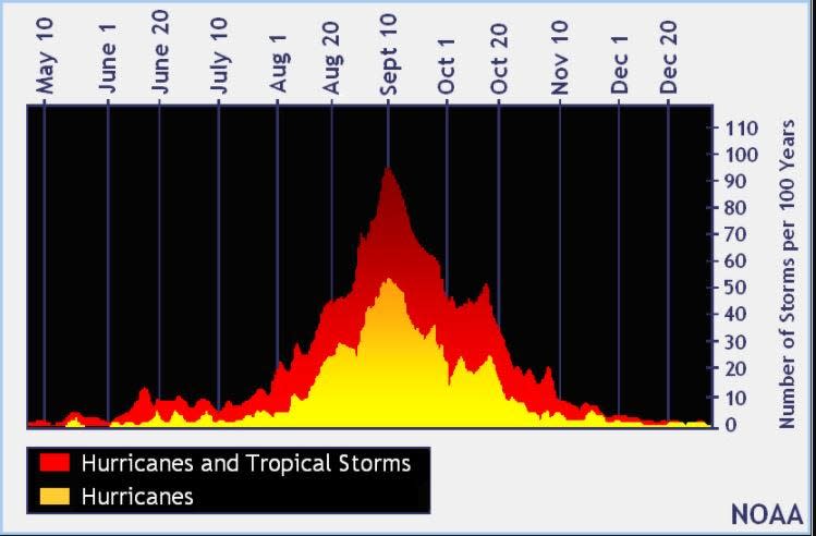
The peak of the season is Sept. 10, with the most activity happening between mid-August and mid-October, according to the Hurricane Center.
National Hurricane Center map: What are forecasters watching now?
Systems currently being monitored by the National Hurricane Center include:
Interactive map: Hurricanes, tropical storms that have passed near your city
Excessive rainfall forecast
What's next?
We will continue to update our tropical weather coverage daily. Download your local site's app to ensure you're always connected to the news. And look for our special subscription offers here.
This article originally appeared on Florida Today: Where is Hurricane Beryl? Track forecast, path before Texas landfall

