Beryl live updates: Storm expected to slam into Texas coast as hurricane
Tropical Storm Beryl is targeting the Gulf Coast of Texas after dealing a destructive blow to several islands in the Caribbean and the resort coast of Mexico's Yucatan Peninsula.
Beryl is projected to re-strengthen into a hurricane before it makes landfall just north of the U.S.-Mexico border late Sunday into Monday morning.
Beryl, the earliest Category 5 Atlantic hurricane in history, killed at least seven people in the Windward Islands -- including Grenada and Carriacou -- before skirting south of Jamaica, shutting down communications, stranding tourists and delivering storm surge and flooding rain to the island.
Latest Developments
Jul 7, 1:40 PM
Houston school campuses close as Beryl approaches
The Houston Independent School District announced Sunday that all its campuses will be closed as tropical storm Beryl bears down on the Texas coast and is expected to be a Category 1 hurricane when it makes landfall.
The school district sent out a message Sunday to students, staff and parents that it is canceling summer classes and activities, and closing all campuses and buildings on Monday and Tuesday.
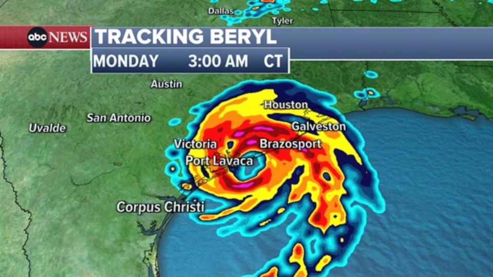
Beryl was a tropical storm on Sunday in the Gulf of Mexico, but is expected to strengthen overnight and make landfall on the Texas Gulf Coast as a Category 1 hurricane early Monday morning, according to the National Hurricane Center.
-ABC News' Gina Sunseri
Jul 7, 12:37 PM
Beryl could be a Category 1 hurricane when it slams Texas: NHC
Beryl remains a tropical storm but was gaining strength over open warm waters of the Gulf of Mexico and is forecast to be a Category 1 hurricane by Sunday night and is expected to make landfall on the Texas coast early Monday, according to the National Hurricane Center.
In an update on Beryl's path issued at 10 a.m. CT, the hurricane center said winds generated by Beryl had slightly increased to 65 mph.

"Beryl [is] becoming better organized and forecast to become a hurricane before landfall," the hurricane center said in its latest update.
The storm is expected to make landfall on the middle Texas Coast near Matagorda Bay on Monday.
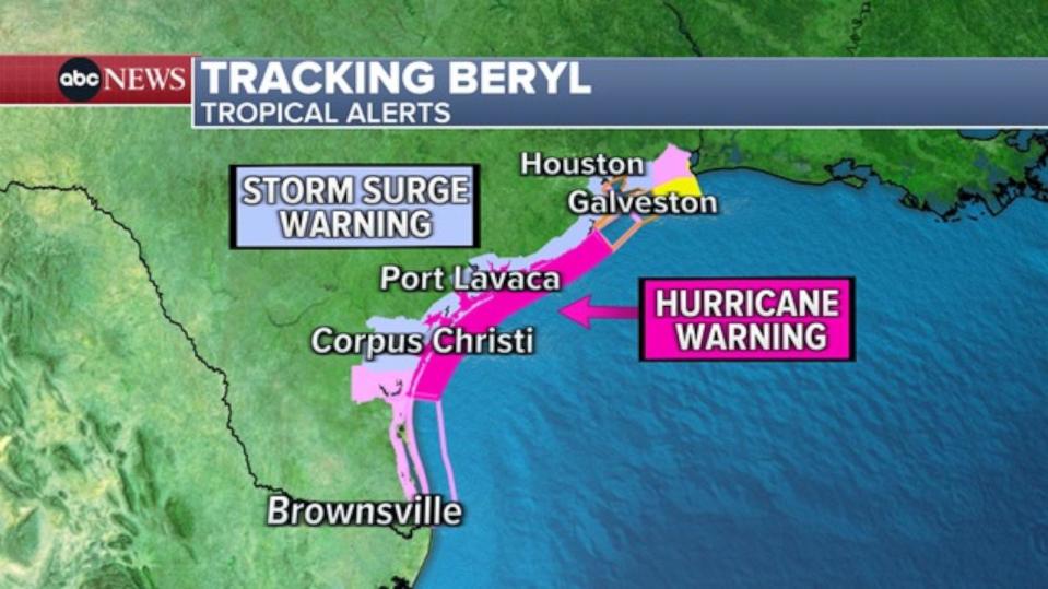
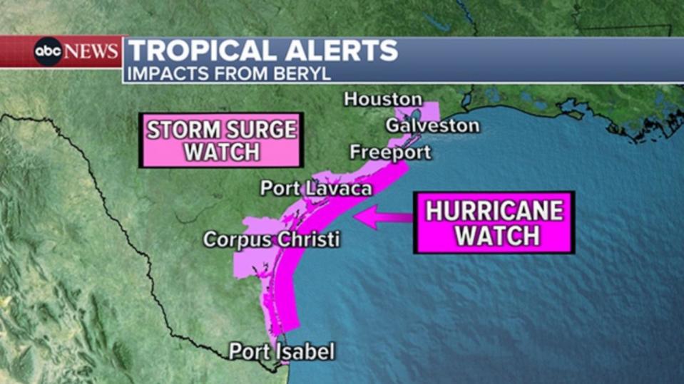
A Hurricane Warning has been issued for the Gulf Coast from Baffin Bay north to San Luis Pass. A Storm Surge Warning was also issued for the coast of Texas from High Island to Sabine Pass.
"Beryl is forecast to become a hurricane again later today. Continued strengthening is expected overnight before Beryl reaches the Texas coast," according to the hurricane center's statement.
The hurricane center warned that a few tornadoes could also occur along the middle and upper Texas Coast through Sunday night and across eastern Texas and western
Louisiana on Monday.
In addition to storm surges of up to 6 feet, Beryl is expected to dump heavy rain on the Texas coastal cities.
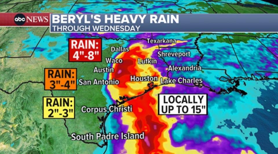
"Heavy rainfall of 5 to 10 inches with localized amounts of 15 inches is expected across portions of the middle and upper Texas Gulf Coast and eastern Texas beginning today through Monday night," the hurricane center said.
The White House said Sunday that President Joe Biden is monitoring Beryl as FEMA prepositions response teams.
"The President and his team continue to monitor Tropical Storm Beryl as it makes its way towards South Texas," a White House official said. "We are in close contact with our state and local counterparts and FEMA has prepositioned response personnel, search and rescue teams, bottled water, meals, tarps and electric generators in case they are needed. On Sunday, FEMA activated its National Response Coordination Center (NRCC) to further support local response efforts."
-ABC News' Daniel Amarante
Jul 7, 6:20 AM
Beryl to make landfall as hurricane Monday morning in Texas
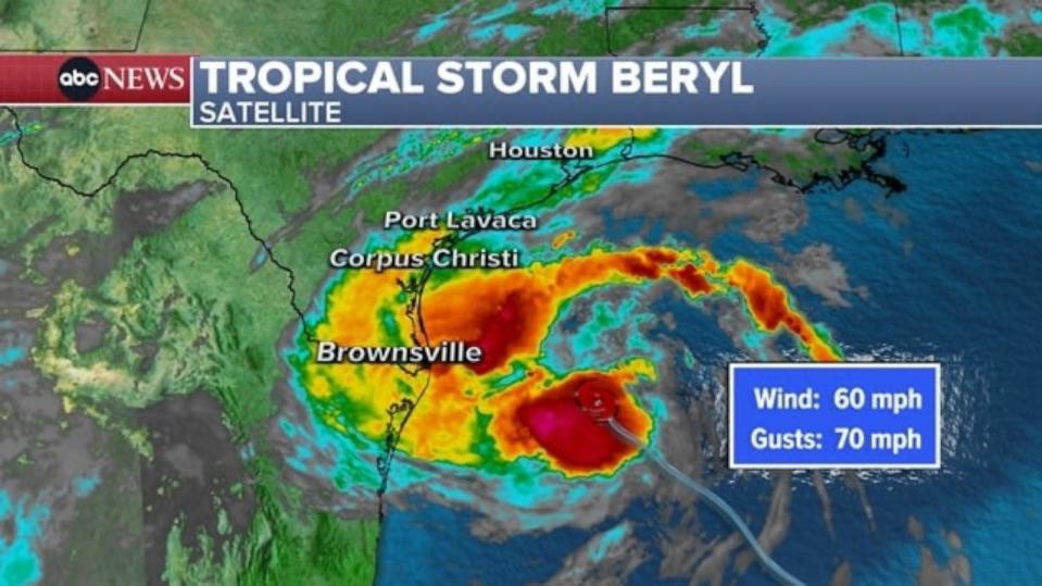
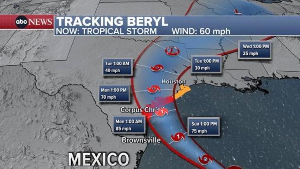
Beryl remained early Sunday a tropical storm with winds of 60 mph.
The storm has been slow to strengthen over the past several hours, which is potentially good news for the residents of the Texas coast.
Even though strengthening is expected, each hour that this storm delays that intensification will help contribute to a weaker storm upon landfall.
A hurricane warning is in effect from Baffin Bay to San Luis Pass.
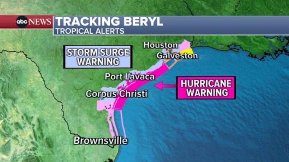
A storm surge warning is in effect for Corpus Christi Bay, Matagorda Bay, and Galveston Bay. During the peak of the storm on Monday morning, surge may reach 4 to 6 feet above normal tide in Mesquite Bay and Matagorda Bay.
There are also numerous other hurricane watches, tropical storm watches and warnings, and storm surge watches across the Texas coast.
Beryl is still forecast to make landfall near Matagorda Bay as a Category 1 Hurricane on Monday morning.
-ABC News’ Daniel Amarante
Jul 6, 10:25 PM
Galveston issues voluntary evacuation notice
An island city on the Gulf Coast of Texas issued a voluntary evacuation of the island's west end, Galveston officials said in a press release on Saturday.
While officials feel the chances of tides above five feet are currently very low, tides above that level could prevent travel on major roads and make it difficult for the city to respond to emergencies, the press release said.
Brian Maxwell, Galveston city manager, noted that predictions for the track of Beryl have not changed.
The size of Beryl has expanded slightly, according to the National Weather Service, and as a result, the island’s west end is currently under a storm surge warning.
Mayor Craig Brown "signed the order out of an abundance of caution," said Maxwell.
If residents choose to stay in a low-lying area, they may not be able to safely leave for several hours, and emergency services may not be available while tides remain elevated, emergency management officials said.
Jul 6, 5:09 PM
Beryl now less than 400 miles from Corpus Christi
Beryl, now less than 400 miles from Corpus Christi, remains a tropical storm with winds of 60 mph, moving at 13 mph.
Beryl is moving over water that is slightly warmer than normal, by 1 to 2 degrees.
As Beryl approaches the Texas coast it will move over much warmer waters, 4 and 5 degrees above normal. The warmer water is expected to help boost Beryl back into a hurricane before making landfall northeast of Corpus Christi on Monday morning.
Hurricane Warnings have been issued for parts of Texas, from Baffin Bay northward to Sargent. Tropical Storm Warnings are now issued north of Sargent to High Island.
Landfall may occur with the center of circulation most likely northeast of Corpus Christi -- the greatest impacts remaining north of that city as well. There is still time for this track to change over the next 24 hours.
The last hurricane to make landfall in Texas was Nicholas in September 2021, which was a Category 1 and made landfall on the northern side of East Matagorda Bay.
The last hurricane to make landfall just north of Corpus Christi was Harvey in 2017 as a Category 4. Harvey then stalled and dumped historic rainfall over southeast Texas. Beryl is not expected to stall and therefore similar impacts as Harvey are not expected, in terms of rainfall, wind or storm surge.
A Hurricane Watch has been issued for the entire coast south of San Luis Pass due to the hurricane-strength, over 74 mph sustained wind expected along the Texas coast.
Jul 6, 12:33 PM
Hurricane watch in effect for parts of Texas
A Hurricane Watch is in effect in Texas from the Rio Grande Valley to San Luis Pass, just west of Galveston Island, with a Storm Surge Watch from the mouth of the Rio Grande northward to High Island, Texas.
Storm surge is forecast to be 3 to 5 feet in Corpus Christi and Matagorda Bay, and 2 to 4 feet in Galveston Bay. These numbers are subject to change depending on the exact track and intensity of the storm as it approaches landfall.
Residents along the Texas coast need to be prepared for a powerful hurricane with life-threatening storm surge, damaging winds, and significant flooding.
Flooding rain is often the most impactful aspect of tropical systems. In terms of rainfall amounts, much of southeastern Texas is looking at 5 to 10 inches, with locally higher amounts up to 15 inches. Most of this rain will fall on Monday and Tuesday.
Jul 6, 12:34 PM
Now a tropical storm, Beryl expected to strengthen before hitting Texas
Beryl remains a tropical storm with winds of 60 mph as it churns in the Gulf of Mexico as of Saturday morning, but it is expected to strengthen before hitting Texas on Sunday with potential Category 1 strength.
On Saturday, Beryl may take some time to recover, but is forecast to begin strengthening by the end of the day. The storm is moving into favorable conditions for hurricanes, with warm water and limited wind shear.
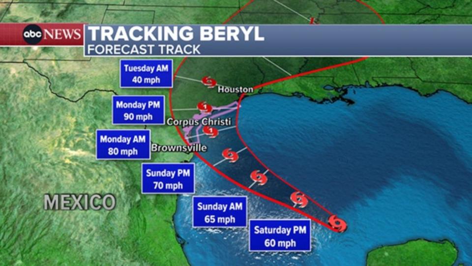
The track from the National Hurricane Center takes Beryl towards the Texas coast by late Sunday night into early Monday, likely as a strong Category 1 Hurricane.
Currently, the most likely landfall location is around Matagorda Island, just east of Corpus Christi, but that will likely need to be adjusted as the storm’s track becomes more "fine-tuned" in the next day or so.

