Beryl tracker: See Sunday's forecast path for Texas and spaghetti models
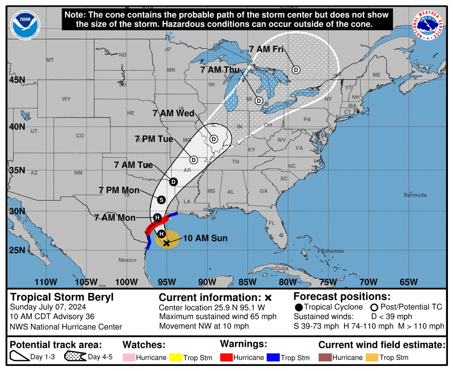
Tropical Storm Beryl is expected to strengthen Sunday in the Gulf of Mexico and make landfall along the Texas coast as a hurricane early Monday, according to the National Hurricane Center.
AccuWeather meteorologist Carl Erickson warned of strong winds when the storm comes ashore: "Winds of a Category 1 hurricane range from 74 to 95 mph and will down trees, cause widespread power outages and significantly damage property. Power outages can last for days to weeks in the hardest-hit areas."
Remnants of the hurricane are expect to travel as far north as Detroit, Michigan.
Sunday live updates: Hurricane forecasters warn Beryl will strengthen before slamming into Texas
Over the weekend, hurricane, tropical storm and storm surge watches and warnings were put in place for the coast of Texas.
Beryl storm tracker
This forecast track shows the most likely path of the center of the storm. It does not illustrate the full width of the storm or its impacts, and the center of the storm is likely to travel outside the cone up to 33% of the time.
Beryl spaghetti models
Illustrations include an array of forecast tools and models, and not all are created equal. The hurricane center uses only the top four or five highest-performing models to help make its forecasts.
Atlantic storm tracker
Contributing: Mike Snider and Doyle Rice USA TODAY; Jennifer Sangalang and Cheryl McCloud, USA TODAY NETWORK - Florida
Julia is a trending reporter for USA TODAY. She has covered various topics, from local businesses and government in her hometown, Miami, to tech and pop culture. You can connect with her on LinkedIn or follow her on X, formerly Twitter, Instagram and TikTok: @juliamariegz
This article originally appeared on USA TODAY: Beryl path tracker, spaghetti models: Follow the storm Sunday

