Beryl's lingering impacts to reach southern Ontario and Quebec this week
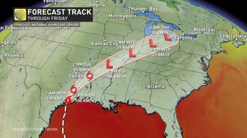
Beryl has made its third and final landfall as a Category 1 hurricane early Monday morning near Matagorda, Texas.
The storm, which has set three new records in its lifespan, has left a path of mass destruction through many Caribbean islands after churning through the Caribbean Sea as a major hurricane.
After making landfall over Mexico's Yucatan Peninsula on Friday, Beryl weakened into a tropical storm. It did, however, get refuelled by the Gulf of Mexico's warm waters and regained its hurricane status before it made landfall on the Texas coast on Monday.
Beryl will begin to quickly weaken as it moves inland on Monday while still bringing significant rainfall and a flood risk to Texas.

On Tuesday, only a low-pressure system will remain of the historic storm. By the time the low reaches the Mississippi Valley, an upper-level trough in the atmosphere over the central states will capture and send the low to southern Ontario and Quebec.
Check out The Weather Network’s hurricane hub for all the latest on storms near Canada and around the world
Southern Ontario & Quebec feels Beryl's remnants on Wednesday and Thursday
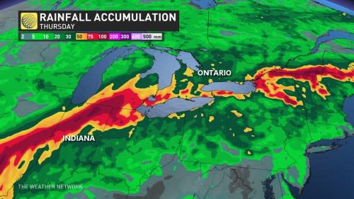
The earliest we can expect this moisture-packed low to reach the provinces is on Wednesday morning. Quebec can expect to see rainfall early Wednesday afternoon. It will file in from the south, through the Ohio Valley (the area surrounding the Ohio River), over Lake Erie, and move northward in waves through Thursday.
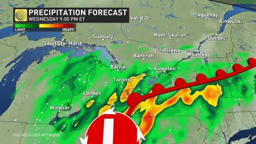
While driven by an upper-level trough, at the surface, the system will send a warm front through southern Ontario and Quebec. Around this front is where we expect to see the heaviest rain fall, as well as the risk of thunderstorms.

At this time, it's too soon to give precise rainfall totals for the provinces, but localized forecasts are expected to exceed 50 mm through Thursday. There is also a degree of uncertainty as to where the most rainfall will be. Currently, computer models are suggesting the 401 corridor may be the subject to the highest totals, but this could change leading up to the event.
DON'T MISS: Canadian Red Cross launches appeal to help people impacted by Hurricane Beryl
It can be easy to think that southern Ontario and Quebec is going to be struck by a hurricane-force storm when we say that the remnants of Beryl will reach the provinces. We can assure you, though, that that is not the case. Hurricanes need warm oceanic water to sustain themselves and will deteriorate rapidly when starved of that fuel.
By the time this system reaches southern Ontario and Quebec, it won't be a hurricane anymore; it won't even be a tropical depression by then, for that matter.
What we will see is a tropical moisture-laden low-pressure system. The main risks presently with this system in Ontario and Quebec will be heavy downpours, the risk of thunderstorms, and localized flooding.
The localized flooding from heavy downpours could also cause a significant amount of storm water runoff to make its way into Lake Ontario, raising the lake's pollution levels.
Not the first time
This isn't the first time Ontario and Quebec has felt the lingering impacts of a tropical system.
Hurricane Fran's impacts were felt in southern Ontario in September of 1996 when the then-tropical depression dumped 66.4 mm of rain at the Toronto Pearson International Airport.
SEE ALSO: Beware! These dangerous plants are found in Canada
Ike in September of 2008 and Sandie in October of 2012 are also prime examples of storms slamming Ontario with their lingering fury.
It's not just southern Ontario that has been impacted by once-tropical systems, too. In May of 2018, Alberto's remaining tropical depression crossed over Manitoulin Island and in June of 2020, Cristobal's tropical remnants made its way over Lake Superior, slamming Sault Ste. Marie with heavy rain and wind through the night.
Stay with The Weather Network for more forecast information and updates on your weather across Ontario and Quebec.

