Black and white patterns: Dots on old city maps show the damage developers did to KC
One night in 1961, I drove to a meeting not as a reporter for the Kansas City Star — though I was one — but as a hopeful participant in Housing Opportunities Made Equal (HOME).
HOME was a pitiful little group, a dozen or so casually dressed folks seated on folding chairs in a storefront building along Broadway near 35th Street. I already knew something about segregation in the city. I ate lunch daily at the jolly M&O Bar, one block north of the Star building at 18th and Grand.
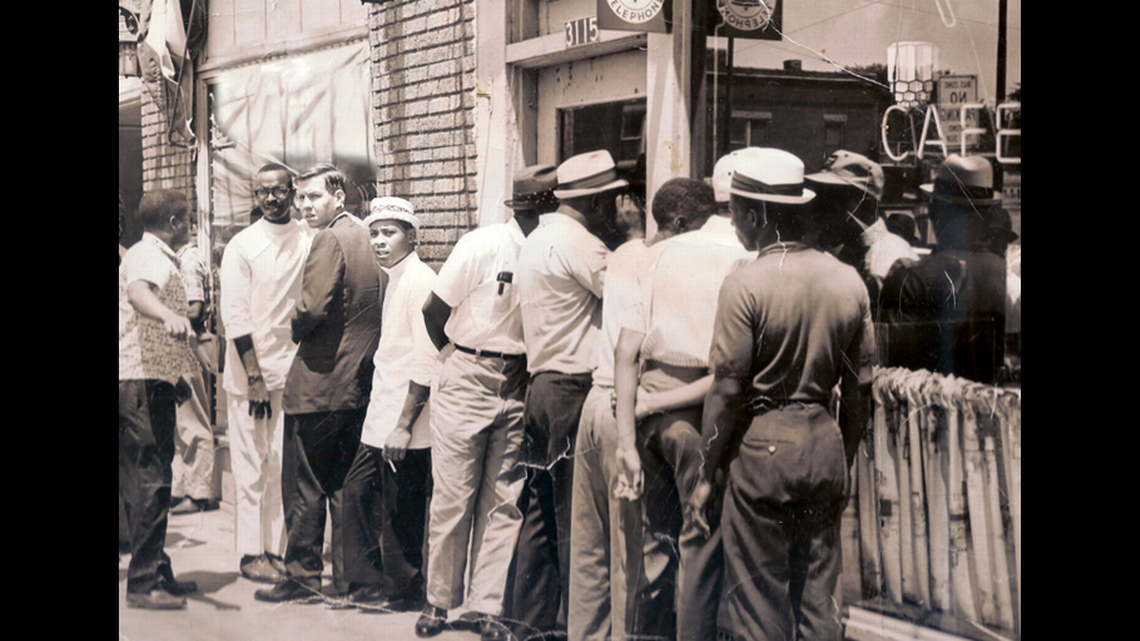
Virtually no restaurants here then served Black people. Owners of the M&O were so kind that in their brick south wall they had created a rectangular opening through which burgers could be purchased by black customers, who then sat on the sidewalk to eat — rain or shine, winter or summer. Cozy inside the bar, we beer-quaffing Star staffers often debated this system.
I was on the change side. My previous newspaper job in 1956 had been on the Guthrie, Oklahoma, Daily Leader, where the editor one day wanted a photo publicizing the United Campaign charity drive. I returned with the image of a cute little Black boy showing off the red feather logo on his lapel.
“Them people don’t give to United Campaign!” my editor growled. “We can’t use that!”
Three years later I showed up that night at the HOME meeting for help in deciphering what was happening to Kansas City neighborhoods. Most white residents here were saying what a shame that Black people “crowd together” when they buy homes, causing racial turnover of neighborhoods.
Indeed, block by block, mile after mile, communities east of Troost avenue were suffering virtually complete change from all white to all Black. Schools turned over in the same way. This hurt not just Black families but also whites who might have chosen to stay in integrated neighborhoods but not in these swiftly changing ones. White flight slashed demand for housing there, causing values to fall disastrously.
In two decades from the 1950s through the 1960s, some 67,000 whites — equal to almost one-fifth of Kansas City’s entire white population — moved out of those southeast neighborhoods, scattering to Independence, Johnson County, Raytown, the Northland.
A remarkable new map created by the city of Kansas City shows the result by the 1970 census: orange dots each representing 25 black citizens are densely packed into southeast Kansas City east of Troost extending southward to Swope Park with only a scattering beyond, plus another dense concentration in northeast Kansas City, Kansas. Green dots represent white occupation, while blue dots signify other races.
Who caused this? It was “blockbusters,” so the fable went, sneaky guys who would sell one home on a block to a black family, thus driving out all whites — pure baloney, as I soon learned. It was at that meeting in 1961 when Harry Green, a pint-sized real estate broker soon to be my friend, told us how prestigious brokers and mortgage bankers had long barred home sales west of Troost Avenue to Black families. By walling off most of the Kansas City metro, they focused all such buying along a narrow southeastward corridor, directly forcing racial turnover.
This was also happening in other American cities. Between 1924 and 1950, the ethics code of the National Association of Realtors, with the Kansas City Board as member, prohibited its brokers from moving Black buyers into white communities. The clause requiring discrimination was not fully erased from the Realtor Code of Ethics until 1974.
I have a friend who wonders why Kansas City eliminated the revered name of J.C. Nichols from a boulevard and a gorgeous fountain on the Country Club Plaza. Didn’t Nichols build lovely neighborhoods? Indeed, the much-celebrated Nichols did that. Tragically, he also wrote racial covenants into deeds that forbade sales to Black people and Jews, not just for the present but also into the limitless future. The U.S. Supreme court later revoked the “future” aspect of the covenants.
Nichols was far from the only discriminator, but he certainly topped the list. He and others kept white neighborhoods white and elsewhere inflicted block-by-block racial turnover. They segregated the Kansas City metro area. That was the truth I first heard 63 years ago at the HOME meeting on Broadway.
Two years passed before I nerved myself and wrote the first Star series telling that tale. I so trembled at the feared backlash that my lead was confused and stumbling. Still, by stressing how racial turnover hurt whites as well as Blacks, I got the message across then and in many later stories, often working with trailblazing journalist Helen T. Gray, among the Star’s first Black writers.
Those stories helped a cause. When a city public accommodations ordinance came up for a vote in 1963, the Kansas City Real Estate Board actually endorsed the measure. Aided by a heavy Black turnout, it won enough white support that the ordinance passed into law with a slim 50.9% majority.
What with later federal legislation and American hearts (believe it or not) changing for the better, it’s a new world now as documented in a second amazing city of Kansas City map. Orange dots representing Black families are much less concentrated east of Troost, with a scattering of green (for white families) among them.
Orange dots for Black families spread out far to the southeast beyond Longview Lake, far to the southwest into Johnson and western Wyandotte counties.
We are, in other words, beginning to look like — and perhaps be — a truly American metropolis.
Contact the columnist at hammerc12@gmail.com.

