Beryl is the earliest Category 4 on record and Tropical Storm Chris forms in the Gulf of Mexico
MYRTLE BEACH, S.C. (WBTW) — In an unprecedented start to hurricane season, Beryl has intensified from a Friday tropical storm to a major Category 4 hurricane in less than 48 hours. Peak intensity is now expected at 130 mph before entering the Caribbean Sea.
This is highly unusual and ahead of schedule. According to NOAA, the typical time of the first hurricane is historically around August 11, and the first major hurricane on September 1.
For a system to “rapidly intensify” the winds must increase 30 knots (~35 mph) in 24 hours. As of 4 p.m. yesterday, Beryl’s winds were 75 mph and have increased 45 mph to 130 mph.
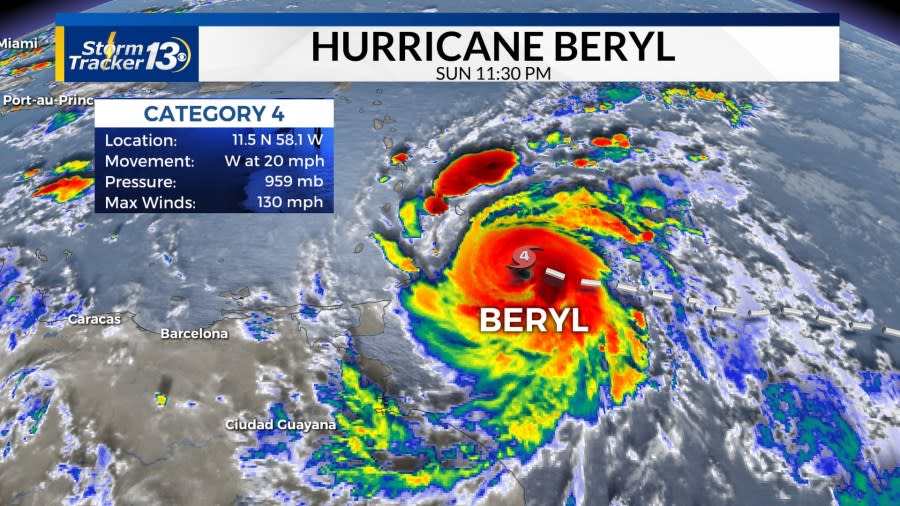
Beryl currently has winds of 130 mph. Beryl, (along with another area of interest behind it), is following the edge of an expansive, strong high pressure over the central Atlantic and across the eastern United States. Due to this, there is no threat to the Carolinas, at the moment, because the ridge is keeping the trajectory west. By the end of the work week, Beryl will be close to entering the Gulf of Mexico, and from there its exact path is unknown. European ensemble models are favoring another landfall in Mexico, but a direct impact on the Gulf Coast is not out of the question.
Beryl will be weaker once it is in the Gulf of Mexico, but that does not mean it won’t re-strengthen. A US landfall is not out of the question. Texas and the Gulf Coast will be on high alert next weekend.

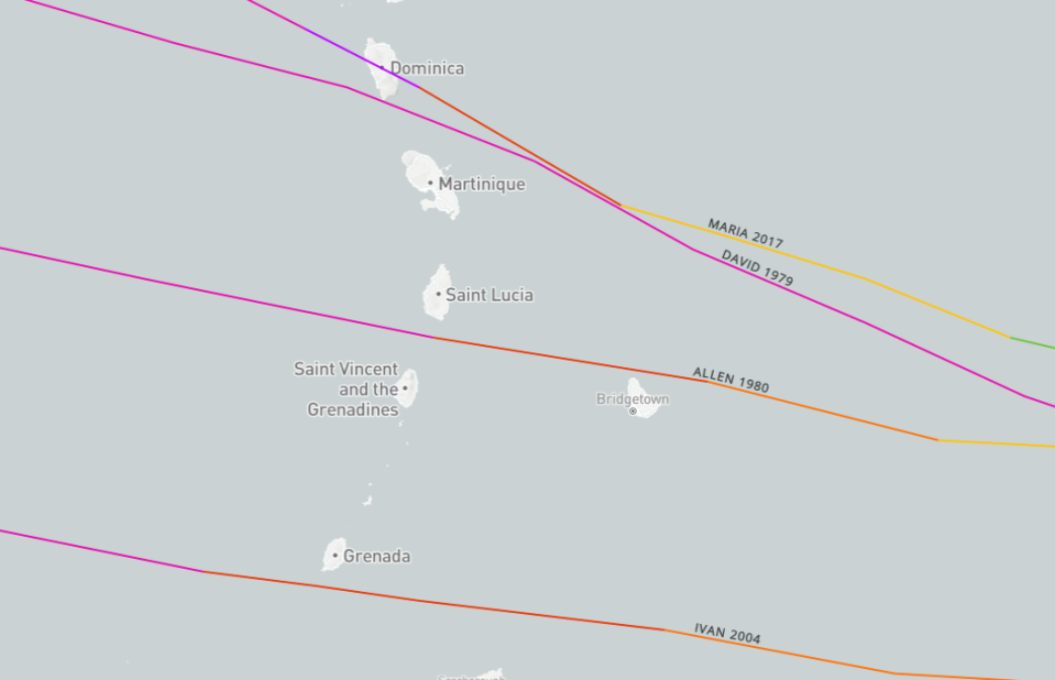
A hurricane warning is in effect for Barbados, Saint Lucia, Saint Vincent, and Grenada. The system is moving quickly but rainfall estimates are at 4-6 inches with 10 inches in isolated areas with tropical storm-force winds (39 mph or more) arriving tonight.
The last major hurricane to hit the Windwards Islands was Hurricane Maria in 2017 which was a direct hit for Dominica. Ensemble plots are confident the center will be south of Dominica and pass between St. Vincent and Grenada which would be a path most similar to Ivan (2004) and Allen (1980).
Beryl is an unprecedented system. It is the strongest June hurricane on record and only the third major hurricane on record for June (Alma 1966 & Audrey 1957). It will be the only major hurricane in June to originate in the MDR. Lastly, it will be the earliest Category 4 hurricane ever with the current record of July 5, 2005 (Dennis).
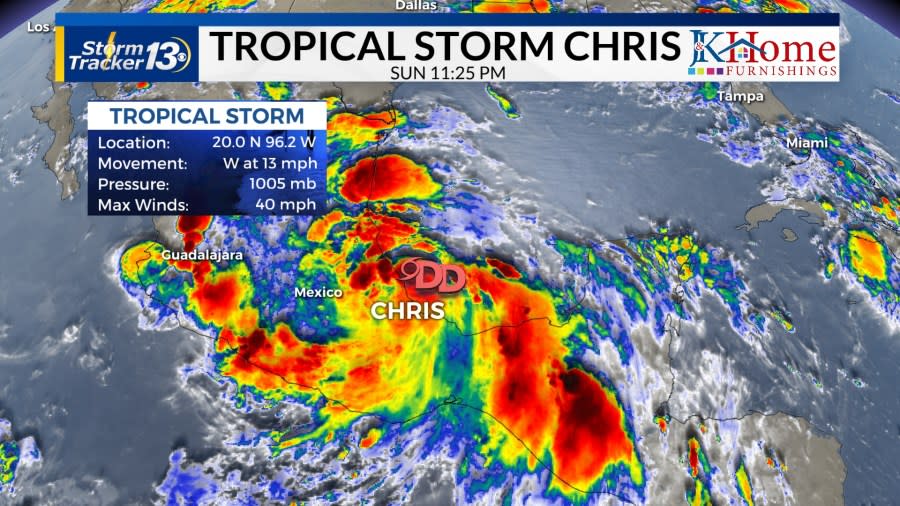
Tropical Storm Chris formed out of Tropical Depression Three in the Gulf of Mexico around 11 p.m. Sunday. Winds are sustained at 40 mph and it organized quickly throughout the day.
Landfall is expected overnight and early Monday morning as the center of circulation is less than 50 miles offshore. There is not much difference between a 35 mph storm and a 40 mph storm. 4-6 inches of rain with isolated communities seeing higher totals. Some of these locations are the same ones that were saturated by Tropical Storm Alberto. There could be more flooding and mudslides.
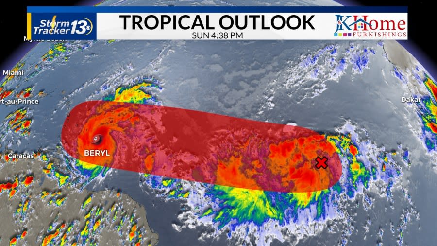
Another area with a high chance, 70%, of developing in the next week is located several hundred miles east of Beryl in the main development region. Again, June storms do not usually form in the tropical Atlantic but off the United States East Coast or in the Gulf of Mexico. Ocean temperatures in the tropical Atlantic are more than 3 degrees above average and temperatures are typical of September.
This area of low pressure will follow Beryl’s path. Beryl has disrupted the warm ocean because of its strength so there will not be as much fuel in this area. At the moment, it is forecasted to enter the Caribbean Sea on Wednesday. The GFS highlights this area as a named storm possibly as soon as Tuesday, the latest European model does not develop this. Both show a weak system.
Copyright 2024 Nexstar Media, Inc. All rights reserved. This material may not be published, broadcast, rewritten, or redistributed.
For the latest news, weather, sports, and streaming video, head to WBTW.

