California wildfire maps show you where fires are burning. See our list.
As California's wildfire season intensifies, the need for up-to-date information is critical.
Several organizations offer online maps that can help Californians figure out how far they are from the nearest fires and other significant information.
When using these sites, readers should be careful about making interpretations and note that geographical data is often delayed, so the maps may not represent a real-time look at what's burning that second.
Follow instructions from local law enforcement and firefighting officials who are on the ground.
Keeping that in mind, here are several maps that could be helpful for visualizing what areas are burning.
Note to readers: This report is based on a Record Searchlight article that initially published in 2021. We've made it free as an important public service to our North State communities. If you are able, help power local journalism by subscribing to the Record Searchlight/Redding.com or giving the gift of a subscription to someone you know. Your support goes a long way in helping us provide meaningful, in-depth coverage on issues that matter to you.
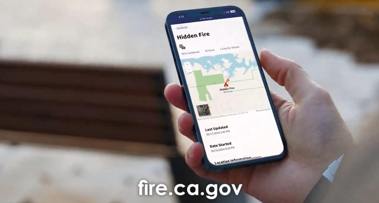
Cal Fire incident map
This is the official incident map for the California Department of Forestry and Fire Protection. The map provides details about all major fire incidents in the state, such as the fire's location, size, containment and which agency is managing the response.
On the left side of the map, you can adjust layers so that the map will show: active fire perimeters, county lines and locations under a red flag warning, smoke and haze forecasts and past wildfires going back five years
The map also includes live video feeds of ongoing wildfires in partnership with ALERTCalifornia, a public safety program based at the University of California, San Diego.
It also features updates on wildfire acreage and containment, incident maps, evacuation information, and aircraft flight paths.
Cal Fire provides fire protection to 31 million acres of California's wildlands and provides emergency services in 36 of the state's 58 counties.
More here: fire.ca.gov/incidents
InciWeb map
InciWeb is an interagency website led by the U.S. Forest Service. Readers might notice some Cal Fire-managed incidents don't appear on the map, and that's because InciWeb is primarily used by federal wildland fire agencies, such as the USDA Forest Service and Department of Interior agencies, including the National Park Service, Bureau of Land Management, U.S. Fish and Wildlife Service and Bureau of Indian Affairs.
This FAQ provides more information. It is hosted on the site for the National Wildlife Coordinating Group. The map distinguishes between wildfires and prescribed fires. The layers of the map can also be adjusted to show red flag areas.
InciWeb can be used for floods and mudslides, according to a U.S. Forest Service spokesperson.
More here: https://inciweb.nwcg.gov/
NASA Firms map
NASA's Fire Information Resource Management System map provides fire data within three to five hours thanks to satellite detection. For those who want to spend time exploring the page's features, the map also comes with tutorials and a page dedicated to frequently asked questions.
More here: https://firms2.modaps.eosdis.nasa.gov/map/#d:2020-08-23..2020-08-24;@0.0,0.0,3.0z
National Interagency Fire Center map
This map, the Enterprise Geospatial Portal, is provided by the Boise-based National Interagency Fire Center. The map shows fire perimeters and satellite-identified hotspots.
The page also has a helpful "briefing mode" that allows readers to see a major fire's containment, estimated cost and number of personnel assigned to it.
More here: https://maps.nwcg.gov/sa/#/%3F/%3F/38.6334/-121.448/9
Air quality map
The map by AirNow.gov shows how pollutants like smoke from wildfires are affecting air quality.
The map can help you find out which areas of the state and country have more or less smoke. If you visit the site's homepage, you can enter your zip code and another map will generate showing air quality in your specific area.
More here on the Air Quality Index: https://data.redding.com/air-quality-index/
Traffic cameras map
This traffic cameras map provides traffic reports and live views from traffic cameras in regions in California and across the country.
California wildfire, smoke map
This map provides wildfire and red flag warnings. It uses data that is updated hourly based on input from several incident and intelligence sources. The sources are the Wildland Fire Interagency Geospatial Service(WFIGS), Canadian Interagency Forest Fire Centre (CIFFC), NOAA Office of Satellite and Product Operations.
Outdoor cameras map
Apart from maps, readers can also find outdoor cameras that survey areas across California and parts of the West.
For cameras in areas in Washington, Idaho, Oregon, Nevada, California's Greater Tahoe region, Nevada and Arizona, go to alertwildfire.org.
For cameras in most of California, go to alertcalifornia.org.
The Victorville Daily Press contributed to this report.
This article originally appeared on Redding Record Searchlight: See where California wildfires are burning with these maps

