Debby landed as a hurricane and became a tropical storm; here's what makes the difference
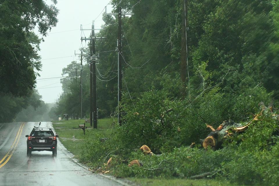
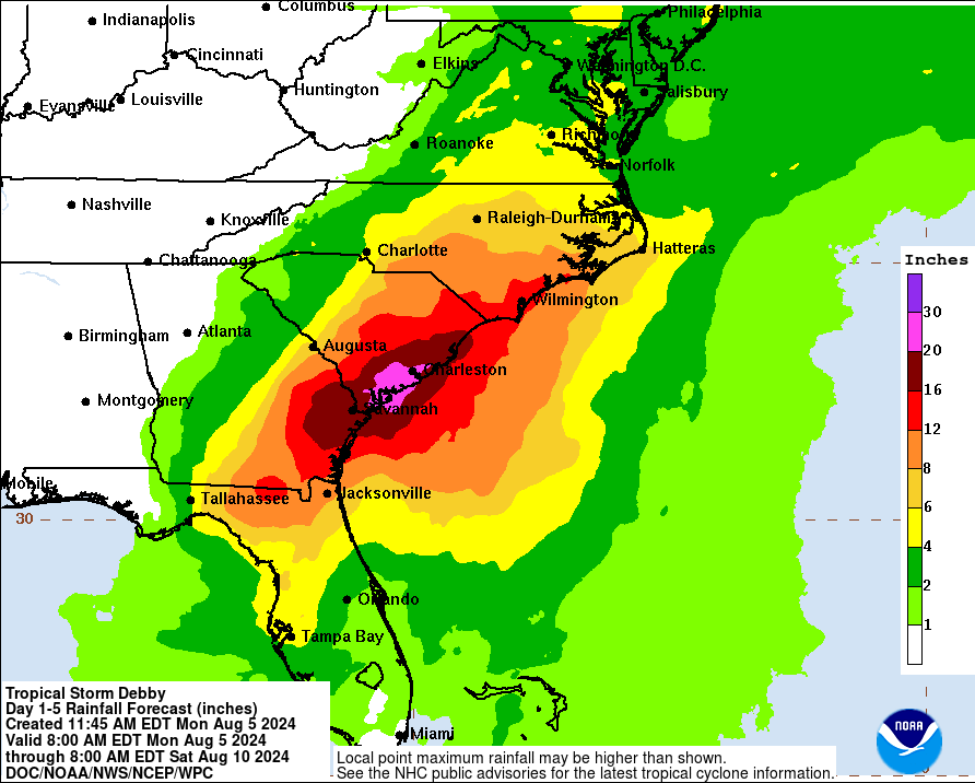
South Carolina's coast has received record amounts of rainfall in the wake of Tropical Storm Debby, which made landfall as a Category 1 hurricane in Steinhatchee, Florida early Monday morning before weakening into a tropical storm again.
But what makes a hurricane different from a tropical storm? Here's how to tell the difference, along with some other key things to know as the Atlantic hurricane season approaches its traditional climax.
What is a hurricane?
Hurricanes are tropical cyclones that form in the warm waters near the equator.
Tropical cyclones have different names based on their region. In the Northern Hemisphere, tropical cyclones are categorized by wind speed. Tropical cyclones with wind speeds over 74 miles per hour are called hurricanes.
Following a pre-existing disturbance, such as Easterly Waves or a cluster of thunderstorms, the first stages of a tropical cyclone can begin.
To form, hurricanes need waters of at least 80 degrees Fahrenheit. Warm water rises into the air, and as it rises, it creates lower air pressure beneath it. Nearby air rushes in, and the process repeats – the air warms, rises, and then begins to cool. As that water vapor cools, it begins to condense and forms clouds.
But not all clouds are the same. Hurricanes are made up of thunderstorm clouds, or cumulonimbus clouds. Clouds are classified by different Latin root words that provide insight into what impact they might have on the weather. "Cumulo" means heap, and "nimbo" means rain or precipitation. Together, it's a heaping rain cloud.
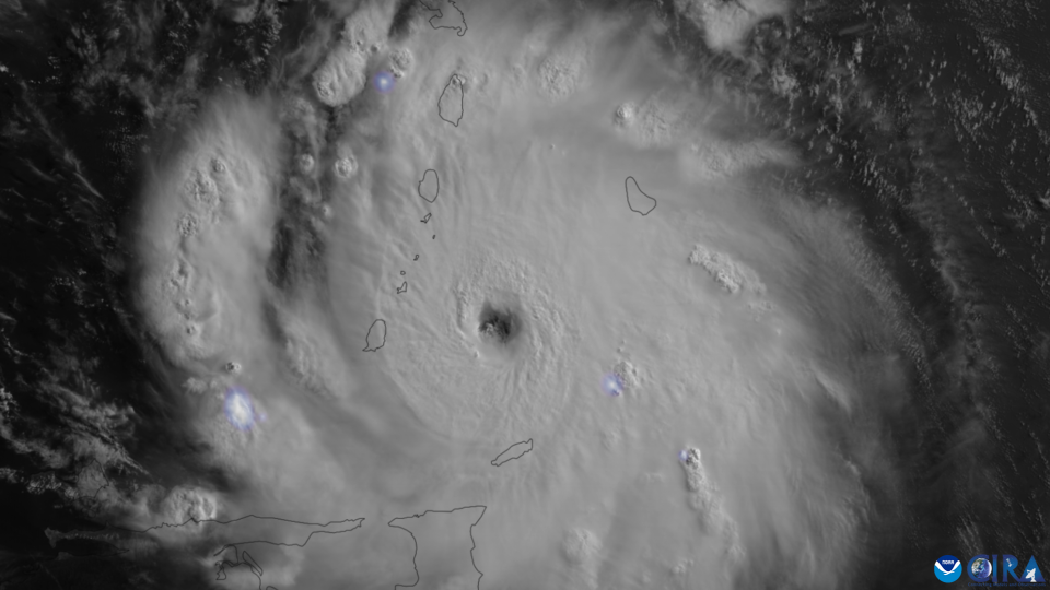
The cumulonimbus clouds form, and they begin to move in a spiral. The surface winds move continuously in a circle. Meteorologists call this "closed low-level circulation." In the Northern Hemisphere, these rotations are always counterclockwise due Earth's rotation on its axis.
That's what makes up the core of the hurricane: An organized spiral of storm clouds.
What are the different parts of a hurricane?
Hurricanes are made up of three main components:
The "eye," or the center of the hurricane. It is characteristically cloud-free and calm.
The "eyewall," which surrounds the eye. Here, the winds are the strongest.
The "rainbands," or curved bands of storm clouds that trail away from the eye in a spiral formation.
As the surface winds rotate, air sinks in the center of the clouds and forms the recognizable eye of the hurricane. The center is calm and clear. The winds in the eye are typically 15 miles per hour or less, and the average eye is about 20-40 miles wide.
Storms typically develop an eye at windspeeds of 74 miles per hour or greater. The eyewall forms around the eye, and rainbands form around the eyewall. Taking all three components into account, the average hurricane is roughly 300 miles wide, though each storm can vary.
What makes a hurricane different from a tropical storm?
Hurricanes and tropical storms are categorized by wind speeds.
Tropical cyclones can either be a depression, a storm or a hurricane. The Saffir-Simpson Hurricane Wind Scale gives us the widely referenced "categories" of storms:
Tropical depression: A tropical cyclone with winds that are 38 miles per hour or less
Tropical storm: A cyclone with wind speeds between 39-74 miles per hour
Hurricane: A cyclone with wind speeds higher than 74 miles per hour. A hurricane is considered "major" once it reaches wind speeds of 111 miles per hour.
Once storms reach hurricane status, they're divided into categories:
Category 1: 74-95 mph winds
Category 2: 96-110 mph winds
Category 3: 111-129 mph winds
Category 4: 130-156 mph winds
Category 5: 157 mph winds or higher
The higher the wind speed, the more dangerous a hurricane is likely to be. Damage can come from the severe wind, but it can also come from storm surge, or an abnormal rise in water that can cause catastrophic flooding.
Hurricanes are fed by warm ocean water. Once they make landfall, hurricanes weaken as they head further inland.
Another factor that can help weaken hurricanes is wind shear or a change in the speed or direction of wind. A strong vertical wind shear can help blow the tops off of some of the cumulonimbus clouds and weaken the hurricane.
This year, because scientists expect a La Niña to form, wind shear will likely be weaker in the Southeast. Historically, weaker wind shear has led to increased hurricane activity in the Atlantic. Because of this year's anticipated La Niña and warmer ocean temperatures, the National Oceanic and Atmospheric Administration predicted a more active than normal hurricane season for 2024.
In 2024, NOAA predicted 17-25 named storms, or storms with winds at 39 mph or higher, compared to the average 14. Of those storms, 8-13 are expected to become hurricanes, compared to the annual average of seven, and between four and seven are expected to be major hurricanes, compared to the average of three.
Scientists also believe that warming global temperatures from greenhouse gases could lead to more intense hurricane seasons.
Read more: Cool waters, the jet stream and La Niña: What South Carolina could see this winter
How Debby stacks up and how South Carolina will be impacted
While Debby made landfall as a hurricane, it is now a tropical storm.
Debby formed first as a tropical depression near Eastern Cuba before making landfall as a Category 1 Hurricane in North Florida. Debby came ashore in Steinhatchee, Florida and had sustained winds of roughly 80 miles per hour.
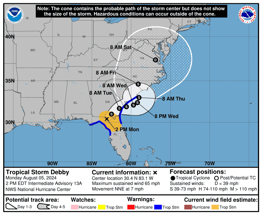
Late Monday night, Debby was still moving slowly across the Southeast and was located about 35 miles west of Brunswick, Georgia. Meteorologists predict Debby's center will hit South Carolina's coast on Thursday, though impact from the storm has already begun.
According to the most recent NWS advisory, Debby is currently experiencing sustained winds around 45 mph, but could weaken over the next few days. However, after returning to the ocean, the storm could strengthen again before making landfall in South Carolina.
Gov. Henry McMaster declared a state of emergency in South Carolina on Sunday. President Joe Biden approved the declaration on Monday evening.
The National Weather Service National Hurricane Center in Miami first issued an advisory on Aug. 2 regarding a disturbance in the Atlantic Ocean about 90 miles east-southeast of Camaguey, Cuba and 420 miles southeast of Key West, Florida. Initially, Debby had winds of about 30 miles per hour.
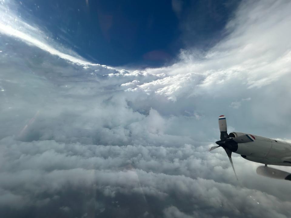
Debby began as a tropical depression, or a tropical cyclone with winds of 38 miles per hour or less. Debby was upgraded to a tropical storm on Saturday evening, reaching winds of 40 miles per hour about 100 miles southwest of Key West, Florida. The National Oceanic and Atmospheric Administration sent hurricane hunters, along with the Air Force Reserve, on Saturday night to investigate the storm.
By Sunday morning, Debby had reached wind speeds of 65 miles per hour and was expected to “strengthen rapidly” into a hurricane. Debby became a hurricane late Sunday night after reaching winds of 75 mph.
Coastal South Carolina is already seeing Debby's impact, though the center of the storm is not expected to reach the coast until Thursday. Areas along the coast are under a tropical storm warning from the National Weather Service, along with storm surge warnings. Other areas of South Carolina are under tornado warnings and watches. For updated information on local weather advisories, check the NWS website.
In South Carolina, Monday's rainfall ranged from 1.2 inches at a station in Mount Pleasant to nearly eight inches at a site in Beaufort County.
Debby marks the second tropical cyclone to reach hurricane status in the Atlantic so far this year, following Hurricane Beryl. Tropical Storms Alberto and Chris have rounded out the season, which is expected to increase in intensity throughout August. Debby is the first tropical cyclone to affect South Carolina in 2024.
Most recently, South Carolina saw impacts from Hurricane Idalia in August 2023 and Tropical Storm Ophelia in September 2023.
Sarah Swetlik covers climate change and environmental issues in South Carolina's Upstate for The Greenville News. Reach her at sswetlik@gannett.com or on X at @sarahgswetlik.
This article originally appeared on Greenville News: What is the difference between a hurricane or a tropical storm?

