Earliest Ever Cat 5 Hurricane Now Threatening to Hit the U.S.
Hurricane Beryl has been upgraded to a “potentially catastrophic” Category 5 storm as it rolls through the southeastern Caribbean on a path that some models project may see it eventually make landfall in Texas.
It’s a bad omen for what’s already expected to be a more active than usual hurricane season, which some forecasts estimate may go down as the busiest ever thanks to abnormally high ocean temperatures in the Atlantic.
If Beryl were to strike the Lonestar State, models say it’d likely do so Sunday or early next week. There is some good news for Texans, however—Beryl is expected to be significantly weaker by then after likely plowing across Jamaica and through Mexico’s Yucatan Peninsula.
12z spaghetti and intensity models for #Beryl. Two things to note
1) most models are now firmly in the Texas camp 🤔
2) intensity models seem to be breaking into 2 camps. One where #Beryl deals with some shear/land and then stabilizes, and one where it is destroyed. pic.twitter.com/QMwMUjdLmP— Florida Tropics (@FloridaTropics1) July 2, 2024
Still, Beryl had set a number of records before it made landfall in Grenada on Monday with 160 mph winds: as the earliest Category 4 Atlantic storm, the earliest Category 5, only the second ever declared in July, and the first major hurricane east of the Antilles in June. It is also one of the the fastest-developing storms on record, taking just 48 hours to go from unnamed depression to hurricane force—adding to the alarming trend of storms “rapidly intensifying” that experts say will only become more common as ocean temperatures become warmer each year.
Heat Wave Torturing the U.S. Will Get Worse in Some States
Its speed and force have shocked meteorologists, who are already predicting twice as many storms as usual for this year’s Atlantic hurricane season, which officially runs from June 1 to November 30.
More concerning for many, though, is its cause: Beryl is being fed by waters in the mid-80s Fahrenheit, almost 4 degrees higher than normal and equal to the kind of temperatures usually seen at the peak of the hurricane season in September. Those record temperatures, defying existing models, are forcing scientists to reexamine their basic understanding of global warming and its likely trajectory.
“Beryl is unprecedentedly strange,” said Weather Underground co-founder Jeff Masters, a retired U.S. government ‘storm chaser.’ “It is so far outside the climatology that you look at it and you say, ‘How did this happen in June?’”
Beryl made landfall Monday in the Grenadian islands of Carriacou and Petite Martinique, still officially a Category 4 storm. “In half an hour, Carriacou was flattened,” Grenada Prime Minister Dickon Mitchell said. At least one person was killed, but officials said they would have to wait until the storm had passed entirely before sending up drones to capture the extent of the damage.
The United Nation’s climate chief, Simon Stiell, told CNN on Tuesday he hadn’t been able to contact his family on Carriacou since Beryl’s landfall. He said the island had been “flattened,” and that emerging images “show a very, very distressing signal.”
An enraged Stiell attributed the storm’s extreme strength so early in the summer to global warming.
“This is a direct consequence of global heating that is fueling these intense hurricanes,” he said.
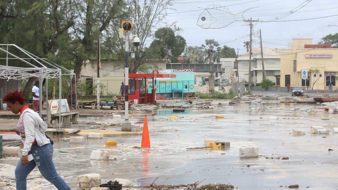
Beryl continued its devastating trail through neighboring islands in the eastern Caribbean—including Grenada itself, St Vincent and the Grenadines, and Barbados—downing power lines, snapping banana trees in half, and ripping tin roofs off island shacks.
“Beryl is now a potentially catastrophic Category 5 hurricane,” the U.S. National Hurricane Center said, warning that it would bring life-threatening winds and a storm surge to Jamaica later this week.
Colorado State University hurricane researcher Phil Klotzbach told the AP Beryl was “a harbinger potentially of more interesting stuff coming down the pike.”
“Not that Beryl isn’t interesting in and of itself, but even more potential threats and more—and not just a one off—maybe several of these kinds of storms coming down later,” he added.
Residents across the eastern Caribbean were boarding up windows, stocking up on food, and topping up fuel supplies as the storm approached.
But at the Chillin’ restaurant in Kingston, Jamaica, waiter Welton Anderson told Reuters he felt calm despite the hurricane’s approach. “Jamaicans wait until the last minute,” he said. “The night before or in the morning, the panic sets in. It’s because we’re used to this.”
Get the Daily Beast's biggest scoops and scandals delivered right to your inbox. Sign up now.
Stay informed and gain unlimited access to the Daily Beast's unmatched reporting. Subscribe now.

