Eight of the strangest hurricanes we’ve ever seen
Hurricanes are a raw expression of our atmosphere’s power. These immense storms can grow hundreds of kilometres wide and wreak havoc as they swirl ashore with fierce winds and tremendous flooding.
While hurricanes are often notable for the destruction they leave behind, some are memorable because of how odd they were. There’s a hurricane that travelled more than 10,000 km during its lifetime. Another formed in December and churned straight into the new year.
Here are some of the strangest hurricanes we’ve seen in the Atlantic and around the world.
Check out The Weather Network’s hurricane hub for all the latest on storms near Canada and around the world
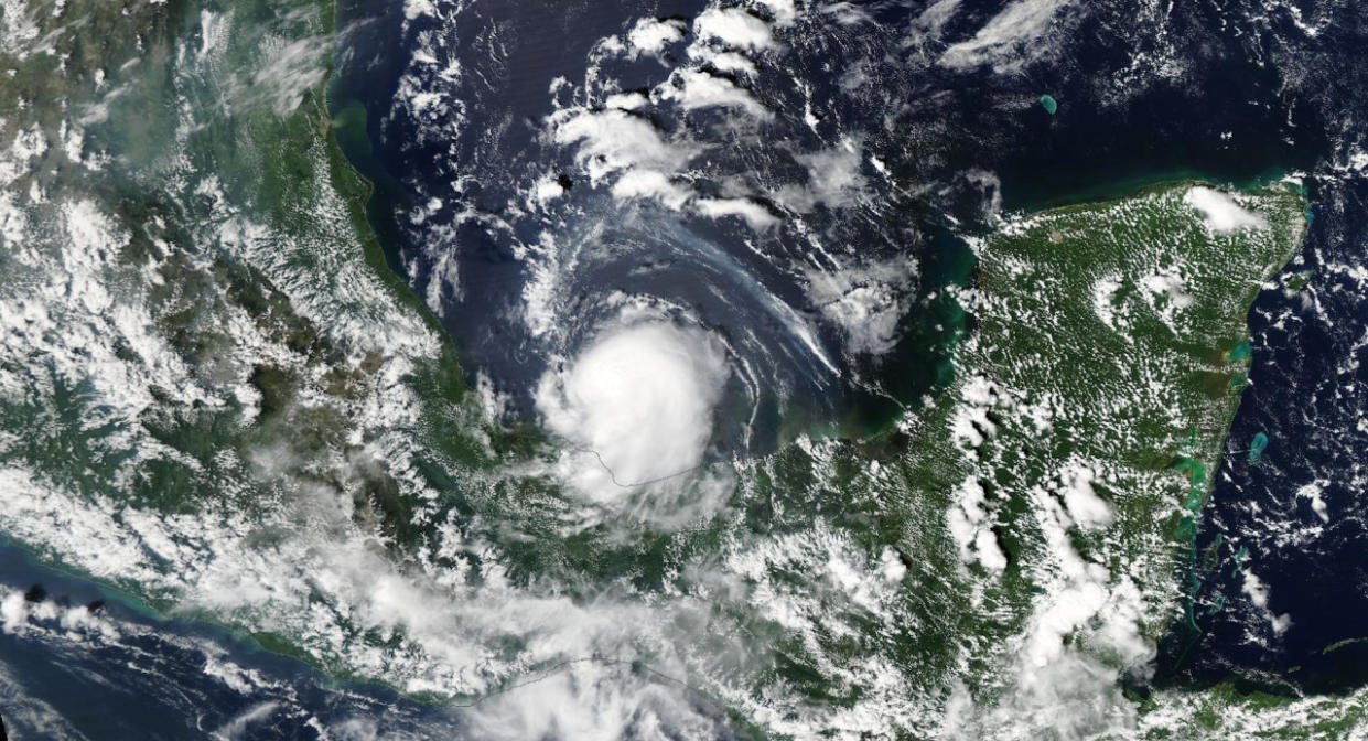
Hurricane Beryl defied the odds
The past is usually a good guide to follow when figuring out what a storm will do in the future. It’s exceptionally rare to get a powerful hurricane early in the season. Beryl didn’t get that memo.

DON'T MISS: How a mammoth hurricane rapidly intensifies in mere hours
The scale-topping Category 5 hurricane would’ve been a powerhouse for any time of the year. But the storm formed at the end of June 2024 and rapidly intensified to its maximum intensity by the first days of July, a first-of-its-kind feat in records stretching all the way back to 1851.
Cyclone Freddy survived for more than a month
It’s rare for a tropical cyclone to last for more than a week or two before it finally falls apart. But some storms just keep going, and going…
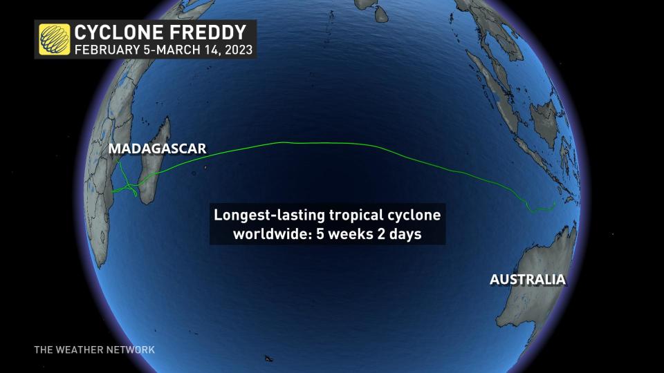
Cyclone Freddy formed off the northern coast of Australia on February 4, 2023, and survived for the next five weeks. The storm travelled the width of the Indian Ocean, making landfall in Madagascar before meandering off the eastern coast of Africa. At one point, Freddy strengthened to the equivalent strength of a Category 5 hurricane.
The World Meteorological Organization confirmed in 2024 that Freddy was the longest-lasting tropical cyclone ever observed.
WATCH: See Cyclone Freddy's historic journey from space
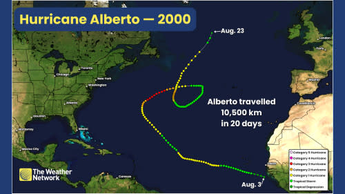
Alberto wore out its welcome in 2000
The Atlantic Ocean isn’t friendly to storms that manage to thrive on its warm waters. Prevailing winds and plentiful landmasses spell eventual doom for storms after a week or two at most.
MUST SEE: How hot water fuels the world’s most powerful hurricanes
But there was one storm back in 2000 that managed to survive for 20 full days. Hurricane Alberto slowly trekked from the western shores of Africa toward the northern reaches of the Atlantic's shipping lanes. The storm grew into a major hurricane before completing a large loop in the centre of the ocean.
Alberto travelled more than 10,500 km during its 20-day journey through the ocean, becoming one of the longest-tracked storms ever observed over the Atlantic basin.
Tropical Storm Julia formed over land
A short-lived storm in 2016 turned out to be one of the only systems ever observed to have formed over land. Forecasters watched a disturbance develop into a tropical depression just as it made landfall in eastern Florida near Cape Canaveral in September 2016.
The system’s centre remained just inland as it moved north. Sufficient humidity and proximity to the ocean allowed the system to grow from a tropical depression into Tropical Storm Julia while its centre was over land. It moved offshore and fell apart not long after its Florida vacation.
Hurricane Sandy was mind-bogglingly large
Hurricane Sandy slammed the northeastern U.S. around Halloween 2012 as one of the worst storms in the region’s history. The storm began transitioning from a tropical cyclone to an extratropical cyclone as it approached landfall.
HURRICANE PREPAREDNESS: What you need in your kit
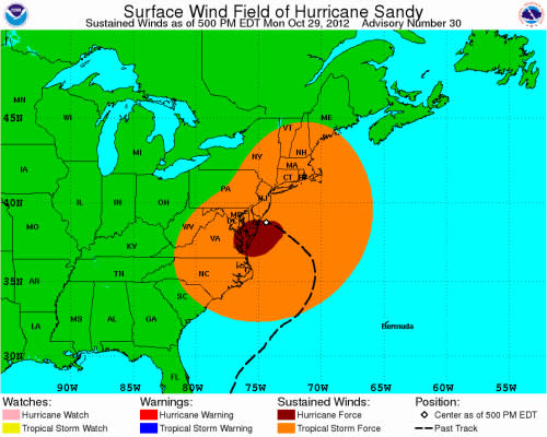
Hurricane Sandy's wind field on October 29, 2012. (NOAA/NHC)
This transition allowed the storm to spread its energy over a wide area instead of concentrating all of its fury in a tiny portion of the eyewall. As a result, the storm’s tropical storm force winds covered more than 1,600 km from Bangor, Maine, all the way down to Myrtle Beach, South Carolina.
WATCH: How Hurricane Sandy’s historic effects changed weather foreasting
Marco was the smallest storm ever observed
Let’s leap from the biggest Atlantic storm on record to the tiniest. Tropical Storm Marco formed in the southern Gulf of Mexico in October 2008. The storm rapidly organized and nearly developed an eye.
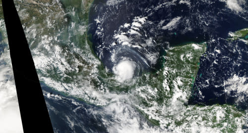
Tropical Storm Marco in the Bay of Campeche on October 6, 2008. (NOAA/NASA Worldview)
That wouldn’t be unusual if the storm were bigger than your average summertime thunderstorm.
Marco was the smallest tropical cyclone ever observed, with tropical storm force winds covering just 18 km from one end to the other. That’s about the same as the distance from downtown Toronto to Pearson Airport.
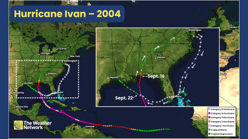
Ivan made a giant loop and returned to the Gulf
Hurricane Ivan lives in history as one of the most destructive storms to hit the northern Gulf Coast. The major hurricane fell apart after pushing inland, with its remnants producing a significant tornado outbreak as it tracked north toward Washington, D.C.
RELATED: Tropical systems don’t need a name to trigger devastating floods
Things started getting weird from there. Ivan’s remnants got swept off the Virginia coast and started moving south through the southwestern Atlantic Ocean. The disturbance then crossed west over the Florida Peninsula, crossing its own path in the Gulf of Mexico and reforming six days after it first made landfall.
Forecasters with the National Hurricane Center famously argued with one another over whether or not it truly constituted the same storm, but experts agreed that the system was a second wind for the newly reformed Tropical Storm Ivan.
Alice spanned two calendar years
Hurricane Alice made history in 1954 as the only hurricane ever observed to exist across two different calendar years. The storm beat the odds to form over the Caribbean on December 30, 1954, gradually strengthening as it tracked toward the Virgin Islands.
Alice eventually strengthened into a Category 1 hurricane by the turn of the new year, lashing the Greater Antilles with high winds before crossing into the open Atlantic where it would soon fizzle out.
The system was just one of a couple of named storms ever recorded during the month of January, and the only hurricane to form in December and last into January.
Header image courtesy of NOAA/NASA Worldview.

