Beryl pushes onto Windward Islands with catastrophic winds, storm surge
Hurricane Beryl continues to intensify as a high-end Category storm, bringing "catastrophic winds and life-threatening" storm surge onto the southern Windward Islands Monday, the U.S. National Hurricane Center (NHC) said.
A weather station at Grenada airport recently reported a sustained wind speed of 148 km/h and a gust of 194 km/h, while a unit in Saint Lucia recently documented a sustained wind speed of 83 km/h and a gust of 102 km/h.
Check out The Weather Network’s hurricane hub for all the latest on the active hurricane season ahead
Beryl swirled into history on Sunday when its maximum winds rapidly intensified to Category 4 status, the earliest such storm ever recorded in the Atlantic.
Beryl intensifies further, brings 'catastrophic' impacts
A hurricane warning is in effect for Barbados, St. Vincent and the Grenadine Islands, Grenada and Tobago as Beryl’s winds and rain continue to batter the region.

Beryl continues to produce catastrophic winds and life-threatening storm surge to the Grenadine Islands, Carriacou Island and Grenada.
"This is an extremely dangerous and life-threatening situation. Residents should not leave their shelter and remain in place through the passage of these life-threatening conditions," NHC said.
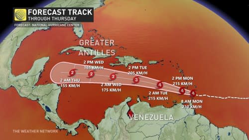
Reconnaissance aircraft found that Beryl’s winds increased back to Category 4 strength on Monday morning. Since then, it has strengthened even further, with sustained winds near 240 km/h, NHC said in its most recent update. It is nearing Category 5 status.
The worst conditions are expected here through the day Monday as the powerful hurricane crosses west into the Caribbean Sea. Destructive winds, life-threatening storm surge flooding, and torrential rains are expected along Beryl’s path.
RELATED: Hurricane forecasts are better today than ever before—here’s how
It will remain an extremely dangerous, major hurricane as its core moves through the Windward Islands into the eastern Caribbean, potentially threatening Jamaica as a weakened hurricane by Wednesday.
Anyone in the Caribbean should closely monitor the developments of this storm and heed the advice and orders of local officials.
One of the region’s earliest storms on record
Beryl wouldn’t be out of place as a powerful hurricane in the middle of hurricane season, but it’s unheard of to have such a powerful storm this early in the year.

It was the earliest we’ve ever seen a hurricane form in the tropical Atlantic Ocean.
The only other storms that formed this far east this early in the year were Hurricane Elsa in 2021 and an unnamed storm that hit Trinidad and Tobago in 1933. It’s worth noting that both 2021 and 1933 eventually ranked among the most active hurricane seasons on record.

Beryl is also the earliest Category 4 hurricane ever recorded in the Atlantic Ocean, beating by a week the record set by Hurricane Dennis back in 2005. The historic 2005 season saw Hurricanes Dennis and Emily peak at Category 4 and 5, respectively. Dennis reached major hurricane status on July 7, and Emily did so a week later.
The last time there was a major hurricane before the July 4th holiday was Hurricane Alma on June 8, 1966. Alma was also the earliest hurricane to make landfall in the U.S. since 1825.
MUST SEE: El Niño is over—but La Niña may arrive during peak hurricane season
Experts largely agree that we’re in for a very active Atlantic hurricane season in the weeks and months to come. Sea surface temperatures throughout the Atlantic are running several degrees hotter than normal, closer to what you’d expect in September than the end of June.
These abnormally hot waters will combine with the lower wind shear brought on by a developing La Niña in the eastern Pacific to foster extremely favourable conditions for tropical cyclone development through the peak of the season this fall.
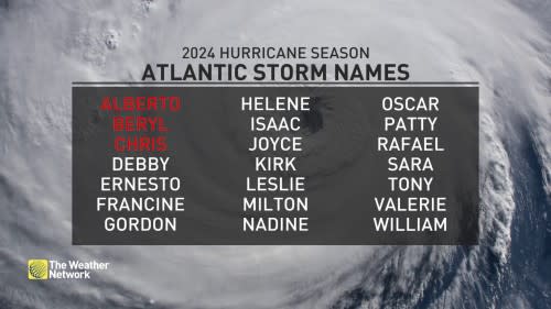
The latest seasonal outlooks call for as many as two-dozen named storms, which is far more than the 14 tropical storms we’d see during a typical Atlantic hurricane season.
Thumbnail courtesy of the National Oceanic and Atmospheric Administration (NOAA).
Stay with The Weather Network for all the latest throughout hurricane season.

