Flood watch issued as remnants of tropical system Beryl lift across the region
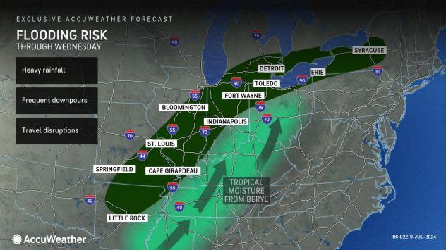
The potential of heavy rain continues to increase through Wednesday as the remnants of tropical system Beryl lift across the southern Great Lakes and Ohio River Valley, according to the National Weather Service.
Scattered showers and thunderstorms Tuesday.
The greater potential of heavy rainfall is Tuesday night into Wednesday afternoon.
"Confidence remains low on the exact track of this system and the resulting axis of heaviest rainfall. However, widespread amounts of 1 to 2 inches appears likely Tuesday night into Wednesday ... with locally higher amounts possible," according to the weather service's Hydrologic Outlook.
"Heavy rainfall could lead to areal flooding concerns and rises on rivers across the area during the middle and latter portions of this week. If higher precipitation amounts in the forecasted range occur, some river flooding would also be possible. A good deal of uncertainty persists regarding the track of this system, so stay weather aware over the next 24 to 36 hours and monitor forecast updates along with the potential for any flood watches and warnings."
A flood watch is in effect from 5 p.m. Tuesday to 5 p.m. Wednesday for Branch and St. Joseph counties, along with other areas in the region.
This article originally appeared on Sturgis Journal: Flood watch issued as remnants of tropical system Beryl lift across the region