Hurricane Season 2024: Beryl could form, but count on temperatures scorching South Florida
South Florida weather will sizzle this weekend with above normal heat and an eye on the tropics where the National Hurricane Center is watching three disturbances with one forecast to become Hurricane Beryl.
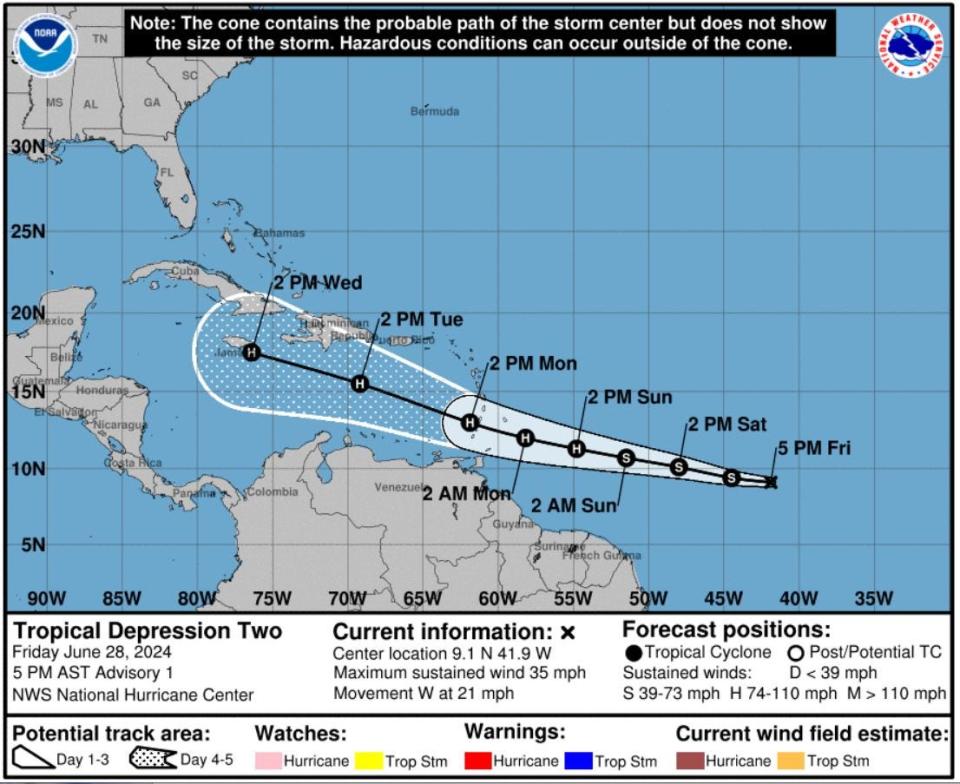
As of Friday afternoon, the center said Invest 95L had become Tropical Depression Two and was expected to reach tropical storm status over the weekend in the central Atlantic east of the Windward Islands. By Monday, the would-be Beryl could reach hurricane strength ahead of the islands of Barbados, Saint George's and Kingstown.
The official NHC forecast has it growing to a Category 2 hurricane by Tuesday with 105 mph winds.
"Development this far east in June is unusual, in fact, there have only been a few storms in history that have formed over the central or eastern tropical Atlantic this early in the year," wrote NHC senior hurricane specialist John Cangialosi in the 5 p.m. Friday forecast.
There is no immediate threat to the United States or Florida from the tropical disturbances, but Palm Beach County may find itself under another heat advisory after suffering heat index or "feels like" temperatures that were forecast to reach as high as 110 on Friday.
"There is a good chance we will issue another heat advisory Saturday as temperatures are similar and and heat index values seem to be similar or slightly higher than today (Friday)," said Anthony Reynes, a meteorologist in the Miami office of the National Weather Service. "For Sunday, we still have time to check on upcoming guidance and decide depending on how the forecast evolves."
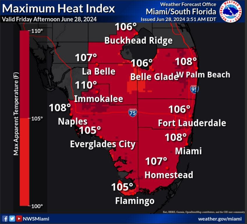
Saturday's high temperatures are forecast to be in the lower 90s for most of southeast Florida. That is expected to repeat on Sunday, which could make it a sweaty afternoon for the parade in Fort Lauderdale celebrating the Florida Panthers winning the Stanley Cup.
The parade starts at 11 a.m. at Riomar Street near the Hilton Fort Lauderdale Beach. It will end about a mile south at Fort Lauderdale Beach Park. Sunday's forecast also calls for a 60% chance of showers and thunderstorms with some beginning before 2 p.m.
While several tropical forecasters were calling for this week to be quiet, Mother Nature had other plans.
"The tropics are looking more like August than June," said FOX Weather hurricane specialist Bryan Norcross in his Hurricane Intel blog.
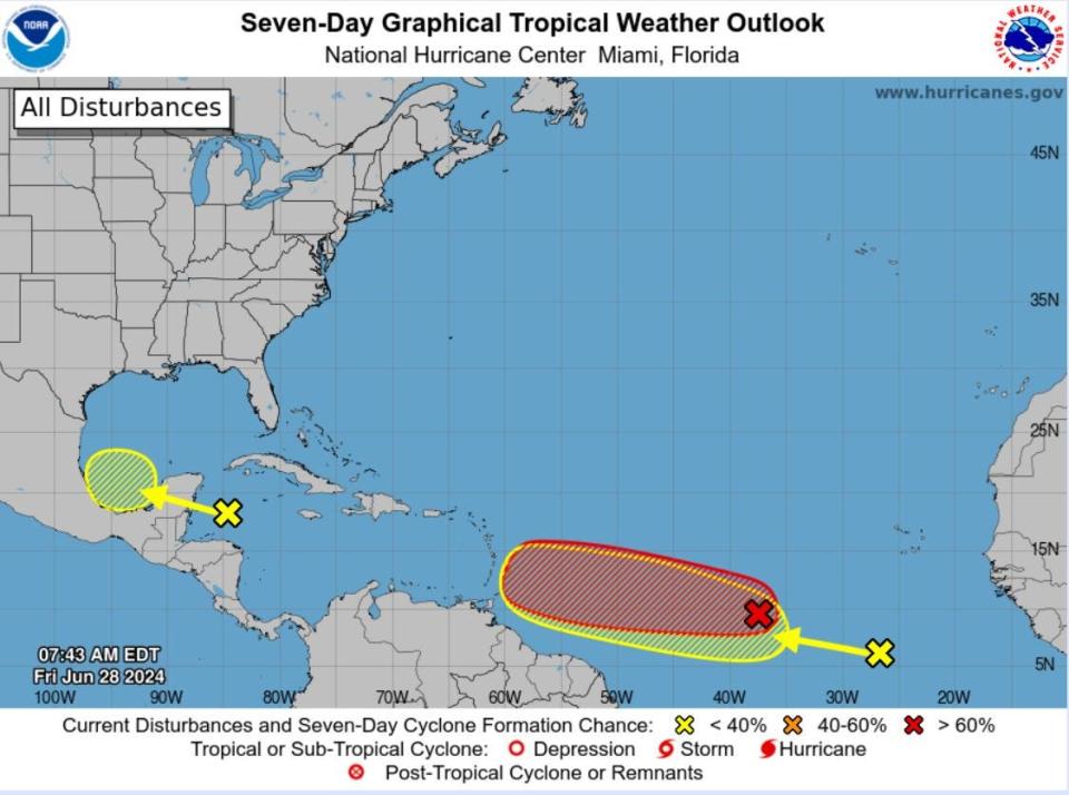
Following in Tropical Depression Two's footsteps is a tropical wave that the NHC said has a 20% chance of development over seven days.
The other disturbance is the lingering Invest 94L over the western Caribbean Sea, which has a 30% chance of formation over the next two days.
On average, the second named storm of a season doesn't typically form until July 17, with the third trailing on Aug. 3.
Normally, Saharan dust is too thick this time of year for much to get going in the tropical Atlantic between the Caribbean and Africa, but Tropical Depression Two and its companion are at such low latitudes they are avoiding the bulk of the dust.
Storm experts are debating the potential strength of the depression as it moves closer to the eastern Caribbean islands. The majority of intensity models have it becoming at least a Category 1 or Category 2 hurricane, but it is difficult to gauge strength or track before a system develops.
"It's not out of the question that the system could become a hurricane by the time it gets to the islands," Norcross said. "For now, high pressure over the southeastern U.S. appears most likely to hold the likely-Beryl well to the south, at least well into the Caribbean. But it's too early to be sure of the long term."
In the short term, if a heat advisory is issued for Palm Beach County it means the NWS expects the heat index temperatures to reach 108 or higher for at least two hours. An excessive heat warning is issued when the heat index is forecast to reach 113 or higher for at least two hours.
More: Man's death in South Florida heat prompts federal investigation into company that employed him
Why is it so hot?
The normal high temperature for West Palm Beach in late June is 89 degrees with an overnight low of 76 degrees.
An area of high pressure is parked near Florida, which generally means clear skies and fewer clouds. Light afternoon sea breezes will help build showers and thunderstorms through the weekend to help cool temperatures but they may be moving slowly. That could lead to localized flooding, NWS meteorologists said.
The heat advisory thresholds have changed
The NWS announced last week that Broward County would join Miami-Dade County in an experimental program that starts advisories at a lower threshold level. In those two counties, an advisor is issued if heat index temperatures of 195 or higher are expected for at least two hours. An excessive heat warning is issued if the heat index is expected to reach 110 or higher for at least two hours.
More: Climate change triggers new Florida heat warning chart that alerts when it could be deadly outside
Robert Molleda, meteorologist in charge at the NWS Miami office, said the changes were made at the request of the counties and align better with "local climatology" as well as recent health data that shows people get sick from temperatures lower than the current thresholds.
He said Palm Beach County may be included in the lower thresholds if it requests it and after an assessment this summer of how the alerts are issued in Broward and Miami-Dade.
"The bottom line in all of this is every part of our forecast area will still get alerted at the appropriate times," Molleda said last week. "The changes aren't permanent yet. We want to see how it's applied, and last year was a good start to evaluate it."
What is the heat index?
The heat index temperature is calculated through an equation that considers ambient temperature and the amount of moisture in the air, using the dew point or relative humidity.
Dew point is the amount of water vapor in the air. Relative humidity is a percentage describing the amount of saturation of air.
A higher dew point makes the body's natural cooling mechanism — sweat — less efficient.
What is a heat advisory?
A heat advisory means people sensitive to warm temperatures should take precautions to avoid heat illness, including staying hydrated and seeking breaks if working or playing outside. Signs of heat exhaustion or heat stroke include symptoms such as muscle cramps, excessive sweating, throbbing headache, passing out, confusion and seizures.
An excessive heat warning, the highest alert level on a four-tier scale, means everyone needs to take precautions to stay safe in the heat because "you may become seriously ill or even die," the NWS says.
Tips to beat the heat
Tips for keeping safe during excessively hot weather from the American Red Cross:
∎ If you suspect heat injury, call for help.
∎ Children and the elderly are among the most vulnerable.
∎ Try not to work outside in the hottest part of the day; if you must work in the heat, slow down.
∎ When outdoors, take frequent breaks in the shade.
∎ Drink plenty of water.
∎ If you wait until you feel thirsty, you're already getting dehydrated.
∎ Don't drink beverages containing caffeine or alcohol (sodas or beer). They interfere with the body’s temperature-regulating mechanisms.
∎ Sweating is the body’s mechanism for cooling. If you stop sweating, call for help.
Sunscreen advice
∎ Wear sunscreen every day, even if you're only going from house to car and car to office.
∎ Look for broad-spectrum UVA and UVB protection. The key ingredients? Titanium dioxide, zinc oxide or Parsol 1789. And never dip below SPF 15.
∎ Protect the oft-neglected eyelids, earlobes and lips. Women develop fewer skin cancers on their lips than men do because they enjoy the physical protection of lipstick.
∎ Cover up your kids. Children especially need sunblock — two-thirds of sun damage happens before the age of 15. But don't put sunscreen on babies under 6 months of age; keep them out of direct sunlight.
∎ Replace your sunscreen annually. Unopened, sunscreen has a shelf life of up to three years. Once opened, the SPF starts breaking down. It's a good idea to buy new products at the beginning of each summer.
∎ Complete all outdoor activities before 10 a.m. or start them after 4 p.m. to avoid the sun at its strongest.
∎ Get to know your skin. Practice self-exams to familiarize yourself with your own landscape. That way, you can more easily notice mole changes such as growing, bleeding or crusting. Have a skin cancer-related checkup, including a complete skin examination as recommended by the American Cancer Society every three years for people between 20 and 40 years of age, and every year for anyone 40 and older.
Kimberly Miller is a journalist for The Palm Beach Post, part of the USA Today Network of Florida. She covers real estate and how growth affects South Florida's environment. Subscribe to The Dirt for a weekly real estate roundup. If you have news tips, please send them to kmiller@pbpost.com. Help support our local journalism: Subscribe today.
This article originally appeared on Palm Beach Post: Heat advisory South Florida with heat index temperatures soaring

