Heat, rain return as tropical wave makes its way through Florida. See what to expect and when
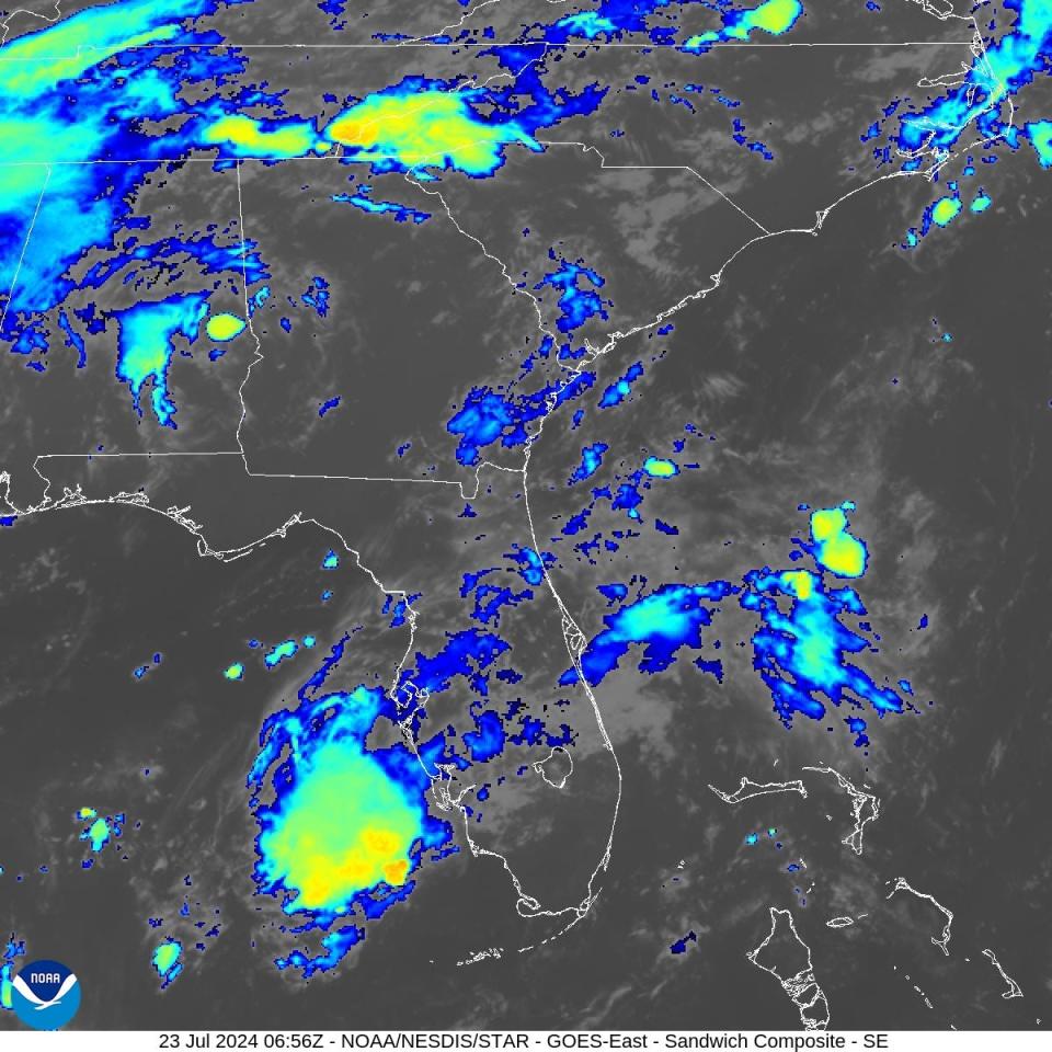
A tropical wave is expected to bring locally heavy showers and storms to portions of Florida through today.
Combined with lingering Saharan dust, some "dirty rain" is possible. The tropical moisture increasing Florida's rain chances won’t be anything organized, according to Ryan Truchelut, chief meteorologist at WeatherTiger.
While the tropics continue to remain quiet, activity is expected to pick up toward the end of July and the beginning of August.
The peak of hurricane season runs from mid-August through mid-October. If your hurricane supplies are running low, or you haven't started an emergency kit, Florida's next sales tax holiday the end of August can help you save money.
Elsewhere, the National Hurricane Center is monitoring two tropical waves.
Rain chances continue across much of Florida
A tropical wave of low pressure is increasing the chance for showers for Florida through today.
"This 'wave' is not expected to develop tropically, largely thanks to dust and drier air in the upper atmosphere that will put a lid on the strengthening of this wave and others elsewhere in the tropical Atlantic this week," according to AccuWeather.
Some areas could see locally heavy showers and storms.
The tropical wave is not forecast to develop into a tropical depression or a named tropical storm.
Temperatures and forecast expected today:
Pensacola: High 88. Heat indices ranging from 100-105 degrees. High rain chances in the afternoon and evening.
Tallahassee: High 95. Showers and thunderstorms look to develop much later in the day, allowing temperatures to soar. Heat index values approaching 108 may be possible.
Jacksonville: High 94. Lingering dry air moving in from the southeast may hinder some shower and storm development. Heat index values expected to range from the 100 to 107.
Daytona Beach: High 89. Scattered to numerous showers and storms are forecast across the area this afternoon and evening, especially over the interior.
Melbourne: High 90. Some stronger storms will be possible and capable of producing frequent lightning strikes, gusty winds to around 40 mph, and locally heavy rainfall of 1 to 3 inches. Peak heat index values of 103 to 107 this afternoon.
Port St. Lucie: High 91. Heat index values as high as 103. Main threats with any storms today will be lightning strikes, gusty winds, and locally heavy rainfall of 1 to 3 inches.
West Palm Beach: High 86. Another day of scattered to numerous thunderstorms is expected today. The strongest storms could produce gusty winds, frequent lightning, and heavy downpours.
Naples: High 91. Heat index values as high as 106. Showers and possibly a thunderstorm in the afternoon.
Fort Myers: High 91. Heat index values as high as 102. Showers and storms developing along the I75 corridor in the afternoon, then becoming more widespread in the late afternoon.
Sarasota: High 90. Heat index values as high as 110. Scattered showers and thunderstorms, then showers likely and possibly a thunderstorm late in the afternoon. Hazards to be aware of will be frequent lightning in storms, strong gusty winds, and heavy downpours.
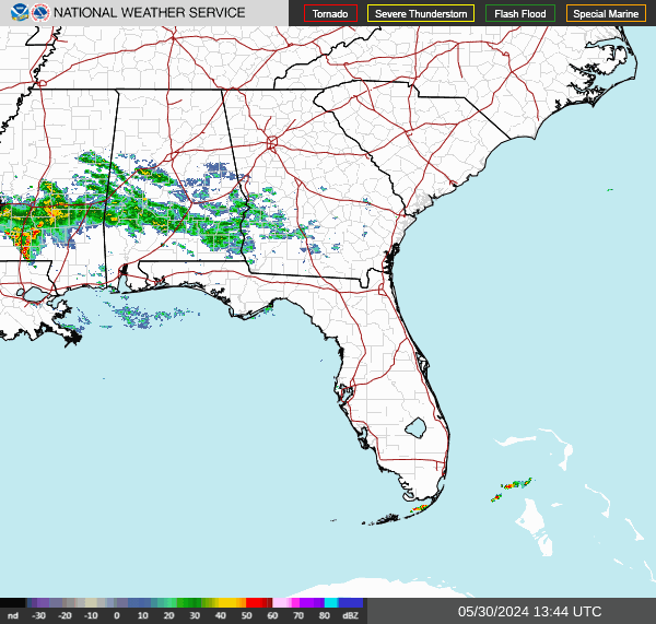
Florida weather radar: Track storms as they move across state
National Hurricane Center launching new cone of concern in August
Use the slider on the right to compare the prior cone to what it will look like beginning August 2024.
The National Hurricane Center's new experimental tropical cyclone forecast cone graphic will be coming out in mid-August, just in time for the peak period of hurricane season.
The new cone will add tropical storm and hurricane watches and warnings for interior counties in the path of the storm. The current cone displays watches and warnings only for coastal counties.
Watches and warnings for interior counties have been provided by local National Weather Service offices. The new graphic will combine tropical storm and hurricane watches and warnings into a single graphic.
The next storm of the season will be Debby.
What is NOAA tracking in Atlantic basin?
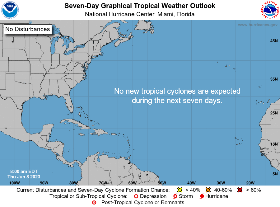
The National Hurricane Center said no tropical cyclone activity is expected over the next several days.
The National Hurricane Center is monitoring two tropical waves. Here's the latest update from the NHC as of 8 a.m. July 23:
Tropical wave 1: A tropical wave in the central Atlantic contains scattered showers. It's moving west at 11 mph.
Tropical wave 2: A tropical wave in the western Caribbean extends from the northwestern Caribbean into central Honduras.
Who is likely to be impacted?
A tropical wave is expected to bring tropical moisture to Florida through today.
Forecasters urge all residents to continue monitoring the tropics and to always be prepared. That advice is particularly important for what is expected to be a very active hurricane season.
When is next Florida hurricane tax-free supplies holiday?
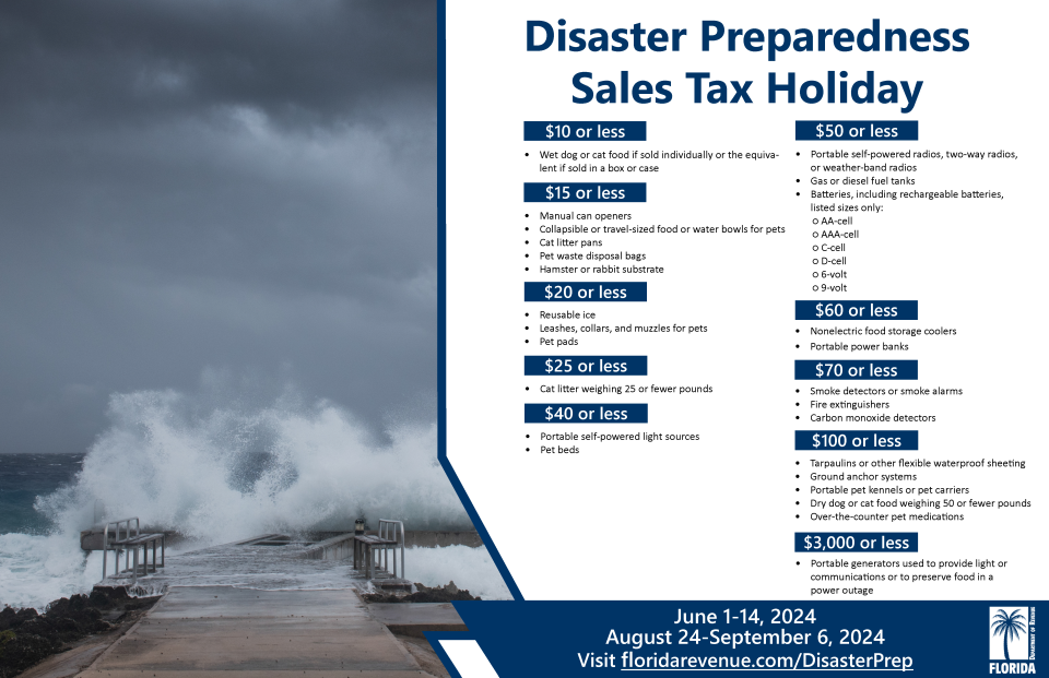
Save on hurricane supplies between Aug. 24 and Sept. 6. This will be the final tax-free holiday for 2024 when it comes to emergency supplies and it comes during the busiest period of the hurricane season.
Can't afford a generator or weeks of food? Here are the basics you should have on hand.
Eligible items included in the tax-free holiday include:
A portable generator used to provide light or communications or preserve food in the event of a power outage with a sales price of $3,000 or less.
A tarp or other flexible waterproof sheeting with a sales price of $100 or less.
An item normally sold as, or generally advertised as, a ground anchor system or tie-down kit with a sales price of $100 or less.
A smoke detector or smoke alarm with a sales price of $70 or less.
A fire extinguisher with a sales price of $70 or less.
A carbon monoxide detector with a sales price of $70 or less.
A nonelectric food storage cooler with a sales price of $60 or less.
A portable power bank with a sales price of $60 or less.
A gas or diesel fuel tank with a sales price of $50 or less.
A portable self-powered radio, two-way radio, or weather-band radio with a sales price of $50 or less.
A package of AA-cell, AAA-cell, C-cell, D-cell, 6-volt, or 9-volt batteries, excluding automobile and boat batteries, with a sales price of $50 or less.
A portable self-powered light source (powered by battery, solar, hand-crank, or gas) with a sales price of $40 or less, including: flashlights, lanterns and candles.
Eligible light sources and radios qualify for the exemption, even if electrical cords are included in the purchase.
Reusable ice (ice packs) with a sales price of $20 or less.
➤ See full list of items, including pet and cleaning supplies, exempt from sales tax
When is the Atlantic hurricane season?
The Atlantic hurricane season runs from June 1 through Nov. 30.
When is the peak of hurricane season?
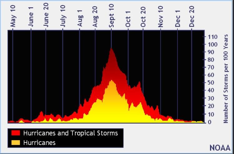
The peak of the season is Sept. 10, with the most activity happening between mid-August and mid-October, according to the Hurricane Center.
National Hurricane Center map: What are forecasters watching now?
Systems currently being monitored by the National Hurricane Center include:
Interactive map: Hurricanes, tropical storms that have passed near your city
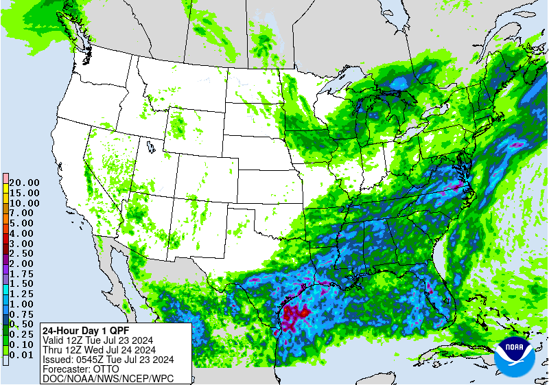
Excessive rainfall forecast
What's next?
We will continue to update our tropical weather coverage daily. Download your local site's app to ensure you're always connected to the news. And look for our special subscription offers here.
This article originally appeared on Treasure Coast Newspapers: Tropical wave bringing rain Florida. NHC tracking 2 systems

