Heavy rain, slight risk of flooding in Sioux Falls forecast through Wednesday morning
The possibility of severe weather in Sioux Falls will continue through Wednesday, with heavy rainfall and the potential of flooding the main risks, according to the National Weather Service.
The first round of storms is possible starting at about 6 p.m. Monday into early Tuesday morning, with slight risks of hail, winds up to 60 miles per hour and flooding, with rainfall amounts of up to a quarter of an inch.
A second round is possible beginning Tuesday afternoon through the evening, again with slight risks of hail, high winds and flooding.
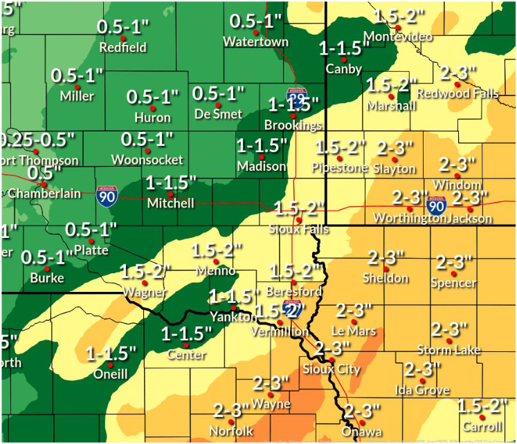
All told, as much as 2 inches of rain could fall by Wednesday afternoon in Sioux Falls, including totals from storms that moved through the area Monday morning.
The NWS states there is also a slight risk of flooding in the area through Wednesday morning, depending on rainfall totals, with soil saturation leading to the potential for ponding of water and rises in rivers and creeks.
Here's the forecast for the rest of the week:
Monday afternoon: A 40% chance of showers and thunderstorms. Cloudy, with a high near 75. East southeast wind around 15 mph, with gusts as high as 20 mph.
Monday night: A 30% chance of showers and thunderstorms, mainly before 10 p.m. Cloudy, then gradually becoming partly cloudy, with a low around 71. Breezy, with an east southeast wind 15 to 20 mph becoming south after midnight. Winds could gust as high as 30 mph.
Tuesday: A 50% chance of showers and thunderstorms, mainly after 11 a.m. Partly sunny, with a high near 82. Breezy, with a south southeast wind 10 to 20 mph becoming west in the afternoon. Winds could gust as high as 35 mph.
Tuesday night: A 40% chance of showers and thunderstorms, mainly after 1 a.m. Mostly cloudy, with a low around 57. West northwest wind 5 to 10 mph.
Juneteenth: A chance of showers and thunderstorms. Mostly cloudy, with a high near 70. Northeast wind around 10 mph. Chance of precipitation is 30%.
Wednesday night: A chance of showers and thunderstorms, then showers likely and possibly a thunderstorm after 1 a.m. Mostly cloudy, with a low around 60. East northeast wind 5 to 10 mph. Chance of precipitation is 60%.
Thursday: A 50% chance of showers and thunderstorms. Mostly cloudy, with a high near 76.
Thursday night: A 50% chance of showers and thunderstorms. Mostly cloudy, with a low around 66.
Friday: A 40% chance of showers and thunderstorms. Mostly sunny, with a high near 85.
Friday Night: A chance of showers and thunderstorms, then showers likely and possibly a thunderstorm after 1 a.m. Mostly cloudy, with a low around 69. Chance of precipitation is 70%.
Saturday: A 50% of showers and thunderstorms. Partly sunny, with a high near 79.
Saturday night: A 40% chance of showers. Partly cloudy, with a low around 61.
Sunday: Sunny, with a high near 80.
This article originally appeared on Sioux Falls Argus Leader: Rainy start to the week means flood risk for Sioux Falls, NWS says

