Heavy rains forecast for some areas of Florida as tropical wave approaches. See what to expect
While the tropics continue to stay quiet, you'll need to keep an umbrella handy this week.
The good news is that temperatures are expected to drop slightly, although heat advisories were issued for portions of Northeast Florida.
Flood advisories are in effect for a few areas in South Florida Monday afternoon.
The National Hurricane Center is monitoring two tropical waves, including one in the western Caribbean.
Tropical moisture may increase Florida's rain chances starting Monday, but, according to Ryan Truchelut, chief meteorologist at WeatherTiger, it won’t be anything organized. Saharan dust, high wind shear and other factors are expected to help keep the tropics quiet for the days ahead.
The peak of hurricane season runs from mid-August through mid-October. If your hurricane supplies are running low, or you haven't started an emergency kit, Florida's next sales tax holiday the end of August can help you save money.
Rain chances increase. Heat advisory issued for Northeast Florida
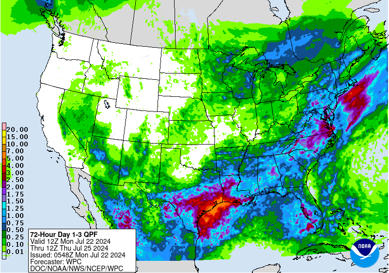
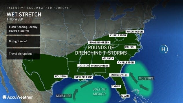
At least 2 to 4 inches of rain will fall over much of the Southeast states through the end of this week, according to AccuWeather. The rain is associated with air from the Gulf of Mexico and southwestern Atlantic moving over the Southeast.
Florida may be spared from some of the worst rains, but a tropical wave of low pressure is increasing the chance for showers through Tuesday.
"As the tropical wave approaches and moves northwestward across the state from Sunday to Tuesday, an uptick in the showers and thunderstorms will occur with the potential for some to bring flooding downpours, strong wind gusts and even waterspouts near the beaches," said Alex DaSilva, AccuWeather lead hurricane expert.
The tropical wave is not forecast to develop into a tropical depression or a named tropical storm.
Temperatures expected today:
Pensacola: High 87. Storms will start off along the coast and offshore during the early morning hours with better storm coverage spreading inland through the afternoon. Showers and storms will be scattered to locally numerous across much of the area by Monday afternoon. Localized minor flooding will be possible,
Tallahassee: High 93. Another day of widespread showers and thunderstorms across the region. Storms will likely get another early start.
Jacksonville: High 85. Chances for showers and storms increase this afternoon and into the evening hours. Periods of heavy rainfall will be possible. Not everyone will get the rain. A heat advisory has been issued until 6 p.m. for parts of North and Northeast Florida. Heat index values up to 108 to 110 expected.
Daytona Beach: High 89. Increased chances of showers and storms through Tuesday. A few storms may be strong, especially from Orlando north. Wind gusts up to around 50 mph are possible, along with locally heavy rainfall up to 1-3 inches.
Melbourne: High 90. Band of dry air near Melbourne before sunrise forecast to move north. Disturbance will help to generate scattered to numerous showers and storms today. Lingering showers and storms will be possible through sunset, generally west of Orlando. Drier conditions will then prevail overnight.
Port St. Lucie: High 90. Expect scattered to numerous showers and storms today. Overnight, a few showers and storms will remain possible along the Treasure Coast toward morning.
West Palm Beach: High 85. A tropical wave will approach South Florida early this morning. Just over 2 inches of rain expected by this afternoon. Showers and storms could impact the East Coast metro areas beginning early this morning continuing through the late morning hours.
Naples: High 90. Scattered to numerous thunderstorms will be possible this morning and afternoon. The strongest storms could produce gusty winds, frequent lightning, and heavy downpours. Localized flooding may become a concern today for areas that receive repeated rounds of heavy rainfall. A few waterspouts cannot be ruled out today across the local waters.
Fort Myers: High 91. Another typical Florida summer day in store, characterized by hot and humid conditions ending with showers and thunderstorms. Main concerns would be frequent lightning, localized heavy rainfall, and gusty winds. Storms will likely develop late afternoon over South Florida and move northwest through the evening.
Sarasota: High 92. A clash between Saharan dust in mid levels of the atmosphere with moisture in the lower levels could bring some stronger storms to the area today. Lightning, localized heavy rainfall, and gusty winds are all possible. The dust is expected to dissipate Monday into Tues.day. Scattered to numerous showers/storms are expected each day this week.
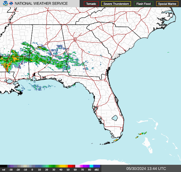
Florida weather radar: Track storms as they move across state
Dirty rain in Florida. Saharan dust helping keep tropics quiet
The Saharan dust and winds are keeping the tropics quiet now, but forecasters say that will likely change.
The dust will have another impact as the rain arrives.
"Because a significant amount of dust from the Sahara Desert is nearby, rain through this week may appear muddy and leave a residue on exposed surfaces in southern and central Florida," AccuWeather said.
"The favorable conditions that yielded Beryl are likely to return at some point in August, and that will probably yield an extended burst of hurricane activity," said Dr. Ryan Truchelut, chief meteorologist at WeatherTiger.
"WeatherTiger’s real-time forecast remains for around twice the amount of storm activity in a normal hurricane season."
The next storm of the season will be Debby.
What is NOAA tracking in Atlantic basin?
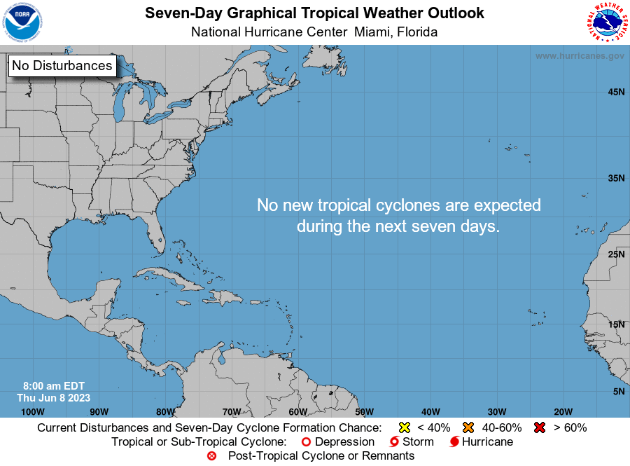
The National Hurricane Center said no tropical cyclone activity is expected over the next several days.
The National Hurricane Center is monitoring two tropical waves. Here's the latest update from the NHC as of 2 p.m. July 22:
Tropical wave 1: A tropical wave in the Atlantic is moving west at 11 to 17 mph.
Tropical wave 2: A tropical wave in the western Caribbean stretches from the Cayman Islands south across western Panama. It's moving west at 6 to 11 mph.
Who is likely to be impacted?
A tropical wave is expected to bring tropical moisture to Florida through Tuesday.
Forecasters urge all residents to continue monitoring the tropics and to always be prepared. That advice is particularly important for what is expected to be a very active hurricane season.
When is next Florida hurricane tax-free supplies holiday?

Save on hurricane supplies between Aug. 24 and Sept. 6. This will be the final tax-free holiday for 2024 when it comes to emergency supplies and it comes during the busiest period of the hurricane season.
Can't afford a generator or weeks of food? Here are the basics you should have on hand.
Eligible items included in the tax-free holiday include:
A portable generator used to provide light or communications or preserve food in the event of a power outage with a sales price of $3,000 or less.
A tarp or other flexible waterproof sheeting with a sales price of $100 or less.
An item normally sold as, or generally advertised as, a ground anchor system or tie-down kit with a sales price of $100 or less.
A smoke detector or smoke alarm with a sales price of $70 or less.
A fire extinguisher with a sales price of $70 or less.
A carbon monoxide detector with a sales price of $70 or less.
A nonelectric food storage cooler with a sales price of $60 or less.
A portable power bank with a sales price of $60 or less.
A gas or diesel fuel tank with a sales price of $50 or less.
A portable self-powered radio, two-way radio, or weather-band radio with a sales price of $50 or less.
A package of AA-cell, AAA-cell, C-cell, D-cell, 6-volt, or 9-volt batteries, excluding automobile and boat batteries, with a sales price of $50 or less.
A portable self-powered light source (powered by battery, solar, hand-crank, or gas) with a sales price of $40 or less, including: flashlights, lanterns and candles.
Eligible light sources and radios qualify for the exemption, even if electrical cords are included in the purchase.
Reusable ice (ice packs) with a sales price of $20 or less.
➤ See full list of items, including pet and cleaning supplies, exempt from sales tax
When is the Atlantic hurricane season?
The Atlantic hurricane season runs from June 1 through Nov. 30.
When is the peak of hurricane season?
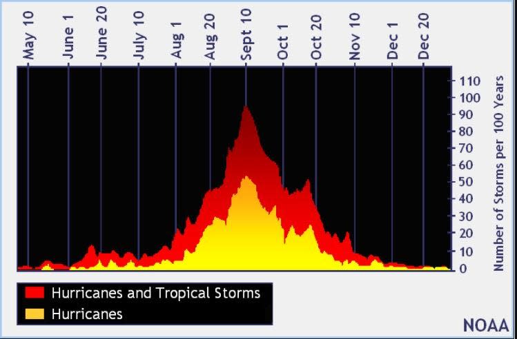
The peak of the season is Sept. 10, with the most activity happening between mid-August and mid-October, according to the Hurricane Center.
National Hurricane Center map: What are forecasters watching now?
Systems currently being monitored by the National Hurricane Center include:
Interactive map: Hurricanes, tropical storms that have passed near your city
Excessive rainfall forecast
What's next?
We will continue to update our tropical weather coverage daily. Download your local site's app to ensure you're always connected to the news. And look for our special subscription offers here.
This article originally appeared on Treasure Coast Newspapers: Florida tropical wave, dirty rain: Expected impact, radar, forecast

