Hurricane Beryl becomes Category 4 storm with 155-mph winds. See latest forecast path
Hurricane Beryl exploded Monday night, growing into a Category 5 hurricane with 165-mph winds, according to the National Hurricane Center.
Although it's still moving fast across the Caribbean, winds continue to weaken have have dropped to 155 mph, making it a strong Category 4 storm, according to the latest advisory from the National Hurricane Center.
When it made landfall at 11 a.m. on Carriacou Island Monday, July 1, it was a Category 4 storm with 150-mph winds.
At 5 p.m. Tuesday, the eye of Beryl was moving quickly west-northwestward to the south of Hispanola.
The next significant landmass in Beryl's path will be Jamaica on Wednesday," AccuWeather Lead Tropical Meteorologist Alex DaSilva said. "Jamaica is likely to experience a high risk to lives and property Wednesday."
NHC forecasters agree, saying Beryl is expected to bring "life-threatening winds and storm surge to Jamaica" on Wednesday and the Cayman Islands Wednesday night and Thursday.
Factors affecting Beryl's intensity include much warmer-than-historical-average waters and wind shear, according to AccuWeather forecasters. If wind shear is strong enough, it can lead to weakening of tropical systems. Warm water helps storms develop and intensify.
DaSilva said water temperatures in early July are equal to what they usually are in late August, early September.
"Even if Beryl loses some wind intensity during the second half of the week, it will remain a dangerous hurricane with the likelihood of torrential rain, flooding, mudslides, damaging winds, pounding seas and storm surge along and near its path," according to AccuWeather.
Hurricane Beryl set record as earliest Category 5 storm on record
#HurricaneBeryl is now a Category 5 hurricane on the Saffir-Simpson hurricane wind scale per the NHC's 11 p.m. advisory.
This is the earliest Category 5 hurricane on record, beating Emily's record from 2005 by 15 days. pic.twitter.com/ldLW2skgWP— WeatherTiger - weathertiger.substack.com (@wx_tiger) July 2, 2024
Beryl wasted no time in growing into a powerful hurricane.
The system making its way quickly across the Atlantic became a tropical depression Friday afternoon, a tropical storm by late Friday night and a hurricane about 24 hours later on Saturday.
By Sunday morning, Beryl had strengthened into a major Category 4 hurricane, with winds of 130 mph.
During landfall on Carriacou Island in Grenada at 11 a.m. Monday, it was a Category 4 storm with 150-mph winds.
Twelve hours later, it was a Category 5 storm with 160-mph winds.
Three hours later, at 2 a.m. Tuesday, it had strengthened again, with winds at 165 mph, which it was held on to until 11 a.m. when it started weaking slightly.
Its the earliest Category 5 storm on record, according to Dr. Ryan Truchelut, chief meteorologist at WeatherTiger. "This is the earliest Category 5 hurricane on record, beating Emily's record from 2005 by 15 days."
Truchelut works with the USA TODAY Network-Florida to provide the latest storm information Florida residents need.
Spaghetti models: Where will Hurricane Beryl go next?
Special note about spaghetti models: Illustrations include an array of forecast tools and models, and not all are created equal. The hurricane center uses only the top four or five highest performing models to help make its forecasts.
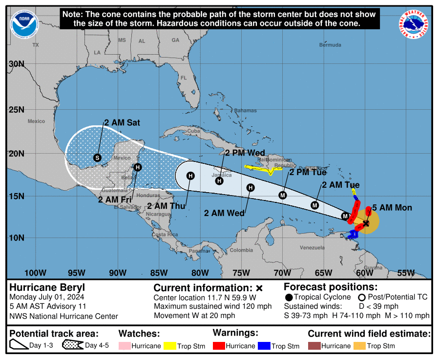
The National Hurricane Center said Beryl's center will move quickly across the central Caribbean Sea tonight and is forecast to pass near or over Jamaica on Wednesday. The center is expected to pass near or over the Cayman Islands Wednesday night or early Thursday and approach the Yucatan Peninsula of Mexico Thursday night.
"After that, there is a significant spread in the track guidance when Beryl emerges into the southwestern Gulf of Mexico, due mainly to model differences in the strength and location of a break in the subtropical ridge over the southern United States. Thus, there remains considerable uncertainty in the track forecast during the latter part of the forecast period."
The National Weather Service in Corpus Christi, Texas, advised residents "now is an excellent time to prepare for a potential tropical system: store documents in a waterproof container, stock up on water and non-perishable food items, and have a plan, just in case."
NWS forecasters also said the current forecast puts Beryl to the south of Texas but models vary widely beyond Thursday.
"We are still a bit early to determine any specific impacts for South Texas. An increased risk of rip currents, long period swell, and an elevated risk for minor coastal flooding will be possible along the Middle Texas Coast as early as this weekend.
"It is also possible that the outer bands of Beryl will reach South Texas Monday and Tuesday" but there is plenty of uncertainty.
Will Hurricane Beryl impact Florida, US?
After #Beryl impacts the Yucatan Thursday night and Friday, hopefully as a weaker hurricane, more and more guidance starts to turn it north once it reemerges over the Bay of Campeche on Saturday. Even though some guidance has Beryl a TS at this point, some keeps it as a… pic.twitter.com/wI5rXrlKqt
— Jim Cantore (@JimCantore) July 2, 2024
"After #Beryl impacts the Yucatan Thursday night and Friday, hopefully as a weaker hurricane, more and more guidance starts to turn it north once it reemerges over the Bay of Campeche on Saturday," Jim Cantore, The Weather Channel meteorologist tweeted Tuesday morning.
"Even though some guidance has Beryl a TS at this point, some keeps it as a hurricane so the western gulf needs to be on alert potentially for the later part of the holiday weekend and early next week. Much of the future fluctuation and strength will depend on shear and land interaction, but we still have lots of warm ocean out there to keep it going or strengthen it up at times. Stay tuned!"
AccuWeather meteorologists have given the Atlantic coast of the U.S. and the Florida Peninsula the all-clear from direct impacts from Beryl but warned residents to not let down their guard.
"At this point, the most likely scenario is for the storm to move westward into Mexico. However, it is very important to note that if the high pressure across the Southeast weakens, that can allow the storm to move farther north and potentially directly impact the Gulf Coast," DaSilva said.
"Should the high pressure area remain strong, Beryl will make landfall in Belize or Mexico's Yucatan Peninsula on Thursday night or Friday," said AccuWeather Chief On-Air Meteorologist Bernie Rayno.
"But if the high weakens just a bit, it may allow Beryl to take a more northwesterly track, in which case it may avoid more land and get into the Gulf of Mexico as a formidable hurricane instead of a chopped-down tropical storm that encounters more land."
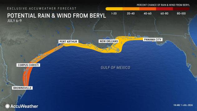
Because of the potential for Beryl to turn more to the northwest upon reaching the northwestern Caribbean, residents in the U.S., especially the Texas coast, should closely monitor the hurricane's progress and forecasts by meteorologists.
"From Panama City, to New Orleans, there is a low risk of direct impacts from Beryl, but from about Corpus Christi to Brownsville, Texas, the risk increases significantly due to the potential for Beryl to have more direct impacts," said AccuWeather Chief Meteorologist Jonathan Porter.
"That southern portion of the Texas coast is the zone we have to really watch."
Beryl and July 4: Could Hurricane Beryl affect your Florida Fourth of July plans?
Watches, warnings issued across Florida
Hurricane Beryl: What you need to know
Location: 125 miles southeast of Isla Beata, Dominican Republic; 420 miles east-southeast of Kingston, Jamaica
Maximum sustained winds: 155 mph
Movement: West-northwest at 22 mph
Pressure: 943 mb
Next advisory: 11 p.m.
Watches and warnings issued for Hurricane Beryl
For an explanation of what the watches and warnings mean, scroll to the bottom of this story.
Hurricane warning: A hurricane warning is in effect for:
Jamaica
Grand Cayman
Little Cayman and Cayman Brac
Hurricane watch: A hurricane watch is in effect for:
South coast of Haiti from the border with the Dominican Republic to Anse d'Hainault
Tropical Storm Warning: A tropical storm warning is in effect for the following:
South coast of Dominican Republic from Punta Palenque westward to the border with Haiti
South coast of Haiti from the border with the Dominican Republic to Anse d'Hainault
Hurricane Beryl 'powerful' Category 4 hurricane with 155-mph winds
At 5 p.m., the center of Hurricane Beryl was located near latitude 15.9 North, longitude 70.8 West.
Beryl is moving toward the west-northwest near 22 mph, and this general motion should continue through Wednesday, followed by a turn more toward the west on Thursday.
On the forecast track, the center of Beryl will move quickly across the central Caribbean Sea tonight and is forecast to pass near or over Jamaica on Wednesday. The center is expected to pass near or over the Cayman Islands Wednesday night or early Thursday and approach the Yucatan Peninsula of Mexico Thursday night.
Maximum sustained winds are near 155 mph, with higher gusts and Beryl remains a Category 4 hurricane on the Saffir-Simpson Hurricane Wind Scale.
Weakening is forecast during the next day or two. However, Beryl is forecast to be at or near major hurricane intensity while it passes near Jamaica on Wednesday and the Cayman Islands on Wednesday night.
Additional weakening is expected thereafter, though Beryl is forecast to remain a hurricane in the northwestern Caribbean.
Hurricane-force winds extend outward up to 40 miles from the center and tropical-storm-force winds extend outward up to 185 miles
How strong is Hurricane Beryl and where is it going?
Key messages from the National Hurricane Center: What you need to know about Hurricane Beryl
Devastating hurricane-force winds, life-threatening storm surge, and damaging waves are expected in portions of Jamaica and the Cayman Islands Wednesday and Wednesday night. Residents in these areas should listen to local government and emergency management officials for preparedness and/or evacuation orders.
Heavy rainfall and life-threatening flash flooding are likely over much of Jamaica and southern Hispaniola through late Wednesday.
Beryl is forecast to remain a hurricane when it approaches the Yucatan Peninsula and Belize late Thursday where additional watches will likely be required later today or tonight.
There remains uncertainty in the track and intensity forecast of Beryl over the western Gulf of Mexico this weekend. Interests in the southwestern and western Gulf of Mexico should monitor the progress of Beryl.
Current forecast: How strong is Hurricane Beryl expected to get?
Currently: 155 mph
12 hours: 145 mph
24 hours: 125 mph
36 hours: 110 mph
48 hours: 100 mph
60 hours: 85 mph
72 hours: 65 mph, inland
96 hours: 70 mph, over water
120 hours: 70 mph
What impact could Hurricane Beryl have and what areas could be affected?
WIND: Hurricane conditions are expected to reach the coast of Jamaica within the warning area on Wednesday. Winds are expected to first reach tropical storm strength early on Wednesday, making outside preparations difficult or dangerous. Hurricane conditions are expected to reach the Cayman Islands Wednesday night or early Thursday. Winds are expected to first reach tropical storm strength on Wednesday, making outside preparations difficult or dangerous. Tropical storm conditions are expected in the warning area along the south coast of Hispaniola this afternoon and tonight.
STORM SURGE: Storm surge could raise water levels by as much as 5 to 8 feet above normal tide levels in areas of onshore winds along the immediate coast of Jamaica. Storm surge could raise water levels by as much as 2 to 4 feet above normal tide levels in areas of onshore winds along the immediate coast of the Cayman Islands. Storm surge could raise water levels by as much as 1 to 3 feet above ground level in areas of onshore winds along the southern coast of Hispaniola.
RAINFALL: Hurricane Beryl is expected to produce rainfall totals of 4 to 8 inches, with localized maxima of 12 inches, across Jamaica and southwestern Haitian Peninsula through late Wednesday. Beryl will also produce rainfall amounts of 4 to 8 inches with isolated amounts of 10 inches across Barahona Peninsula in southwest Dominican Republic. Isolated totals of 6 inches or more are also anticipated across the mountainous terrain in the central Dominican Republic. This rainfall is likely to cause flash flooding and mudslides. Beryl is also expected to produce rainfall totals of 2 to 4 inches with localized maxima of 6 inches over the Cayman Islands Wednesday into Thursday.
SURF: Large swells generated by Beryl will continue across the Windward and southern Leeward Islands during the next day or so. Swells will impact the southern coasts of Puerto Rico and Hispaniola, and begin affecting Jamaica and the Cayman Islands through midweek. These swells are expected to cause life-threatening surf and rip current conditions. Please consult products from your local weather office.
Interactive map: What tropical storms, hurricanes have impacted your area in the past?
What do the watches and warnings from NHC mean?
What is storm surge? Graphics explain the deadly weather event
Hurricane warning: A hurricane warning means that hurricane conditions are expected somewhere within the warning area. A warning is typically issued 36 hours before the anticipated first occurrence of tropical-storm-force winds, conditions that make outside preparations difficult or dangerous. Preparations to protect life and property should be rushed to completion.
Hurricane watch: A hurricane watch means that hurricane conditions are possible within the watch area. A watch is typically issued 48 hours before the anticipated first occurrence of tropical-storm-force winds, conditions that make outside preparations difficult or dangerous.
Tropical storm warning: A tropical storm warning means that tropical storm conditions are expected somewhere within the warning area within 36 hours.
Tropical storm watch: An announcement that sustained winds of 39 to 73 mph are possible within the specified area within 48 hours in association with a tropical, subtropical, or post-tropical cyclone.
Storm surge warning: A storm surge warning means there is a danger of life-threatening inundation, from rising water moving inland from the coastline, in the indicated locations. This is a life-threatening situation. Persons located within these areas should take all necessary actions to protect life and property from rising water and the potential for other dangerous conditions. Follow evacuation and other instructions from local officials.
Storm surge watch: A storm surge watch means there is a possibility of life-threatening inundation, from rising water moving inland from the coastline, in the indicated locations during the next 48 hours.
This article originally appeared on Treasure Coast Newspapers: Hurricane Beryl heads toward Jamaica, now as Category 4 storm

