Beryl downgraded to tropical storm after landfall. See path, impacts in Houston, Austin
The first hurricane of the 2024 Atlantic hurricane season was downgraded to a tropical storm after slamming into Houston Monday morning.
The now former Hurricane Beryl, the second named storm of the year, has been a long-lasting storm that made three landfalls over eight days, including one as a powerful Category 4 storm with 150-mph winds.
➤ Live updates: Get the latest on Hurricane Beryl after its Texas landfall
And it's not done quite yet.
Beryl made its third landfall at about 4:30 a.m. July 8 near Matagorda, Texas, as a Category 1 storm with 80-mph winds. It's expected to weaken over land but it's still forecast to be a tropical storm early Tuesday morning by the time it reaches the border with Louisiana.
The forecast calls for it to remain a tropical depression as it moves north during the week, affecting states from Arkansas to Ohio and Michigan, according to the National Hurricane Center.
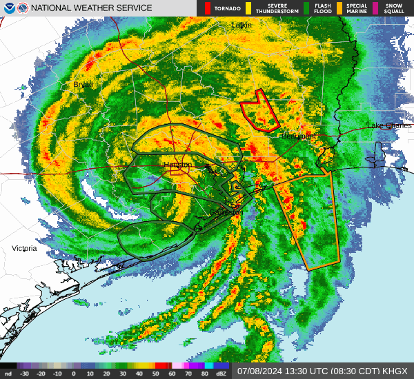
Impacts possible in Houston, Texas from Beryl
After making landfall near Matagorda, Hurricane Beryl's motion has been northerly, with small, brief wobbles. This general motion is expected to continue today as it crosses Southeast Texas.
A tropical storm warning remains in effect for Houston, Kingwood and Spring.
Though the storm will weaken back to a tropical storm as it moves farther inland, it will continue to bring gusty winds, periods of heavy rain and potential for brief tornadoes to the Houston area, according to the National Weather Service, Houston.
Peak wings could reach 45 to 60 mph, with gusts up to 85 mph. Expect tropical storm-force winds to continue until late this afternoon.
The threat for all of these hazards is relatively higher for areas to the east of the storm`s center.
The current forecast track brings the center of the storm along the westernmost portions of the Houston metro later this morning and early this afternoon. By this evening, the center of the storm will be exiting the area and conditions will improve.
Potential threats across the area include wind, storm surge, flooding rain and tornadoes.
As of 9:20 a.m., no reported damages by the City of Corpus Christi.
What to expect as Beryl moves through Austin, Texas
Beryl is forecast to move north just east of U.S. Route 77 by the early afternoon, according to the National Weather Service Austin. Tropical storm conditions are possible in the coastal plains as the storm moves inland, pouring heavy rain along Route 77.
A tropical storm warning is in effect for Lavaca and Fayette counties. A flood watch is in effect for Lavaca, Fayette and Lee counties.
Much of the rain will occur through Monday morning with the highest rainfall in South-Central Texas, the NWS reported. Counties in the flood watch area could see up to four inches of rain.
As the storm moves north, Hill Country, Edwards Plateau and the Rio Grande Plains could see showers and thunderstorms Monday afternoon into the night. These regions can expect gusty winds, hail and heavy rains, the NWS reported.
Track Tropical Storm Beryl: See latest radar images as Beryl moves into Texas
Spaghetti models: Where will Tropical Storm Beryl go next?
Special note about spaghetti models: Illustrations include an array of forecast tools and models, and not all are created equal. The Hurricane Center uses only the top four or five highest performing models to help make its forecasts.
Track Beryl to see latest forecast path
See Beryl grow from tropical depression to Category 5 storm
Beryl timeline: From tropical depression to Category 5 storm
June 28, 5 p.m.: Tropical Depression 2 forms in Central Atlantic, about 1,225 miles east-southeast of Barbados. Winds at 35 mph.
June 28, 11 p.m.: Tropical Storm Beryl forms about 1,110 miles east-southeast of Barbados. Winds at 40 mph.
June 29, 5 p.m.: Beryl becomes first hurricane of 2024 season 720 miles east-southeast of Barbados. Winds at 75 mph.
June 30, 8 a.m.: Beryl becomes Category 3 hurricane 420 miles east-southeast of Barbados. Winds at 115 mph.
June 30, 11:35 a.m.: Beryl is now a Category 4 hurricane 350 miles east-southeast of Barbados. Winds at 130 mph.
July 1, 11:10 a.m.: Landfall No. 1. Beryl makes landfall as Category 4 hurricane at Carriacou Island, Grenada. Winds at 150 mph.
July 1, 11 p.m.: Beryl becomes Category 5 hurricane in eastern Caribbean. Winds at 160 mph.
July 2, 2 a.m.: Beryl strengthens even more in eastern Caribbean. Winds hit 165 mph.
July 2, 2 p.m.: Beryl weakens slightly as the eye passes south of the Dominican Republic. Winds at 155 mph.
July 3, 5 p.m.: Eyewall of Beryl brushes south coast of Jamaica. Winds at 140 mph.
July 4, 8 a.m.: Center of Beryl passes southwest of Grand Cayman Island. Winds at 120 mph.
July 4, 9:30 p.m.: Beryl strengthens back to Category 3 storm as it approaches Yucatan Peninsula. Winds at 115 mph.
July 5, 6:05 a.m.: Landfall No. 2: Beryl makes landfall on Yucatan Peninsula northeast of Tulum, Mexico as a Category 2 storm. Winds at 110 mph.
July 5, 1 p.m. CDT: Beryl weakens into tropical storm as it moves over Mexico. Winds at 70 mph.
July 5, 10 p.m. CDT: Beryl enters Gulf of Mexico as tropical storm. Winds at 60 mph.
July 7, 11 p.m. CDT: Beryl become a hurricane again 65 miles south-southeast of Matagorda, Texas. Winds at 75 mph.
July 8, 4 a.m. CDT: Landfall No. 3. Beryl makes landfall near Matagorda, Texas, as Category 1 storm. Winds at 80 mph.
July 8, 10:08 a.m. CDT: Beryl weakens into a tropical storm over Texas.
This article originally appeared on Austin American-Statesman: Tropical Storm Beryl makes landfall in Matagorda, Texas
