Was Hurricane Beryl an Ominous Sign of Things To Come This Fall?
East Coast and Caribbean surfers have a love/hate relationship with Hurricane Season. While the season runs between June 1 and November 30, August or September is historically when tropical activity kicks into high gear with the season's first major storm and swell.
Not this year.
On June 29, Tropical Storm Beryl rapidly intensified into a major Category 4 in less than 48 hours. It was the earliest Category 4 storm in recorded history in the Atlantic. Quickly after formation, Beryl set out on a westward path of destruction, smashing into Carriacou on June 31 (while also damaging nearby islands of St. Vincent and Grenada), before picking up category 5 strength in early July, brushing Jamaica, nailing the Yucatan, reforming in the Gulf of Mexico, and finally making a US landfall in Texas. That's 4 countries in 10 days, leaving at least 25 people dead and causing billions in damage.
All before August.
Related: Scientists Say Climate Change Is Making Hurricanes Stronger
According to this article from The Surfrider Foundation, "The destruction in these small island nations from Hurricane Beryl highlights the environmental justice concerns of climate-fueled tropical storms and hurricanes in the Caribbean and Latin America. Despite contributing less than 10% of global greenhouse gas emissions, this region is experiencing the brunt of climate change impacts, including stronger, more intense hurricanes at a disproportionate rate."
The article points out that the Galveston, Texas area was also hit especially hard despite Beryl's Cat 1 strength at impact, highlighting how important it is to take these storms seriously, even if they don't make landfall with extreme winds. "The life-threatening impacts of this storm and subsequent power outages have been further exacerbated by a dangerous heat wave, with heat indices in the triple digits throughout the region. Mere weeks before Beryl hit, Galveston and the Bolivar Peninsula experienced up to four feet of storm surge from Tropical Storm Alberto, which made landfall nearly 400 miles away, yet significantly eroded beaches and weakened the dune systems there, degrading the natural protective barriers between the Gulf and landward development, and shrinking the public beach area."
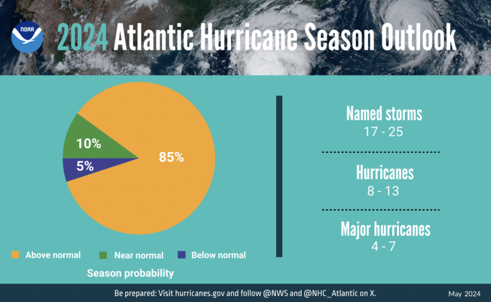
If Beryl was only an appetizer, we want nothing to do with the main course. Unfortunately, it doesn't appear that we'll have a choice. According to NOAA, there's an 85% chance of an above-normal season, with 17 to 25 total named storms, and 4 to 7 major hurricanes.
So why, exactly, are they forecasting a supercharged season? NOAA says it's "due to a confluence of factors, including near-record warm ocean temperatures in the Atlantic Ocean, development of La Nina conditions in the Pacific, reduced Atlantic trade winds and less wind shear, all of which tend to favor tropical storm formation." As if that's not enough, NOAA also notes that there's a "potential for an above-normal west African monsoon, which can produce African easterly waves that seed some of the strongest and longer-lived Atlantic storms."
In the 10 or so days since Beryl dissipated into the middle of America, things have been quiet in the tropics. But don't let that fool you. This is only the calm before the (next) storm. If you live in a hurricane-prone zone (i.e. the entire Atlantic) take this time to get prepared. Because if you fail to plan, you plan to fail, and that's no place to be when the next Beryl has your home in its crosshairs.
Related: 2024 Atlantic Hurricane Season Could Be Off The Charts

