Hurricane Beryl was one for the record books. Here's why and how it impacted so many
Hurricane Beryl was one for the record books.
Literally.
And repeatedly.
The storm that started in the Atlantic on June 28 grew to a monster Category 5 storm, made three landfalls, and killed at least 11 as it carved a path of destruction across the Caribbean and at least four in Texas after coming ashore as the season's first hurricane.
On Monday, July 8, just over 12 hours after making landfall in Texas as a Category 1 hurricane, Beryl was a tropical depression. While the National Hurricane Center issued it last advisory on the system early July 9, Beryl still isn't done making its presence felt.
It's expected to bring heavy rainfall and possibly flash flooding from the lower and mid Mississippi Valley to the Great Lakes Tuesday, July 9, and Wednesday, according to the final advisory from the National Hurricane Center. Storms could also bring a risk for tornadoes as Beryl moves north.
Here's how many records Beryl set over its life, as provided by Dr. Philip Klotzbach, meteorologist at Colorado State University specializing in Atlantic basin seasonal hurricane forecasts.
The Atlantic hurricane database goes back to 1851. More accurate data is available once the satellite era began in 1966.
Intensity: Hurricane Beryl had strongest sustained winds prior to August
165 mph: That's Category 5 hurricane strength and the strongest maximum sustained winds for an Atlantic hurricane prior to August on record. The old record was Emily in 2005, with 160-mph winds.
934 hPa: It's the third lowest central pressure for an Atlantic hurricane prior to August on record. Emily was 929 hPa and Dennis, also in 2005, was 930 hPa.
Earliest Category 4 and Category 5 hurricanes on record
Category 4, June 30: Beryl becomes the earliest Category 4 hurricane on record. Beating Dennis' record of July 8, 2005.
Category 5, July 2 UTC: Beryl becomes the earliest Category 5 hurricane on record, beating Emily's record of July 17, 2005.
Beryl becomes hurricane farthest east in Atlantic since 1933
49.3W: Beryl becomes a hurricane at 49.3 West, the farthest east an Atlantic hurricane had formed in the tropics — which is north of 23.5 North. If measured straight east from the southern tip of Florida, that's almost 2,000 miles in the Atlantic. The old record was the Cuba-Brownsville hurricane of 1933, which formed at 59.0 West.
Rapid intensification
Rapid intensification in a tropical storm or hurricane is defined as an increase of 35 mph in 24 hours or less.
65 mph over 24 hours: Between June 29 and June 30, Beryl's maximum sustained winds increased by 65 mph over 24 hours, the fastest intensification over a 24-hour period for any Atlantic named storm that early in a calendar year. The previous record of 65 mph over 24 hours was Bertha July 6-7 in 2008.
Most Accumulated Cyclone Energy days before Aug. 1 on record
Accumulated Cyclone Energy, often abbreviated as ACE, is the metric used by meteorologists to "measure the collective strength and duration" of tropical storms and hurricanes, according to NOAA.
35 days: Beryl racked up the most Accumulated Cyclone Energy days, 35, by a single Atlantic named storm prior to Aug. 1. The old record of 33 days was set by Emily in 2005.
Measuring Beryl in days
4.5 days: The number of days Beryl spent as a major hurricane, which is a storm with maximum sustained winds of at least 111 mph, or Category 3 or higher. Prior record was — you guessed it — Emily with 4.25 days as a major hurricane.
9.75 days: The number of named storm days for Beryl. This is the sixth most for a storm named prior to Aug. 1.
6.25 days: The number of days Beryl spent as a hurricane. That's the seventh most for a storm named prior to Aug. 1.
Beryl made three landfalls as a hurricane
Landfall No. 1: July 1, Carriacou Island, Grenada, Category 4 hurricane with winds of 150 mph.
Strongest hurricane on record to make landfall in Grenada. Hurricane Ivan in 2004 did not officially make landfall on Grenada but passed about 10 miles south of the main island of Grenada with maximum winds estimated at 125 mph, damaging 90% of the homes on the island.
Landfall No. 2: July 5, Tulum, in state of Quintana Roo, Mexico, Category 2 hurricane with winds of 110 mph.
Beryl became the first Category 2-plus hurricane to make landfall in Quintana Roo in July sinceEmily hit in 2005 as a Category 4 with 130-mph winds.
Landfall No. 3: July 8, Matagorda, Texas, Category 1 hurricane with winds of 80 mph.
Beryl was the earliest hurricane to made landfall in Texas since Bonnie on June 26, 1986.
Beryl was the 10th hurricane to make landfall in Texas in July on record and the first since Hanna in 2020.
Damage left behind after Hurricane Beryl landfall in Texas
Beryl damage after landfall near tourist destinations in Mexico
Damage left by Beryl in Carriacou, Grenada, compared to 'Armageddon'
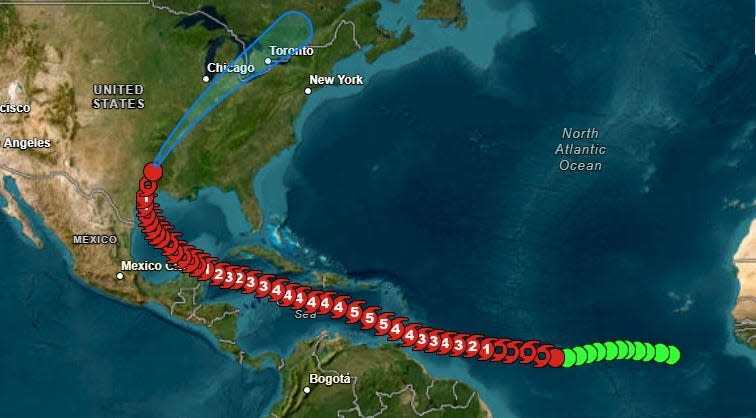
Beryl timeline: From tropical depression to Category 5 storm
June 28, 5 p.m.: Tropical Depression 2 forms in Central Atlantic, about 1,225 miles east-southeast of Barbados. Winds at 35 mph.
June 28, 11 p.m.: Tropical Storm Beryl forms about 1,110 miles east-southeast of Barbados. Winds at 40 mph.
June 29, 5 p.m.: Beryl becomes first hurricane of 2024 season 720 miles east-southeast of Barbados. Winds at 75 mph.
June 30, 8 a.m.: Beryl becomes Category 3 hurricane 420 miles east-southeast of Barbados. Winds at 115 mph.
June 30, 11:35 a.m.: Beryl now a Category 4 hurricane 350 miles east-southeast of Barbados. Winds at 130 mph.
July 1, 11:10 a.m.: Landfall No. 1. Beryl makes landfall as Category 4 hurricane at Carriacou Island, Grenada. Winds at 150 mph.
July 1, 11 p.m.: Beryl becomes Category 5 hurricane in eastern Caribbean. Winds at 160 mph.
July 2, 2 a.m.: Beryl strengthens even more in eastern Caribbean. Winds hit 165 mph.
July 2, 2 p.m.: Beryl weakens slightly as the eye passes south of the Dominican Republic. Winds at 155 mph.
July 3, 5 p.m.: Eyewall of Beryl brushes south coast of Jamaica. Winds at 140 mph.
July 4, 8 a.m.: Center of Beryl passes southwest of Grand Cayman Island. Winds at 120 mph.
July 4, 9:30 p.m.: Beryl strengthens back to Category 3 storm as it approaches Yucatan Peninsula. Winds at 115 mph.
July 5, 6:05 a.m.: Landfall No. 2: Beryl makes landfall on Yucatan Peninsula northeast of Tulum, Mexico as a Category 2 storm. Winds at 110 mph.
July 5, 1 p.m. CDT: Beryl weakens into tropical storm as it moves over Mexico. Winds at 70 mph.
July 5, 10 p.m. CDT: Beryl enters Gulf of Mexico as tropical storm. Winds at 60 mph.
July 7, 11 p.m. CDT: Beryl become a hurricane again 65 miles south-southeast of Matagorda, Texas. Winds at 75 mph.
July 8, 4 a.m.: CDT: Landfall No. 3. Beryl makes landfall near Matagorda, Texas, as Category 1 storm. Winds at 80 mph.
July 8, 11 a.m. CDT: Beryl weakens into tropical storm. Winds at 70 mph.
July 8, 7 p.m. CDT: Beryl becomes tropical depression. Winds at 35 mph.
July 9, 4 a.m. CDT: Beryl weakens further as it moves north. Winds at 30 mph. NHC issues final advisory.
This article originally appeared on Treasure Coast Newspapers: Hurricane Beryl: 3 landfalls, records, earliest Cat 5 storm ever

