Hurricane Beryl swells to a monster Category 5. It could weaken before it hits Jamaica
Hurricane Beryl broke a new slew of records overnight Monday by strengthening into a massive Category 5 hurricane — the earliest on record in July — and putting Jamaica more solidly in the crosshairs of a hit from a major storm on Wednesday.
All week, the National Hurricane Center has forecast a weakening late Tuesday and early Wednesday, when conditions in the Caribbean shift and less-friendly winds start to tear the storm down.
Hurricane Beryl, which has already left a wake of death and destruction in the southeastern Caribbean, appeared determined to run out the meteorological clock, strengthening until the last possible moment over hotter-than-usual waters.
But by mid-morning Tuesday, the storm’s maximum sustained winds had already started to decline, a welcome sign that Jamaica could see impacts from a slightly less intense windstorm, although the broad wind field and still-high winds still spell trouble. In addition, the newest track nudged the potential path of the eye even further north, meaning a direct landfall of a Category 4 storm in Jamaica.
Beryl could bring sustained winds of 140 mph, 5 to 8 feet of storm surge and up to a foot of rain in Jamaica, sparking a hurricane warning for the island and a flurry of disaster preparations and evacuation warnings.
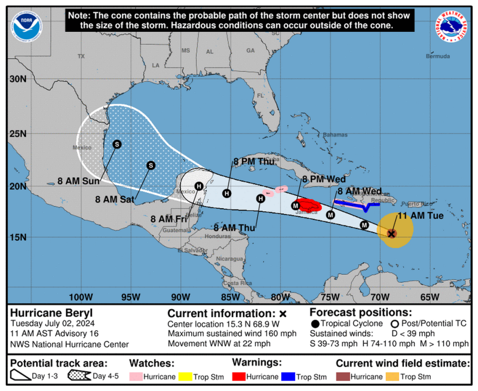
The latest forecast called for Beryl’s eye to pass across the southern coast of Jamaica as a Category 4 hurricane on Wednesday, then swipe south of the Cayman Islands as a Category 3 hurricane on Thursday before making landfall in Quintana Roo in the Yucatan Peninsula on Friday as a Category 1.
A large high-pressure ridge over Cuba, Haiti and the Dominican Republic is expected to do most of the work steering Beryl west, where forecasters predict it will bump into a patch of storm-toppling wind shear on Tuesday and Wednesday.
“The Bermuda High remains in control,” wrote Sammy Hadi, a meteorologist with the Miami office of the National Weather Service, on X, the social media site formerly known as Twitter.
Taking a look at the big picture view of Major Hurricane #Beryl this morning.
Beryl is nestled between 25-40 knots of southwesterly wind shear just to the west thanks to an T.U.T.T. over Colombia & a large plume of Saharan Dust to the east. The Bermuda High remains in control. pic.twitter.com/mxCOCh3pCN— Sammy Hadi (@SammyHadiWx) July 2, 2024
Beryl’s tangle with Jamaica and the Cayman Islands, combined with that unfavorable wind shear, could further weaken the storm.
Earlier forecasts appeared to show Beryl slowing down even further, or even stopping, over the Yucatan, but the latest tracks suggest the storm could emerge in the Gulf of Mexico as at least a tropical storm and potentially find a new target for landfall over the weekend.
READ MORE: ‘The situation is grim.’ Hurricane Beryl shreds Caribbean islands, kills at least 4
“The models show quite a wide range of solutions, with guidance between a strong tropical storm to a major hurricane while it nears the Yucatan Peninsula,” forecasters wrote. “This is quite an uncertain forecast beyond a couple of days.”
As of the 11 a.m. advisory, Beryl was packing sustained winds of 160 mph and headed west-northwest at 22 mph. Hurricane-force winds extended 40 miles from the clearly-defined eye, and tropical-storm-force winds extended out about 175 miles from the center.
Four deaths, lots of damage
In Beryl’s wake, residents of the eastern Caribbean islands slammed by the fast-moving and hard-hitting storm were assessing damages on Tuesday.
Particularly hard hit is St. Vincent and the Grenadines’ Union Island, where at least one death has been reported. Three other deaths also were reported, including two in Grenada.
Multiple reports suggest 90% of the houses and businesses on Union island have been destroyed. The islands of Carriacou and Petite Martinique, where Beryl’s eye made landfall on Monday, reported 95% of homes were uninhabitable.
“The situation is grim,” Grenada’s Prime Minister Dickon Mitchell said in a morning press conference. “There’s almost complete destruction of homes and buildings on the islands. The roads are not passable and in many instances cut off because of the large quantity of debris strewn all over the streets and obviously the danger posed by down power lines.”
With Beryl expecting to bring life-threatening winds and storm surges to Jamaica, the government has activated disaster preparedness and its response mechanisms in anticipation of the hurricane’s passage.
The eastern Caribbean also remains on guard against another potential tropical system, a disturbance that the hurricane center is tracking in the central Atlantic.
On Tuesday morning, the hurricane center continued its trend of lowering the system’s chances of formation anytime soon, this time to a 30% shot over the next week and 20% chance of strengthening into a tropical depression in the next two days.
“Environmental conditions are only marginally conducive for development of this system,” forecasters wrote. “Interests in the Lesser Antilles should still monitor the progress of this system, with heavy rainfall possible midweek.”

