Beryl on track to restrengthen in Gulf before Texas landfall

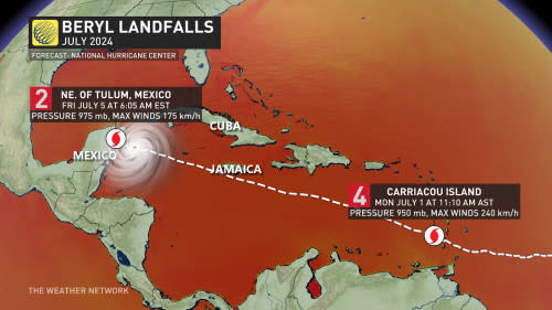
Beryl weakened to a tropical storm on Friday after making landfall south of Cancun, Mexico, during the early morning hours.
Days after slamming the Antilles as a high-end hurricane with destructive winds, Beryl is lashing Mexico's Yucatan Peninsula with high winds, flooding rains, and dangerous coastal flooding.
The storm will then enter the Gulf of Mexico for its final charge toward the Texas coast early next week. Forecasters will then closely watch the remnants of the storm.
DON’T MISS: Canadian Red Cross launches appeal to help people impacted by Hurricane Beryl
Beryl made landfall as a Category 2 hurricane early Friday morning before weakening down to a tropical storm over land through the day.
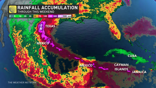
Communities in the path of the storm can expect damaging winds, flooding rains of 100+ mm in spots, as well as life-threatening storm surge flooding along the coast.
Check out The Weather Network’s hurricane hub for all the latest on the active hurricane season ahead
Beryl will emerge in the southern Gulf of Mexico on Friday night as it turns slightly more toward the northwest.
Very warm waters in the Gulf may allow the system to regain some strength and organization heading into the weekend as it makes its final track toward the Texas coast by the beginning of next week.
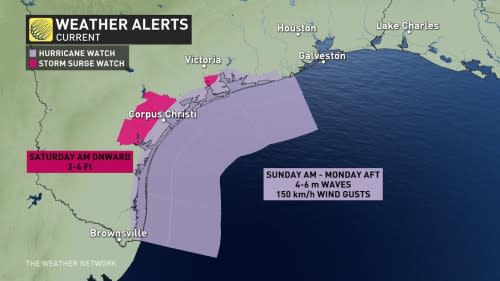
A hurricane watch and a storm surge watch are in effect for the southern half of the Texas coast, including Brownsville and Corpus Christi.
After landfall, it’s likely that the heat dome over the southeastern U.S. will steer Beryl’s remnants over the region. It’s tough to say what, if any, impacts the storm’s remnants could have on Canada since the potential is more than a week out. However, we could watch muggy weather inch northward through the workweek.
Beryl’s historic run
Beryl is a historic storm. Over the past couple of days, the system has set records for:
the earliest Category 5 hurricane on record, beating 2005’s Hurricane Emily
the earliest Category 4 hurricane on record, beating 2005’s Hurricane Dennis
the earliest hurricane so far east in the tropical Atlantic on record
This is also the first time since 1966 we’ve seen a major hurricane before the July 4th holiday.

Experts largely agree that we’re in for a very active Atlantic hurricane season in the weeks and months to come. Sea surface temperatures throughout the Atlantic are running several degrees hotter than normal, closer to what you’d expect in September than the end of June.
MUST SEE: El Niño is over—but La Niña may arrive during peak hurricane season
These abnormally hot waters will combine with the lower wind shear brought on by a developing La Niña in the eastern Pacific to foster extremely favourable conditions for tropical cyclone development through the peak of the season this fall.
The latest seasonal outlooks call for as many as two-dozen named storms, which is far more than the 14 tropical storms we’d see during a typical Atlantic hurricane season.
Stay with The Weather Network for all the latest on this busy hurricane season.

