Hurricane Beryl tracker: See projected path, spaghetti models of storm as it hits Mexico
As Hurricane Beryl moves inland over the Yucatan Peninsula, those in its path can expect strong winds, storm surges and damaging waves, the National Hurricane Center announced Friday morning.
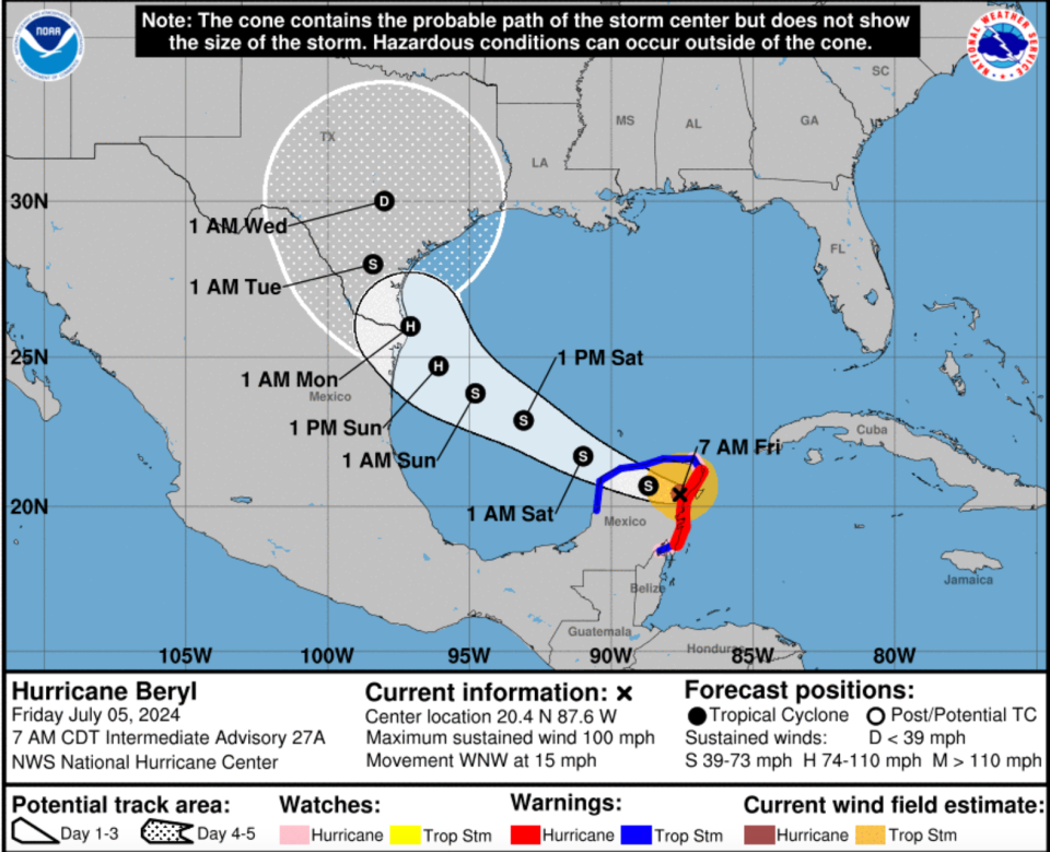
As of Friday morning at 7 a.m. CT, the center of Hurricane Beryl, which downgraded to Category 2, was moving toward the west-northwest at about 15 miles per hour.
The NHC expects the hurricane to make a west-northwestward motion during the next day or so.
The NHC said the hurricane's center should cross the northern Yucatan Peninsula Friday and then emerge over the southwestern Gulf of Mexico later Friday night. By the end of the weekend, the hurricane should move northwestward toward northeastern Mexico and southern Texas.
The hurricane's maximum winds have decreased to about 100 miles per hour, the NHC said. As Hurricane Beryl moves farther inland and crosses the Yucatan Peninsula, winds are expected to rapidly weaken. Still, slow re-intensification is expected once Beryl moves back over the Gulf of Mexico.
Hurricane Beryl live updates: Storm makes landfall again in Mexico. Is Texas next?
According to the NHC, a storm surge could increase water levels by four to six feet above ground level in areas where there are onshore winds along the east coast of the Yucatan Peninsula within the hurricane warning area. Near the coast, the surge will bring large and destructive waves.
Beryl is also expected to bring large swells to eastern Mexico and the Gulf Coast of the U.S. later Friday. The swells can cause life-threatening surf and rip current conditions.
Hurricane Beryl path tracker
This forecast track shows the most likely path of the center of the storm. It does not illustrate the full width of the storm or its impacts, and the center of the storm is likely to travel outside the cone up to 33% of the time.
Hurricane Beryl spaghetti models
Illustrations include an array of forecast tools and models, and not all are created equal. The hurricane center uses only the top four or five highest-performing models to help make its forecasts.
Atlantic storm tracker
How much rain will Hurricane Beryl bring Friday?
According to the NHC, Beryl is expected to produce four to six inches of rainfall Friday, with localized amounts of 10 inches across the Yucatan Peninsula. There may also be scattered flash flooding.
From Sunday into early next week, meteorologists expect heavy rainfall of four to eight inches with locally higher amounts across portions of northeastern Mexico and south Texas.
Hurricane warnings, watches
Hurricane warnings are in effect for the coast of the Yucatan Peninsula of Mexico from Puerto Costa Maya to Cancun, including Cozumel, according to the NHC.
Hurricane warnings are issued when sustained winds of 74 miles per hour or higher associated with a tropical cyclone are expected in 36 hours or less, the National Weather Service said. Hurricane warnings can remain in effect when there is dangerously high water or a combination of dangerously high water and continued high waves, even if winds are less than hurricane force.
There are also hurricane watches in effect for the coast of the Yucatan Peninsula south of Puerto from Costa Maya to Chetumal, and north of Cancun to Cabo Catoche.
Hurricane watches are issued when tropical cyclones containing winds of 74 miles per hour or higher pose a possible threat. The winds may also bring storm surges, coastal flooding or river flooding with them, according to the NWS.
"The watch does not mean that hurricane conditions will occur," the NWS wrote on its website. "It only means that these conditions are possible."
Tropical storm warning
A tropical storm warning is in effect for the coast of the Yucatan Peninsula of Mexico south of Puerto Costa Maya to Chetumal, and the coast of the Yucatan Peninsula of Mexico north of Cancun to Campeche.
Tropical storm-force winds can be up to 105 miles per hour and a storm surge could increase water levels by one to three feet above ground level along the west coast of the Yucatan Peninsula in the tropical storm warningarea.
Contributing: Cybele Mayes-Osterman, Mary Walrath-Holdridge and James Powel, USA TODAY
Saleen Martin is a reporter on USA TODAY's NOW team. She is from Norfolk, Virginia – the 757. Follow her on Twitter at @SaleenMartin or email her at sdmartin@usatoday.com.
This article originally appeared on USA TODAY: Hurricane Beryl path tracker, spaghetti models: Follow the storm

