Hurricane Beryl tracker: Storm makes landfall in Texas. Will it hit Louisiana? See models
Hurricane Beryl made landfall as a Category 1 near Matagorda, Texas early Monday morning.
The storm made landfall 110 miles south of Houston.
The state faces 75 mph winds and life-threatening storm surge. Heavy rainfall, and flash and urban flooding are expected to impact the eastern part of the state, according to the National Hurricane Center.
A tornado watch will remain in effect for southeastern Texas until 10 a.m. local time, states the National Weather Service.
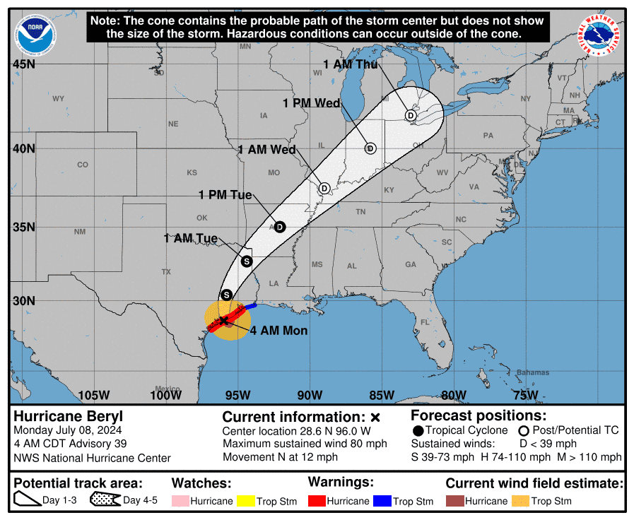
Where will the storm go?
The storm is moving 12 mph north. The following areas can expect to see 3-5 inches of rain tonight into Tuesday:
Southeast Oklahoma
Arkansas
Southern Missouri
Live updates: Forecasters fear Beryl will rapidly strengthen as it heads for Texas
Hurricane Beryl path tracker
This forecast track shows the most likely path of the center of the storm. It does not illustrate the full width of the storm or its impacts, and the center of the storm is likely to travel outside the cone up to 33% of the time.
Hurricane Beryl spaghetti models
Illustrations include an array of forecast tools and models, and not all are created equal. The hurricane center uses only the top four or five highest-performing models to help make its forecasts.
Atlantic storm tracker
Contributing: Anthony Robledo, Gabe Hauari, N'Dea Yance-Bragg, Susan Miller, John Bacon, Jorge L. Ortiz, Dinah Voyles Pulver & Thao Nguyen, USA TODAY; Cheryl McCloud, USA TODAY-Network Florida
This article originally appeared on USA TODAY: Hurricane Beryl tracker: See storm's path, spaghetti models Louisiana?

