Hurricane center ups odds for potential tropical system that could target Florida
ORLANDO, Fla. — The National Hurricane Center gives 50/50 chances for an Atlantic system to form into the season’s next tropical depression or storm with a potential path that could bring it to Florida.
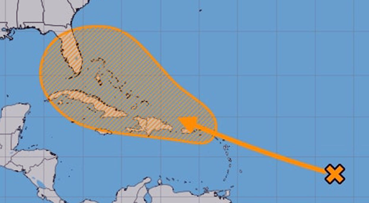
As of the NHC’s 2 p.m. Eastern time tropical outlook Monday, the area of disturbed weather was located over the central tropical Atlantic, but expected to interact with an approaching topical wave in the next two days.
“Environmental conditions are forecast to become conducive for some development thereafter, and a tropical depression could form later this week while the system is in the vicinity of the Greater Antilles or the Bahamas,” forecasters said. “Interests in the Greater Antilles, the Bahamas, and the southeastern U.S. should monitor the progress of this system.”
The NHC gives the system a 50% chance to develop in the next seven days. That’s an increase from Sunday’s predictions.
As far the tropical wave itself, it’s moving west at about 12 mph about 900 miles east-northeast of Antigua and Barbuda, and 1,200 miles east of Puerto Rico.
“Winds and seas associated with a vigorous tropical wave will increase northeast of the Leeward Islands Tuesday night into Wednesday, then move to the north of Puerto Rico and Hispaniola through Thursday.
If it were to gain enough strength, it could become Tropical Storm Debby.
The NHC’s projected potential path cuts a large swath that includes running south over the northern Caribbean islands of Puerto Rico, Hispaniola and Cuba, or curling to the north and running up either Florida’s east coast or along its west coast into the Gulf of Mexico.
“We continue to monitor model trends of an area of interest in the tropics,” said National Weather Service Meteorologist Roby Haley. “Model solutions remain spread far and wide.”
He said both the European ECM model and Canadian forecast models show a more organized system that could run up either coast of the state, while the UKMET model run out of the United Kingdom has it somewhere in the middle.
The often reliable GFS model, though, “has little more than an open wave over the Caribbean,” he said.
Forecast reliability, though, is more difficult to predict before a system gains tropical characteristics such as rotation, and many investigations by the NHC end up never gaining named status.
The 2024 Atlantic hurricane season has had three named storms so far, including Hurricane Beryl, which cut a deadly path from the Caribbean into Mexico and into Texas.
It’s been more than two weeks, though, since the NHC issued advisories on any systems.
The height of hurricane season, though, runs form mid-August into October.
The National Oceanic and Atmospheric Administration forecast an above average year in the Atlantic with 17 to 25 named storms, of which eight to 13 are expected to become hurricanes, and four to seven of those becoming major hurricanes.
Hurricane season officially runs from June 1-Nov. 30.
_____

