Breaking: Potential Tropical Cyclone One could become Alberto by Wednesday
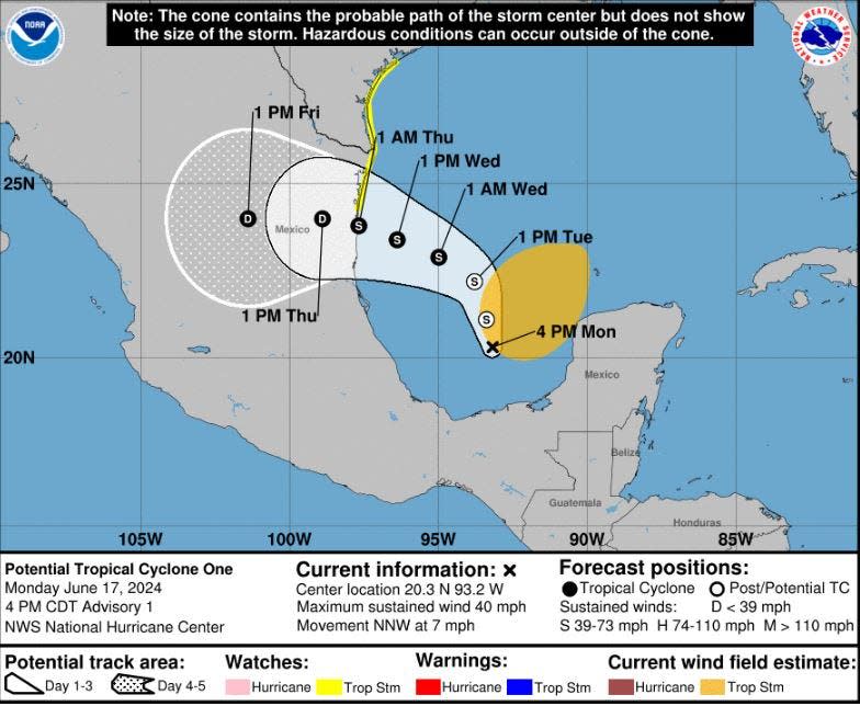
A burgeoning area of low pressure in the Bay of Campeche became Potential Tropical Cyclone One on Monday, and is likely to earn the name Alberto over the next couple of days.
The sloppy swirl about 470 miles southeast of Brownsville, Texas is the first to be identified by the National Hurricane Center this season as a potential tropical cyclone and triggered a tropical storm watch along the Texas coast from Port O-Connor southward to the mouth of the Rio Grande River.
As of Monday afternoon, the system had 40 mph winds and was moving north-northwest at 7 mph. It is not expected to strengthen to a hurricane.
The NHC began labeling potential tropical cyclones in 2017 so that it could issue watches and warnings for systems they believe are going to form near a coastline but haven't yet gained a closed center of low pressure.
The NHC is also watching an area off the east coast of Florida that it is giving a 30% chance of developing over the next seven days. An area of low pressure is expected to form a few hundred miles northeast of the central Bahamas in a day or two and could become a named tropical system as it moves west or west-northwest toward Florida or the southeastern U.S.
2024 Hurricane Season Guide: Storm preparation tips, supplies, evacuation zones, insurance info
The system off the east coast, regardless of development, is expected to inch closer to Florida on Thursday or Friday leading National Weather Service meteorologists in Miami to up the chances of rain to 60% mid week.
But "forecast uncertainty remains very high for this part of the forecast," NWS meteorologists wrote.
2024 hurricane season: 5 tips to stay sane and safe in face of frightful forecast
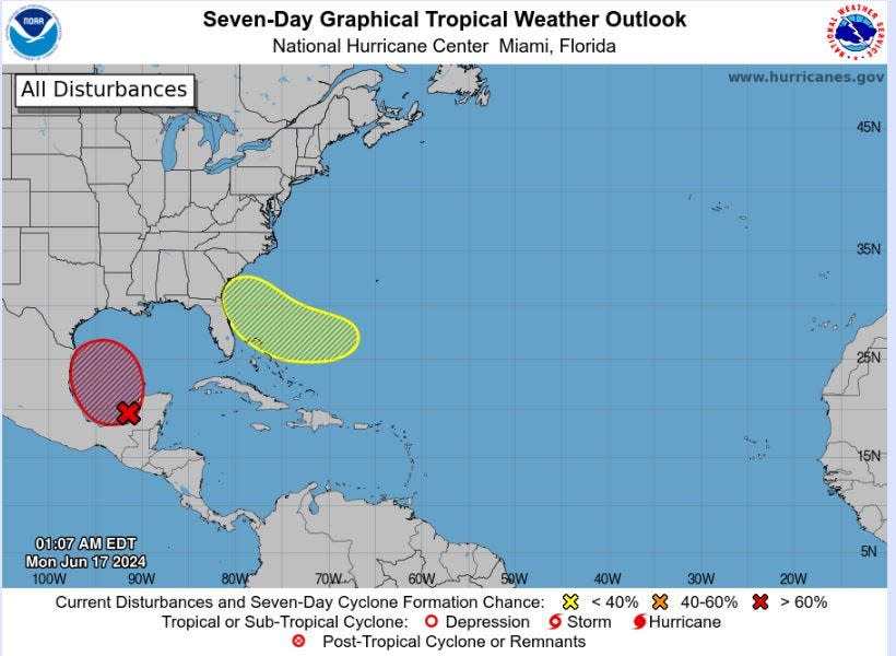
Playing a role in whether the system develops and where it goes is a ridge of high pressure parked over the mid-Atlantic states and another area of low pressure in the western Atlantic Ocean.
"While the exact details still remain very uncertain due to differences in guidance, the potential for heavy downpours for the middle to the end of the week will lead to the potential for localized flooding concerns to return to portions of South Florida," NWS meteorologists wrote.
The soggy forecast follows days of relentless showers last week that left areas of Broward, Miami-Dade and Collier counties with more than 20 inches of rain, flooded streets and triggered a state of emergency declaration from Gov. Ron DeSantis.
Palm Beach County's highest rainfall was measured near Lion Country Safari where over 72 hours about 10.5 inches fell.
Hurricane season 2024: What to do with your boat in Florida if a storm approaches
An Air Force Reserve Hurricane Hunter aircraft was flying to investigate Potential Tropical Cyclone One in the Gulf of Mexico Monday afternoon.
Several days of rainfall are expected from the system regardless of whether it earns a name that NHC forecasters fear could cause "life-threatening" flooding and flash flooding in southern Mexico.
The first names on the 2024 hurricane list are Alberto and Beryl.
Kimberly Miller is a journalist for The Palm Beach Post, part of the USA Today Network of Florida. She covers real estate and how growth affects South Florida's environment. Subscribe to The Dirt for a weekly real estate roundup. If you have news tips, please send them to kmiller@pbpost.com. Help support our local journalism, subscribe today.
This article originally appeared on Palm Beach Post: National hurricane center watching two areas for potential development

