Indiana lost nearly 350k acres of farmland in 12 years, state estimates
Members of the National Association of State Departments of Agriculture gathered in Washington for their annual winter meeting in mid-February. They urged Congress to provide a timely, fully funded farm bill to address a wide range of issues affecting agriculture, including technology, conservation and foreign trade. (Larry Mayer/Getty Images)
Indiana lost about 345,700 acres of farmland to other purposes between 2010 and 2022, but agricultural productivity still increased, the state found in a study released Monday.
Most of it was lost to residential development around the edges of cities and suburban areas, according to the Indiana State Department of Agriculture (ISDA).
“The inventory of lost farmland was an opportunity for ISDA and legislators to gain access to reliable data, where up until now, we could only make assumptions,” agency Director Don Lamb said in a news release.
“This information is important to have for policy development as we work to balance economic growth, food security and the preservation of agricultural land, because we know when agriculture is strong, Indiana is too,” Lamb said.
Lawmakers last year tasked the Indiana State Department of Agriculture with creating the inventory. Rep. Kendell Culp, R-Rensselaer, called his proposal “a food security bill” at the time.
ISDA recommended lawmakers let it update the report, involve local units of government in farmland preservation, and decide on a threshold for an “alarming level” of lost acreage.
“Agriculture is, and always has been, the lifeblood of the Hoosier state,” said Lt. Gov. Suzanne Crouch, Indiana’s secretary of agriculture and rural development. “Data is critical for all levels of government when making decisions that may affect our rural communities and food security.”
The study
ISDA used two data sources: a parcel dataset from Indiana’s Department of Local Government Finance (DLGF) and a cropland data layer dataset from the U.S. Department of Agriculture.
The first showed a total of about 18.31 million acres of land with property class codes in the agricultural range in 2010, and a total of 17.97 million acres in 2022 across the state of Indiana.
That’s a decrease of about 345,700 acres — with cash grain and general farms, as well as specialty crop farms, losing the most. Much of the land was converted to residential, according to the report, and some went vacant.
ISDA also compared 2010 and 2022 data to find the primary drivers of acreage losses and additions. However, researchers found matches for just 85% of parcels.
The cropland data layer, after image generalization processing, showed about 14.84 million acres of land with land classified as any type of agricultural use to in 2010, and a total of 14.18 million acres in 2022.
That’s a difference of 664,988 acres. Most was lost to developed land, but some became forest.
But ISDA said quantity estimates from the second dataset are “likely less reliable.”
The two methods yielded differing results, which the agency said was probably because the datasets categorize agriculture or farmland differently.
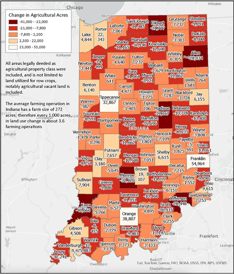
The state’s five biggest farmland losers included Allen, Elkhart, Jefferson, Knox and Monroe counties.
Despite land losses, Hoosier cash crop production is up.
Indiana produced about 597 million bushels of corn for grain in 2012, but over 1 billion in 2022, per the report, which cited USDA yield data. Soybean production also increased from about 219 million bushels of soybeans in 2012 to over 326 million in 2022.
What’s next
The agency didn’t suggest wording for future legislative proposals.
Instead, in a list of recommendations, it asked lawmakers to let it update the inventory every five years, starting with a 2030 report.
“ISDA believes getting on this five-year schedule will be most beneficial as data from the Census of Agriculture will be released again in 2029,” the agency said. The census is a complete count of U.S. farms and ranches and the people who operate them.
It also said lawmakers should involve local units of government in farmland preservation talks, noting that Indiana “is a home rule state.” Land use decisions are made mostly at the local level.
“No two counties are the same and neither are their comprehensive plans, zoning ordinances or land use decisions,” ISDA said. “Local units of government should be empowered to identify land use trends in their area and use all available information when making land use decisions.
But not all communities have plans. They’re not required.
So the agency pushed local units to be “proactive rather than reactive” and to “ensure they have a strategic vision” for the future.
It also suggested lawmakers find a threshold at which shrinking farmland “significantly reduces” access to food — while keeping in mind that technological changes have allowed farmers to produce more on less land.
Finally, it recommended that lawmakers consider prime farmland — the state’s best 12.6 million acres of land — in decision-making.
GET THE MORNING HEADLINES DELIVERED TO YOUR INBOX
The post Indiana lost nearly 350k acres of farmland in 12 years, state estimates appeared first on Indiana Capital Chronicle.

