Invest 92L close to tropical depression status. Florida-Georgia landfall expected later today
- Oops!Something went wrong.Please try again later.
A tropical disturbance — labeled Invest 92L — off Florida could become a short-lived tropical depression before moving onshore later today, according to the latest advisory from the National Hurricane Center.
Forecasters issued a special outlook at 10:35 a.m., saying there is now a well-defined center of circulation and winds are near 35 mph.
It's still not quite a tropical depression, though, since "associated showers and thunderstorms are not quite organized enough for this system to be considered a tropical cyclone.
"However, only a small increase in the organization of the showers and thunderstorms could result in the formation of a short-lived tropical depression before it reaches the coast of northeastern Florida or Georgia tonight."
“I don’t think the area of low-pressure east of Florida is going to have enough time to develop, but it will produce downpours Thursday night and Friday across coastal northern and central Florida," said Bernie Rayno, AccuWeather chief on-air meteorologist.
➤ Tropics watch, June 21: NHC tracking 2 disturbances that could become tropical depressions
The next named storm of the 2024 Atlantic hurricane season will be Beryl.
Invest 92L: National Hurricane Center forecast for system east of Florida

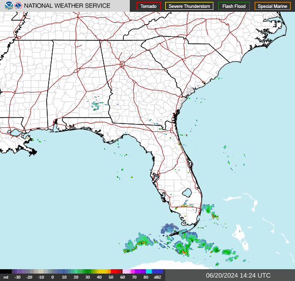
Satellite imagery and National Weather Service Doppler radar data indicate that showers and thunderstorms associated with a well-defined low pressure area centered about 80 miles east-southeast of Brunswick, Georgia, continue to lack the necessary organization for the low to be considered a tropical cyclone.
Recent Air Force Reserve reconnaissance aircraft data indicate that winds to 35 mph are occurring in association with the low. Only a small increase in the organization of the showers and thunderstorms could result in the formation of a short-lived tropical depression before it reaches the coast of northeastern Florida or Georgia Friday night.
Residents in its path are advised to monitor its progress.
Formation chance through 48 hours: medium, 60 percent.
Formation chance through 7 days: medium, 60 percent.
Spaghetti models for Invest 92L as it moves toward Florida, Georgia
Special note about spaghetti models: Illustrations include an array of forecast tools and models, and not all are created equal. The hurricane center uses only the top four or five highest performing models to help make its forecasts.
What is a tropical depression and tropical storm?
For a system to be designated as a tropical depression, it must have a closed center of circulation and sustained winds must be 38 mph or less.
A tropical storm has a closed center of circulation and sustained winds of 39 to 73 mph.
Weathertiger: Invest 92L 'remains proverbial pain in the liver'
#Invest92L east of Jacksonville remains the proverbial pain in the liver that falls just short of jaundice today. Clear circulation & 35+ mph winds, but convection not quite organized enough for NHC to call it a depression.
Showers continue in N FL/E GA into this evening. pic.twitter.com/yFPRd5GThR— WeatherTiger - weathertiger.substack.com (@wx_tiger) June 21, 2024
"Thunderstorm activity with this small area of low pressure remains limited due to a nearby dry airmass, and it probably won’t organize further prior to reaching Florida," said Dr. Ryan Truchelut is chief meteorologist at WeatherTiger.
"However, a slim chance of last-minute development while crossing the Gulf Stream can’t be ruled out, as unlike large storms, the intensity of small systems takes the elevator up (or down).
"Even if a depression or minimal tropical storm briefly forms, impacts on Florida will be little different than a typical day in June. Expect enhanced rain chances along Florida’s Atlantic coast and into North Florida on Thursday and Friday, and continued breezy conditions into the weekend, but that’s about it" Truchelut said.
Truchelut works with the USA TODAY Network-Florida to provide the latest storm information Florida residents need.
Storm sequel on horizon? Alberto targets Texas, 'featherweight' system nears Florida
Heavy rain, gusty winds, dangerous surf possible as Invest 92L nears Florida
"Regardless of development, this feature can bring high seas, gusty winds and areas of heavy rain and thunderstorms to the Southeast coast," said AccuWeather Meteorologist Andrew Kienzle.
Rip currents will increase in strength and frequency from the east-central coast of Florida to North Carolina.
"Within the heavier rain bands, localized flash flooding can occur," AccuWeather Senior Meteorologist Alex Sosnowski said,
Wind gusts directly along the coastline could reach 25-35 mph as the invest moves northwest, AccuWeather said.
Jim Cantore: Invest 92L could become tropical storm after moving back over water
Looks like some deeper convection on the west side is wrapping around some type of center. Should be a fun morning with visible imagery, observations, buoys, Hurricane Hunters, and Doppler radar as a part of our arsenal. 92L actually has a chance at becoming a TS AFTER it goes… pic.twitter.com/HBbg5c7IIX
— Jim Cantore (@JimCantore) June 21, 2024
Jim Cantore, The Weather Channel meteorologist, tweeted Friday morning Invest 92L has a chance of strengthening, but not before moving northeast back over the Atlantic Ocean.
"Looks like some deeper convection on the west side is wrapping around some type of center. Should be a fun morning with visible imagery, observations, buoys, Hurricane Hunters, and Doppler radar as a part of our arsenal.
"92L actually has a chance at becoming a TS AFTER it goes back out over the water and moves northeast over open water if it doesn't do it sooner..."
Watches, warnings issued across Florida, Georgia, South Carolina
Expect rough surf, heavy rainfall, gusts up to 30 mph in Northeast Florida
"Invest 92-L is about 200 miles away from Jacksonville, and will continue to move toward the Northeast Florida/Southeast Georgia coast, with little time to organize further," the National Weather Service Jacksonville said.
"There remains potential (50% chance) of this system developing into a short-lived tropical depression early this morning before making landfall in the late morning/early afternoon hours.
"Tropical depression formation or not, hazards will remain the same: heavy rainfall, gusty winds, and coastal impacts including rough surf, high rip currents, and minor beach erosion during high tide. Areas that have not received rainfall recently will see beneficial rainfall totals around 1-2 inches along and east of I-95 today, with locally higher amounts possible.
"Wind gusts are likely to stay below wind advisory today, with onshore gusts reaching around 30 mph."
High surf advisory: until 5 p.m. June 21. Large breaking waves up to 7 feet.
Rip current risk: Through Friday afternoon. High rip current risk, dangerous rip currents. Expect dangerous swimming and surfing conditions and localized beach erosion.
Radar: See satellite view of Invest 92L
Periods of heavy rain forecast for portions of East Central Florida
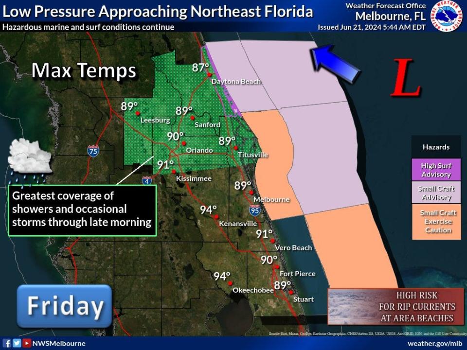
"An area of low pressure will move toward the northeast Florida coast today (Friday)," the National Weather Service Melbourne tweeted.
"Periods of heavy rainfall and occasional storms are forecast through late morning, especially north of Cape Canaveral. Hazardous marine and surf conditions continue."
"Southern Volusia has received the bulk of the rain, with 1-2 inches, locally 2.5 inches overnight. Additional rains will continue to push onshore Volusia and well inland across Lake county this morning."
Bands of heavy rain and isolated storms continue this morning, especially north of Cape Canaveral.
Redevelopment of showers and occasional storms will be possible along and north of the I-4 corridor Friday afternoon.
Locally heavy rains this morning in Volusia, Seminole, and Lake counties. After a break, additional storms possible there later this afternoon.
Expect dangerous swimming and surfing conditions and localized beach erosion.
High surf advisory: until 10 a.m. Friday. Waves 5-7 feet in surf zone in Volusia, Brevard, Indian River, St. Lucie and Martin counties.
Small craft advisories: through Thursday night. East to northeast winds around 20 knots, with gusts up to 25 knots. Seas 6-9 feet.
Rip current risk: Numerous, life-threatening rip currents through late Thursday night.
This article originally appeared on Treasure Coast Newspapers: Invest92L: Expected path, forecast, radar Florida, Georgia

