La Niña could mean an active hurricane season. Here's what it means for Texas this summer
Summer is coming, and so is La Niña.
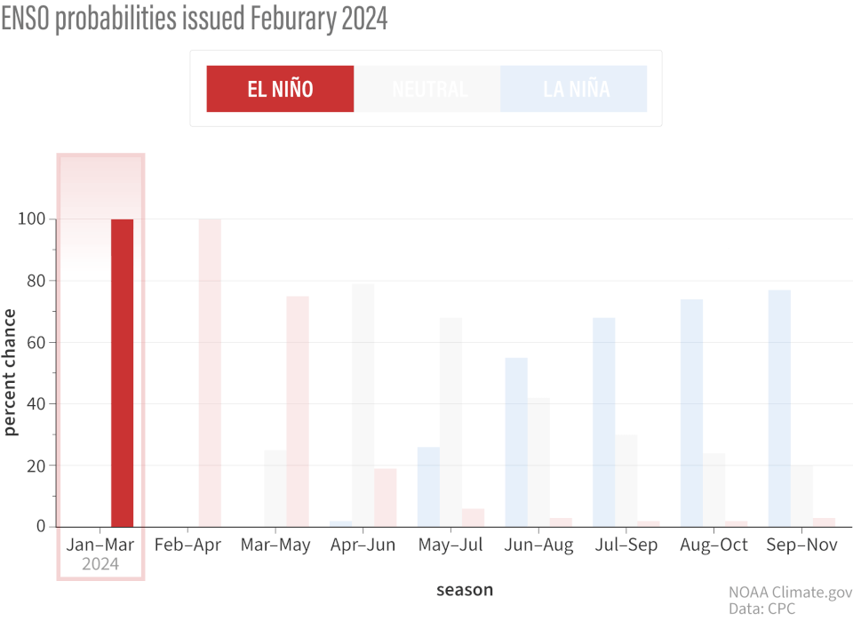
According to the National Weather Service’s Climate Prediction Center, there is a 49% chance of La Niña developing between June and August this year, and forecasters say it will create conditions for an 'above-normal' hurricane season in Texas.
What is La Niña?
La Niña, which means "little girl" in Spanish, is a climate phenomenon characterized by the cooling of sea surface temperatures in the central and eastern equatorial Pacific Ocean. La Niña and its opposite, El Niño, as well as a neutral phase, are part of a larger climate pattern known as the El Niño-Southern Oscillation. The tropical Pacific can be in either one of those three states.
According to scientists, El Niño years tend to bring cold, wet winters to California and the southern U.S. but warm, dry conditions to the Pacific Northwest and the Ohio Valley. La Niña tends to bring the opposite: dry conditions for the whole southern half of the country but colder, wetter weather for the Pacific Northwest.

How does La Niña affect Texas weather?
La Niña has a notable impact on Texas weather, primarily influencing temperature and precipitation patterns. Here's how La Niña typically affects Texas, according to NOAA:
Temperature: La Niña often brings warmer-than-average temperatures to Texas during the winter months. The warmer conditions are a result of the jet stream shifting northward, reducing the frequency of cold air masses moving into the region. Summers during La Niña years can also be hotter than normal, with higher heatwaves and increasing demand for water and energy.
Precipitation: La Niña is usually associated with drier-than-normal conditions across Texas, particularly in the fall and winter months. The northward shift of the jet stream tends to divert storm systems away from the state, reducing the overall rainfall. The reduced precipitation can lead to an increased risk of drought. Texas may experience significant water shortages, affecting agriculture and water supply and increasing the likelihood of wildfires.
Severe weather: Due to warmer temperatures during La Niña winters, the likelihood of severe weather, such as snow and ice storms, is generally lower. However, La Niña can increase severe weather events like tornadoes in Texas due to enhanced instability and favorable atmospheric conditions.
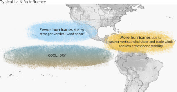
Hurricane season: La Niña can contribute to a more active Atlantic hurricane season. This means Texas might face a higher risk of hurricanes and tropical storms making landfall, bringing heavy rainfall and potential flooding. The NOAA predicts between 17 and 25 named storms this season, with 4 to 7 becoming major hurricanes classified as category 3, 4, or 5.
Texas weather: NOAA predicts 'above-normal' 2024 hurricane season in new outlook
When to expect La Niña
The NOAA predicts a 49% chance of La Niña developing between June and August and a 69% chance between July and September.
This article originally appeared on Austin American-Statesman: La Niña is coming. Here's what it means for Texas weather this summer

