New La Niña forecast not great for SC winter weather this year. Here’s why
Those hoping for relief this winter from the South Carolina drought may be disappointed because of La Niña, the latest forecast shows.
The National Weather Service’s Climate Prediction Center recently issued an updated forecast for La Niña, shifting the chances of the weather pattern forming more toward the fall from previous predictions for the summer. The formation of a La Niña can contribute to drier winters and more severe Atlantic hurricane seasons.
According to the latest forecast, there is a 70% chance of La Niña emerging between August and October. There is also a 79% chance that La Niña will persist during November through January.
The Atlantic hurricane season started June 1 and lasts through November.
What is La Niña?
La Niña is the opposite of El Niño. Trade winds are even stronger than usual during La Niña events, pushing warm water toward Asia. Off the west coast of the U.S., upwelling increases, bringing cold, nutrient-rich water to the surface. These cold waters in the Pacific push the jet stream northward.
La Niña winter weather impacts
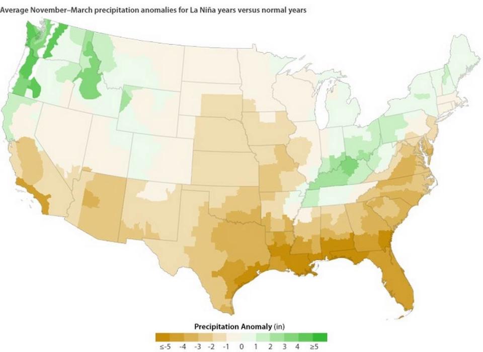
The effects from La Niña tend to trigger drought conditions in the Southeast, according to the National Oceanic and Atmospheric Administration.
“The dryness over the Southeast is often associated with the Pacific-North American (PNA) climate pattern,” NOAA states. “In the pattern’s negative phase, the general flow of the atmosphere gets “stuck” in a wave train that repeatedly brings higher-than-normal pressure to the North Pacific, lower-than-normal pressure to western Canada, and, farther downstream, higher-than-normal pressure to the Southeast. High pressure generally results in dry skies.”
Below is a map that shows the average influence La Niña has had on winter precipitation in the U.S. over the past 60 years.
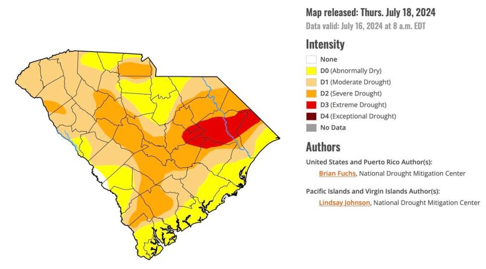
Meanwhile, all of South Carolina is under some level of drought, according to the U.S. Drought Monitor. La Niña will likely exacerbate the problem.
What does La Niña mean for hurricane season?
La Niña is known to enhance hurricane activity in the Atlantic basin, according to NOAA.
NOAA currently predicts an above-normal hurricane season with between 17 and 25 named storms. While the season has had a relatively slow start so far, know that Atlantic hurricane season is usually most active between mid-August and mid-October — the period when La Niña is currently expected to emerge.
Hurricane activity tends to increase under La Niña due to its effects on wind shear and atmospheric conditions over the Atlantic. There is a reduction in wind shear in the tropics when La Niña occurs, which can encourage hurricane development. Wind shear means a change in wind speed and direction with height in the atmosphere.
La Niña also favors greater hurricane activity by decreasing atmospheric stability and reducing the amount of sinking motion in the atmosphere.

