California's wildfires trigger evacuations, threaten homes amid heat wave
- Oops!Something went wrong.Please try again later.
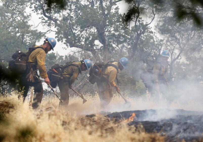
Firefighters in California continued to battle several wildfires across the state on Monday, including one that threatened Neverland Ranch, the onetime home of pop star Michael Jackson, in the Santa Barbara County mountains.
The Lake fire started Friday afternoon and by late Monday had grown to 21,763 acres in the western Los Padres National Forest, where it fed on grass, brush and timber in rugged terrain, according to the U.S. Forest Service.
The fire was 8% contained Monday night, but fire officials noted the fire could grow amid a prolonged heat wave that's lowered moisture in the area and brought gusty winds. Although a smoke column was visible much of the day as the fire burned up Figueroa Mountain, state fire officials said late Monday there had not been significant fire growth throughout the day. Most of the growth was in the southeast portion of the fire.
Over the weekend, firefighters on the ground had a difficult time reaching the blaze due to the enduring heat and challenging terrain, requiring them to use helicopters to contain its spread.
On Sunday, Santa Barbara County expanded its evacuation orders to include Figueroa Mountain Road, also known as the Grass Mountain Trail Head, and neighborhoods within Sawmill Basin, including Tunnel Road and the Figueroa Campground, according to emergency officials.
As of Monday morning, about 20 people had left their homes, according to Jackie Ruiz, a spokesperson for Santa Barbara County's Office of Emergency Management. The evacuation zone also extended to Sycamore Valley Ranch, formerly Neverland Ranch, in Los Olivos. The cause of the blaze is still under investigation.
To the east, an evacuation order was put in place for the Mt. Baldy ski resort in the San Bernardino National Forest due to a wildfire that so far has burned more than 588 acres.
The Vista fire was reported around 1 p.m. Sunday in steep terrain, about a mile from the ski resort and west of the mountain community of Lytle Creek, according to the U.S. Forest Service. Portions of the Pacific Crest Trail were closed from the Lytle Creek area to Mt. Baldy as well as additional trails below the resort. Hundreds of people were evacuated from nearby recreational areas since the fire broke out, according to Nathan Judy with the U.S. Forest Service, but residents in the community of Lytle Creek were still able to reach their homes.
The cause of the fire is under investigation.
Meanwhile, up north, a group of hikers was found Monday after going missing in the zone of a wildfire burning in the Tahoe National Forest.
The Royal fire, near the Royal Gorge in the North Fork of the American River in Placer County, has burned 201 acres since first being reported late Sunday afternoon, according to the California Department of Forestry and Fire Protection.
The Placer County Sheriff's Department said 13 hikers, ages 16 to 20, were believed to be missing in the area of the fire after their vehicles were discovered parked at the Palisades trailhead.
But the group was spotted by helicopter Monday morning, and a search-and-rescue team was set to meet them and escort them out of the area, according to Sgt. Ty Conners with the Placer County Sheriff's Department. The hikers were reported to be in good health, according to officials.
The area where the Royal fire is burning is known for world-class kayaking and hiking, said Battalion Chief Nolan Hale with the California Department of Forestry and Fire Protection. That also means the fire is "sitting in super remote terrain, with steep, unforgiving cliffs and a ton of granite."
Farther north in Butte County, firefighters contained a wildfire that started near the city of Oroville last week. The Thompson fire burned 3,789 acres and forced thousands to flee their homes as extreme heat dogged firefighters and persistent winds fanned the flames. The cause of that fire, which state fire officials said started Wednesday and ultimately destroyed 26 structures and damaged eight others, remains under investigation.
Near the state's northern border in Siskiyou County, Cal Fire reported a new fire late Monday. The Bogus fire began around 4 p.m. in the 10000 block of Little Bogus Creek Road, fire officials said. By Monday evening it had spread to around 200 acres, spurred evacuation orders, and was 0% contained.
At the same time, Siskiyou County has been feeling the effects of the larger Shelly fire, which started July 3 and spread to more than 4,200 acres in the Marble Mountain Wilderness near Shelly Lake and the Pacific Crest Trail. Due to hot dry weather and difficult access, officials said, the fire grew to threaten communities, private timberlands, cultural resources and wilderness areas.
As of Monday evening, one of the largest fires in the state was the Basin fire, which has burned more than 14,000 acres in the Sierra National Forest. The blaze did not increase in acreage on Monday, and fire officials said it was 80% contained by evening. The fire started June 26 and the U.S. Forest Service said its cause was still under investigation.
This story originally appeared in Los Angeles Times.

