Leftovers from Beryl to soak southern Ontario and Quebec with heavy rain
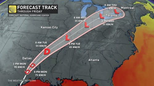
After Beryl made its third and final landfall as a Category 1 hurricane early Monday morning near Matagorda, Texas, the remnant moisture associated with the once powerful storm will make its way north of the border this week.
Beryl began to quickly weaken as it moved inland on Monday while still bringing significant rainfall and flooding to Texas, resulting in at least two deaths.

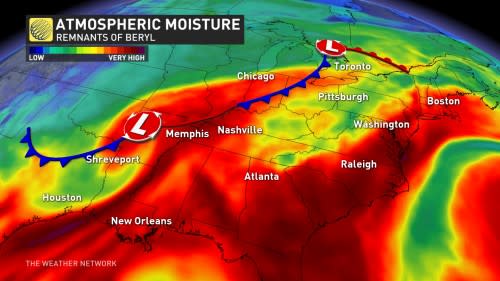
On Tuesday, only a low-pressure system will remain of the historic storm. By the time the low reaches the Mississippi Valley, an upper-level trough in the atmosphere over the central states will capture and fling the moisture towards southern Ontario and Quebec.
Check out The Weather Network’s hurricane hub for all the latest on storms near Canada and around the world
Southern Ontario and Quebec feels Beryl's remnants on Wednesday and Thursday
The earliest we can expect this moisture-packed low to reach the provinces is on Tuesday overnight, then ramping up Wednesday morning. Eastern Ontario and Quebec can expect to see rainfall by early Wednesday afternoon. It will file in from the south, through the Ohio Valley, over Lake Erie, and move northward in waves through Thursday.
RELATED: Tropical Storm Beryl kills two, knocks out power as it churns across Texas
While driven by an upper-level trough, at the surface, the system will send a warm front through southern Ontario and Quebec. Around this front is where we expect to see the heaviest rain fall, as well as the risk of thunderstorms.
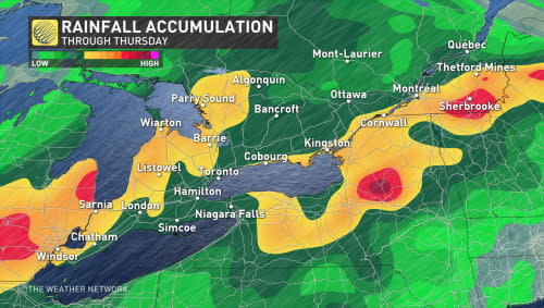
At this time, it's too soon to give precise rainfall totals for the provinces, but localized forecasts are expected to exceed 50 mm through Thursday. There is also a degree of uncertainty as to where the most rainfall will be.
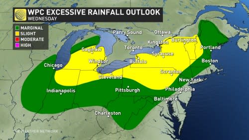
Currently, computer models are suggesting the 401 corridor may be the subject to the highest totals, but this could change leading up to the event.
DON'T MISS: Canadian Red Cross launches appeal to help people impacted by Hurricane Beryl
It can be easy to think that southern Ontario and Quebec is going to be struck by a hurricane-force storm when we say that the remnants of Beryl will reach the provinces. We can assure you, though, that is not the case. Hurricanes need warm oceanic water to sustain themselves and will deteriorate rapidly when starved of that fuel.
By the time this system reaches southern Ontario and Quebec, it won't even be a tropical depression by then.
What we will see is a tropical moisture-laden low-pressure system. The main risks presently with this system in Ontario and Quebec will be heavy downpours, the risk of thunderstorms, and localized flooding.
The localized flooding from heavy downpours could also cause a significant amount of storm water runoff to make its way into Lake Ontario, raising the lake's pollution levels.
Not the first time
This isn't the first time Ontario and Quebec has felt the lingering impacts of a tropical system.
The hurricane database has 50 cases of remnant storms or tropical depressions moving across southern Ontario since 1876, with only seven of them landfalling in Texas.
Yes, the best track proxy for this setup is Hurricane Ike back in September 2008, a Texas landfalling storm. Of course, Sandy is a prime example of how strong a storm can become once its fully extratropical, occurring in October of 2012.
As well, Hurricane Fran's impacts were felt in southern Ontario in September of 1996 when the then-tropical depression dumped 66.4 mm of rain at Toronto Pearson International Airport.
SEE ALSO: Beware! These dangerous plants are found in Canada
More recently, remnants of Hurricane Isabel dumped more than 30 mm at Pearson airport in September of 2003.
Alberto in May 2018 was also an incredible rarity as the National Hurricane Center kept the storm a tropical depression as it crossed Manitoulin Island on May 31, 2018.
In 2020, Tropical Storm Cristobal made an incredibly rare feat, with tropical remnants crossing Lake Superior on June 10, 2020. The system held onto tropical characteristics into southern Wisconsin.
Stay with The Weather Network for more forecast information and updates on your weather across Ontario and Quebec.

