I-29 fully reopened to Iowa state line after flooding, SD DOT says
- Oops!Something went wrong.Please try again later.
Update as of noon Sunday: The city of Sioux Falls is no longer asking residents to conserv water usage.
"Thank you for your willingness to do your part and help our wastewater collection and treatment systems," the city posted on its Facebook page. "The City's wastewater collection and treatment systems remain strained, but they are slowly catching up and are back to a point where we believe it is manageable."
Update as of 2:15 p.m. Saturday: I-29 has fully reopened both northbound and southbound from Sioux Falls to the South Dakota/Iowa state line.
"Some water currently remains on the outside shoulders but water levels are continuing to drop throughout the day," SD DOT posted on social media.
Update as of noon Saturday: Southbound Interstate 29 has partially reopened. One lane of southbound Interstate 29 has reopened to traffic from Sioux Falls to the South Dakota/Iowa state line, according to the SD Department of Transportation.
Southbound Interstate 29 Partially Reopened to Traffic
(Saturday, June 22, 2024 - Update #2)
One lane of southbound Interstate 29 has reopened to traffic from Sioux Falls to the South Dakota/Iowa state line.
Please visit https://t.co/jAj5PbAmq4 pic.twitter.com/y6Wqy8lJS8— SDDOT (@SouthDakotaDOT) June 22, 2024
Update as of 9:45 a.m. Saturday: Gov. Kristi Noem, joined by Mayor Paul TenHaken, Secretary of Public Safety Bob Perry and other emergency response professionals, said state and city authorities are preparing for regional water systems in eastern and southeastern South Dakota to see their highest water loads over the next several days.
Noem said the flooding event's "crest" — the highest level of water flows — is expected to hit the region's rivers and streams Monday and Tuesday, depending on the area.
Here's when water levels are expected to see their highest levels, per Noem:
Big Sioux River: 7 a.m. Tuesday at 38.4 feet;
James River: Sometime Monday or Tuesday at 25.1 feet;
Vermillion River: Tuesday morning at 30 feet.
"That's really when we're gonna see the bulk of that water moving through the system, and we're working to be prepared for that," Noem said.
More: Gov. Noem, state officials say eastern SD river levels expected to peak Monday and Tuesday
Even though the rain is slowing down, we need to keep vigilant. The worst of the flooding along our rivers will be MONDAY and TUESDAY.
This is the briefing that I provided from SD to our statewide media this morning: pic.twitter.com/G7lnJDwQYc— Kristi Noem (@KristiNoem) June 22, 2024
Update as of 6:45 a.m. Saturday: The NWS says the severe weather threat and flood threat has diminished greatly, but scattered showers and isolated storms are expected through early this afternoon.
"Continue to heed travel advisories; do not drive through flooded roadways and do not drive around barricades," the NWS stated on social media.
The flood watch for Minnehaha and Lincoln counties has extended to 7 p.m. Saturday, and the flood warning has now been extended to 9:45 a.m. Sunday, according to NWS.
"Extensive street flooding and flooding of creeks and rivers are possible," the watch states. "Area creeks and streams are running high and could flood with more heavy rain. This area has already experienced several days of extreme rainfall and is experiencing significant ongoing flooding. Additional thunderstorms this afternoon may bring an additional 0.5 inches of rainfall, further exacerbating flooding."
Saturday Morning Radar Loop | 6:30 AM
Scattered showers and isolated storms are expected through early this afternoon. Continue to heed travel advisories; do not drive through flooded roadways and do not drive around barricades. pic.twitter.com/ajhb0MPFpW— NWS Sioux Falls (@NWSSiouxFalls) June 22, 2024
Update as of 11:50 p.m. Friday: The flood warning for parts of Lincoln and Minnehaha counties has been extended to 9:45 a.m. Saturday, according to NWS.
"At 11:04 p.m., emergency management reported heavy rain in the warned area due to thunderstorms," the warning now states for Minnehaha County. "Flooding is ongoing or expected to begin shortly. Between 6 and 10 inches of rain have fallen. Additional rainfall amounts of 1 to 3 inches are possible in the warned area."
Those areas include: Sioux Falls, Worthington, Madison, Luverne, Pipestone, Brandon, Hartford, Flandreau, Fulda, Crooks, Adrian, Edgerton, Garretson, Wall Lake, Baltic, Valley Springs, Colton, Hills, Jasper and Colman.
For Lincoln County, the warning states between 8 and 16 inches of rain have fallen. Additional rainfall amounts of 1 to 4 inches are possible in the warned area.
That area includes: Sioux Falls, Sioux Center, Sheldon, Canton, Sibley, Rock Rapids, Beresford, Parker, Harrisburg, Tea, Rock Valley, Hull, Lennox, Sanborn, George, Centerville, Worthing, Larchwood, Inwood and Viborg.
Update as of 11:30 p.m. Friday: The City of Sioux Falls is asking residents to conserve water until further notice because flooding and heavy rains are straining the city's wastewater treatment system, which is currently running at or near its maximum capacity.
We are asking residents to help us out by conserving wastewater when they can until further notice:
• Reduce shower time or wait to take one until later on Saturday
• Avoid running the dishwasher
• Wait to do laundry
• Conserve water use when possible— City of Sioux Falls (@CitySiouxFalls) June 22, 2024
Update as of 11 p.m. Friday: Gov. Kristi Noem is expected to hold a virtual 7 a.m. press conference Saturday about flood conditions across the area, according to a press release from her office late Friday night.
Noem will be joined by Mayor Paul TenHaken, Secretary of Public Safety Bob Perry and other emergency response professionals, the release states.
~STAY HOME~DO NOT TRAVEL IN LINCOLN COUNTY. Deputies, Conservation Officers, and local Fire Departments are all busy with calls and rescues. If you end up in the water we may not be able to get to you!
Posted by Lincoln County Sheriff's Office Canton, SD on Friday, June 21, 2024
Update as of 10:30 a.m. Friday: The flash flood warning for parts of Lincoln County and Minnehaha County, including Harrisburg, Lennox and Canton, has been extended to 1 a.m., according to NWS.
"At 10:27 p.m., emergency management reported thunderstorms producing heavy rain across the warned area," the warning states. "Between 4 and 6 inches of rain have fallen. Additional rainfall amounts of 1 to 3 inches are possible in the warned area. Flash flooding is already occurring."
Interstate 29 remains blocked at exit 50 (Centerville) and exit 62 (Canton). An alternate route has been created in conjunction with the Iowa Department of Transportation and the Minnesota Department of Transportation.
Full Press Release: https://t.co/9uqP6Z5jKm #SDDOT #SD511 pic.twitter.com/tOvticin5c— SDDOT (@SouthDakotaDOT) June 22, 2024
Areas impacted inclide: Canton, Harrisburg, Lennox, Centerville, Worthing, Inwood, Viborg, Irene, Hurley, Mayfield, Davis and Lake Alvin State Recreation Area.
The warning affects more than 13,300 people.
"Life threatening flash flooding of creeks and streams, urban areas, highways, streets and underpasses," is expected, according to the warning.
Flash Flood Warning continues for Harrisburg SD, Canton SD and Centerville SD until 1:00 AM CDT pic.twitter.com/otCI2pyOqr
— NWS Sioux Falls (@NWSSiouxFalls) June 22, 2024
Update as of 7:40 p.m. Friday: A flash flood warning including Sioux Falls, Yankton and Brandon, has been issued until 11:30 p.m., per NWS.
Flash Flood Warning including Sioux Falls SD, Yankton SD and Brandon SD until 11:30 PM CDT pic.twitter.com/3QtGxMB4bV
— NWS Sioux Falls (@NWSSiouxFalls) June 22, 2024
Update as of 7:15 p.m. Friday: The NWS states showers and thunderstorms will continue to roll through during the the next few hours, bringing periods of moderate to heavy rainfall.
"Additional accumulations between 3-4 inches with pockets of up to 6+ inches are expected with the developing activity," the NWS stated on social media.
Developing showers and thunderstorms will continue to fill in over the next few hours bringing periods of moderate to heavy rainfall.
Additional accumulations between 3-4 inches with pockets of up to 6+ inches are expected with the developing activity. pic.twitter.com/586KOMIFWt— NWS Sioux Falls (@NWSSiouxFalls) June 22, 2024
Update as of 5:45 p.m. Friday: A severe thunderstorm warning has been issued for northwestern Minnehaha County.
"A severe thunderstorm was located over Orland, or 9 miles south of Lake Herman State Park, moving east at 25 mph," the warning states. "60 mph wind gusts and half dollar size hail. ...Hail damage to vehicles is expected. Expect wind damage to roofs, siding, and trees."
Update as of 5:30 p.m. Friday: The day's flash flooding has caused higher than usual water levels at Falls Park in downtown Sioux Falls. The city offered these reminders:
Do not climb on wet rocks.
Keep a safe distance away from the water.
Follow posted safety signs at the park.
Today's flash flooding has resulted in higher than usual water levels at Falls Park. A few reminders:
• Do not climb on wet rocks.
• Keep a safe distance away from the water.
• Follow posted safety signs at the park.
Visit https://t.co/Xun1sCQ91i for more resources. pic.twitter.com/emlSYwBtMl— City of Sioux Falls (@CitySiouxFalls) June 21, 2024
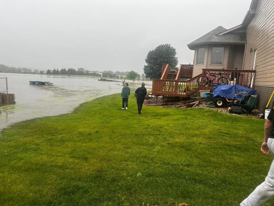
Update as of 5 p.m. Friday: Water levels at Lake Alvin have reached the point where the lake’s spillway is submerged, and water is being sucked underneath a nearby road, flowing east. A visible whirlpool can be seen less than 25 feet from the road, an Argus Leader reporter observed.
Water levels at Lake Alvin have reached the point where the lake’s spillway is submerged, and water is being sucked underneath a nearby road + flowing east. A visible whirlpool can be seen ~25 ft from the road. pic.twitter.com/GW9I5OWERT
— Dominik Dausch (@DomDNP) June 21, 2024
Update as of 4:15 p.m. Friday: The South Dakota Department of Transportation is asking motorists to avoid travel in the southeastern part of the state. I-29 is already closed between exit 59 and exit 64, and more closures, including parts of I-90, are expected as heavy rain returns to the area Friday evening.
The Sioux Falls area is currently forecast to see another 1.5 to 3 inches of rain between 7 p.m. Friday and 1 p.m. Saturday. A slight chance of severe storms is possible throughout the evening, according to the National Weather Service.
Heavy rainfall is again likely this evening and overnight.
The greatest risk overnight will be in portions of Southeast South Dakota and Northwest Iowa.
Be weather aware and watch for flash flood warnings! pic.twitter.com/Kt1JXaTVuj— NWS Sioux Falls (@NWSSiouxFalls) June 21, 2024
Update as of 3:45 p.m. Friday: On top of the flood warnings and flood watch in place, the NWS has issued a severe thunderstorm watch until 11 p.m. Friday for the following counties in South Dakota:
Bon Homme
Clay
Lincoln
Turner
Union
Yankton
A couple tornadoes are possible, along with 70 mph wind gusts and hail up to 2 inches in diameter, the watch states.
A severe thunderstorm watch has been issued for parts of Iowa, Minnesota, Nebraska and South Dakota until 11 PM CDT pic.twitter.com/KwqDQ1iWK5
— NWS Sioux Falls (@NWSSiouxFalls) June 21, 2024
Update as of 1 p.m. Friday: "Rapidly rising floodwaters are submerging docks on Wall Lake, making for unsafe boating," according to the Minnehaha County Sheriff's Office on social media. "Dock decks are floating in scattered areas of the lake."
Rapidly rising floodwaters are submerging docks on Wall Lake making for unsafe boating. Dock decks are floating in scattered areas of the lake. pic.twitter.com/o56uOeRUzM
— Minnehaha Sheriff (@MinnehahaCounty) June 21, 2024
Update as of 12:45 p.m. Friday: More than a dozen city parks and recreational buildings have closed in Sioux Falls, according to the city's website.
You can find a full list here. Wild Water West Waterpark has also closed for the day due to significant flooding.
And as sections of Sioux Falls and Minnehaha and Lincoln county are put under ongoing flash flood warnings, flood warnings and flood watches, roads in Sioux Falls and the surrounding area are closing.
For a full list, check here.
More: Sioux Falls city parks, Wild Water West close due to 'significant flooding'
Update as of 11:45 a.m. Friday: A flood watch is in effect through 7 a.m. Saturday for all of southeastern South Dakota, and a flood warning is currently in effect for the following areas until 7:30 a.m. Saturday, according to NWS:
Portions of northwest Iowa, including the following counties, Clay, Dickinson, Lyon, O`Brien, Osceola and Sioux
Southwest Minnesota, including the following county, Nobles
And southeast South Dakota, including the following counties, Lincoln, Turner and Union
National Weather Service director Todd Heitkamp said there are too many flash flood warnings to name at this time, and that anyone living in an area not in a flood warning, should consider themselves in a flood watch as the heaviest rain will come after 5 p.m. Friday.
The most impacted areas will be south of Interstate 90 and east of Highway 81 in South Dakota, Heitkamp said.
“Whatever rain we get, no matter what amounts, it’s going to add to the problems that already exist and make matters worse,” Heitkamp said. “The main thing that people need to remember is just to stay abreast of the weather conditions and be prepared to take action if your area begins to flood.”
Heitkamp said if you don’t have to travel, especially in areas like Lincoln County and others with a lot of water, don’t travel.
"Additional rainfall amounts of 1 to 4 inches are possible in the warned area over the next 24 hours," the flood warning states.
Locations that will experience flooding include: Sioux Falls, Sioux Center, Sheldon, Canton, Sibley, Rock Rapids, Beresford, Parker, Harrisburg, Tea, Rock Valley, Hull, Lennox, Sanborn, George, Centerville, Worthing, Larchwood, Inwood and Viborg.
A flood warning has been issued for the Big Sioux River at Brandon affecting Lincoln, Minnehaha and Lyon counties, but it's unclear when the warning is expected to expire.
The Lincoln County Courthouse is also closed due to flooding in Canton.
⚠️NO TRAVEL ADVISED⚠️Per the Lincoln County Highway Department, no travel is advised in Lincoln County. There are...
Posted by Lincoln County Sheriff's Office Canton, SD on Friday, June 21, 2024
Update as of 11 a.m. Friday: After hours-long flood warnings that lasted through 9 a.m, multiple roads have been closed throughout Minnehaha and Lincoln counties as rivers and creeks flow over.
In Sioux Falls, 3 to 5 inches of rain fell across the city, which has lead to ponding on roadways and even some road closures, according to the NWS. In Canton, where the flood warning lasted eight hours, the city experienced the highest rainfall so far for the area, with 7.75 inches, NWS states.
Both Beaver Creek and the Big Sioux River above Canton have reached major flood levels, according to the NWS Regional River Status map.
More: Emergency crews rescue campers out near Huset's Speedway after overnight flooding
Meanwhile, emergency crews have had to rescue RVers out near Huset's Speedway after Split Rock Creek overflowed overnight, while campers were waiting for races to continue this weekend as stormes passed.
To check road conditions, visit www.sd511.org, or pay attention to city and county social media pages.
Zooming into Sioux Falls, 3 to 5 inches of rain fell across the city which has lead to ponding on roadways and even some road closures.
Canton, SD has reported the highest rainfall so far with 7.75 inches! pic.twitter.com/5yHO3kJw68— NWS Sioux Falls (@NWSSiouxFalls) June 21, 2024
Update as of 1:30 a.m. Friday: Parts of Sioux Falls and areas in Minnehaha and Lincoln County are under flash flood warnings for the next nearly six hours or more, according to the NWS.
The following areas are under the warning until 9:15 a.m.: Canton, Rock Rapids, Parker, Lennox, Freeman, George, Worthing, Larchwood, Inwood, Marion, Viborg, Menno, Doon, Little Rock, Hurley, Lester, Chancellor, Alvord, Monroe and Clayton.
At 12:59 a.m., the NWS Doppler radar indicated thunderstorms producing heavy rain across the warned area. Between 1 and 5 inches of rain have fallen. Additional rainfall amounts of 1 to 4 inches are possible in the warned area, the warning states.
The storms in the warned area are expected to bring "life threatening" conditions to creeks and streams, urban areas, highways, streets and underpasses, the warning states.
Flash Flood Warning continues for Canton SD, Rock Rapids IA and Lennox SD until 9:15 AM CDT pic.twitter.com/8JsjrdMQdi
— NWS Sioux Falls (@NWSSiouxFalls) June 21, 2024
A warning for the following locations is expected to last until 6:15 a.m.: Sioux Falls, Brandon, Harrisburg, Tea, Hartford, Crooks, Garretson, Wall Lake, Baltic, Valley Springs, Colton, Sherman, Renner, Ellis, Corson, Lyons, Dell Rapids, Rowena, Palisades State Park and Lake Alvin State Recreation Area.
"Flash flooding of small creeks and streams, urban areas, highways, streets and underpasses as well as other poor drainage and low-lying areas," is expected, this warning states.
We are receiving reports of flooded roadways in Sioux Falls. Estimates vary between 2 and 5 inches deep in places. Please do not drive through flooded roads! You never know if they have been washed out under the water.
If you have reports, please send them to us. Pics = bonus— NWS Sioux Falls (@NWSSiouxFalls) June 21, 2024
Update as of 10 p.m. Thursday: The flood watch for the area continues as parts of the Bic Sioux River along Interstate 90 and Skunk Creek in Sioux Falls start to see minor to moderate flooding, according to the NWS Regional River Status map.
The recreation trail has also been closed at Spencer Park due to flooding, along with Spencer Park itself, according to the Sioux Falls Parks and Recreation's page on X.
🚧 Recreation Trail closed at Spencer Park due to flooding, Spencer Park also closed due to flooding 🚧 pic.twitter.com/fuK8DoZnTx
— Sioux Falls Parks & Recreation (@SiouxFallsParks) June 21, 2024
In Lincoln County, Canton has seen significant flooding with dozens of residents rushing to place sandbags along 15 to 20 homes across the town, which is the county's seat and has a population of more than 3,000.
More: Residents rush to put sandbags out as Canton sees first major flood in 10 years
This video, from community organizer and retired EMS volunteer Laurel Laubach shows the scramble in Canton tonight as residents try to save homes. pic.twitter.com/AAI8mrkBCP
— Shelly Conlon (@Shelly_Conlon) June 21, 2024
Update as of 7 p.m. Thursday: Volunteers with the Canton Fire Department, along with other residents, are helping those near Christmas Lake in Canton, as well as Cedar Street, bag and pile sand bags around their homes as waters continue to rise, according to resident Laurel Laubach.
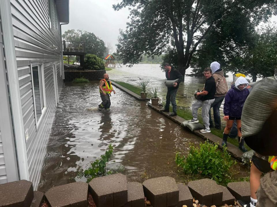
Laubach has been using social media to help spread the word and organize part of the effort for those in need. She's a retired EMS volunteer for the last 20 years, and her husband Nate Laubach, is the chief of the Canton Fire Department.
Update as of 6 p.m. Thursday: The Lincoln County Sheriff's Office has reported flooding over several roads throughout the county. And some residents have reported needing sand bags as water approaches their yards.
"Conditions are expected to get worse," the office said in a statement on Facebook. "Please use caution."
Multiple rounds of showers & T-Storms with potential to produce heavy downpours are expected to continue through SAT. With soils at or near saturation, a Flood Watch has been issued for most of the region through 7am SAT. Graphic w/ totals expected through FRI Noon & Severe risk pic.twitter.com/nNyrwGsUqI
— NWS Sioux Falls (@NWSSiouxFalls) June 20, 2024
The roads include:
276/472
285/476
469/278
278 west of Lennox
⚠️-ALERT-⚠️The Lincoln County Highway Department is reporting flooding on several roads throughout the county. ...
Posted by Lincoln County Sheriff's Office Canton, SD on Thursday, June 20, 2024
Meanwhile, the Tea Area Police Department has reported on its Facebook page that 272nd Street is closed at Heritage Parkway and Summitt Avenue because of flooding.
Beaver Creek in Canton is experiencing minor flooding, while parts of the Vermillion River are experiencing minor to moderate flooding, according to the NWS Regional River Status map.
Update as of 4:15 p.m. Thursday: The NWS is urging drivers to use caution on their commutes home Thursday evening.
"A band of showers and storms producing a half an inch to an inch of rain per hour will move across the Sioux Falls metro through the evening commute," the NWS stated on X. "This will lead to ponding of water on roads."
The band is headed northward, from the area where the flash flood warning was issued earlier.
Use caution driving! A band of showers and storms producing a half an inch to an inch of rain per hour will move across the Sioux Falls metro through the evening commute. This will lead to ponding of water on roads. pic.twitter.com/jEAhBvWCiI
— NWS Sioux Falls (@NWSSiouxFalls) June 20, 2024
Update as of 3:45 p.m. Thursday: A flash flood warning has been issued until 6:45 p.m. for areas including Canton, Lennox and Freeman, according to the NWS.
Flash Flood Warning including Canton SD, Lennox SD and Freeman SD until 6:45 PM CDT pic.twitter.com/s1nKHKBcQd
— NWS Sioux Falls (@NWSSiouxFalls) June 20, 2024
Earlier story: Severe storms and heavy rainfall are expected to continue the next few days in southeastern South Dakota, increasing the risk of flooding, according to the National Weather Service.
The NWS issued a flood watch from 8 p.m. Thursday through 7 a.m. Saturday morning for Minnehaha and Lincoln counties. By Saturday, storms are predicted to bring 2 to 4 inches of rainfall in the area, with a few cases of 6 inches or more.

According to an NWS post on X, formerly known as Twitter, Sioux Falls has already accumulated 0.51 inches of rainfall in the past 24 hours. The heavy rainfall may lead to flooding in urban areas and in creeks and streams.
“The soils are becoming slightly saturated, so they can't hold much more water, especially in rural areas,” said Tim Masters, a hydro-meteorological technician with NWS. “And in the urban downtown areas where there's a lot of concrete, there's becoming drainage issues when the water comes down so hard.”
When will the rain end?
Storms with chances of heavy rain, hail and damaging wind are possible 8 p.m. to midnight Thursday in southeastern South Dakota.
The second round of storms is expected to hit Friday evening. From 6 p.m. to midnight Friday, scattered severe storms are possible in southeastern South Dakota, with a chance of heavy rainfall, hail, damaging winds and isolated tornadoes.
Here's a look at rainfall so far today at a handful of places.
Amounts vary widely, depending on if 1 or 2 thunderstorms really dumped at each spot, or missed some locations.
Additional rainfall continues into tonight and Friday, with localized flooding possible. pic.twitter.com/bXTIOkmXPc— NWS Sioux Falls (@NWSSiouxFalls) June 20, 2024
What to do if waters rise:
In the case of severe storms, Masters says, the most important thing to know is where to go if a warning is issued. If you are camping, locate the severe weather shelter, and if you live in a valley or near a river, find higher elevation during a flood.
How's the rest of the weekend look?
Here’s the forecast for the rest of the week from the NWS as of 4:15 p.m. on June 21.
Friday: A chance of showers and thunderstorms, then showers and possibly a thunderstorm after 5pm. Steady temperature around 72. East wind around 10 mph. Chance of precipitation is 80%. New rainfall amounts of less than a tenth of an inch, except higher amounts possible in thunderstorms.
Friday night: Showers and thunderstorms, mainly before 3am. Some of the storms could produce heavy rainfall. Low around 68. East wind 5 to 10 mph becoming south after midnight. Chance of precipitation is 100%. New rainfall amounts between 1 and 2 inches possible.
Saturday: A 40 percent chance of showers and thunderstorms, mainly before noon. Cloudy, then gradually becoming mostly sunny, with a high near 77. North northeast wind 5 to 10 mph becoming northwest in the morning.
Saturday Night: Mostly clear, with a low around 62. West northwest wind 5 to 10 mph.
Sunday: Sunny, with a high near 83. Calm wind becoming west southwest around 5 mph in the afternoon.
Sunday Night: A 20 percent chance of showers and thunderstorms after 1am. Mostly clear, with a low around 67. East southeast wind around 5 mph.
Monday: Sunny, with a high near 92.
Monday Night: A 40 percent chance of showers and thunderstorms. Mostly clear, with a low around 71.
Tuesday: Sunny, with a high near 86.
Tuesday Night: Mostly clear, with a low around 61.
Wednesday: Sunny, with a high near 80.
Wednesday Night: Mostly clear, with a low around 61.
Thursday: A 30 percent chance of showers. Mostly sunny, with a high near 83.
Thursday Night: A 50 percent chance of showers and thunderstorms. Partly cloudy, with a low around 66.
Friday: A 30 percent chance of showers and thunderstorms. Mostly sunny, with a high near 83.
Stay with the Argus Leader and refresh this page for updates. Kathryn Kovalenko is an intern for the Argus Leader, paid for by a grant program through Bethel University this summer.
This article originally appeared on Sioux Falls Argus Leader: Weather updates: I-29 fully reopened to Iowa state line after flooding, SD DOT says

