Map shows if you’re in an extreme heat risk on Tuesday

(NEXSTAR) — Millions of Americans woke up Tuesday morning still trapped in an unrelenting heat dome, keeping many under the highest level of heat risk on a National Weather Service scale.
The current heat dome is bringing record-breaking heat to the Midwest, Great Lakes, and Northeast this week and could even stretch into next week in some regions.
“The duration of this heat wave is notable and potentially the longest experienced in decades for some locations,” the NWS said in a tweet Monday. In a Tuesday update, the NWS said high temperatures could reach into the mid- to upper 90s.
What is a heat dome, and are you in one?
The suffocating heat has put residents in eight states under an ‘extreme’ risk, the highest possible level on the NWS’s experimental HeatRisk index.
What is HeatRisk?
The HeatRisk tool launched by the NWS follows a five-point scale that ranks the risk of heat-related impacts nationwide. It takes into account how unusual the high temperatures are for the time of year, how long the heat will last through the day and night, and if the temperatures “pose an elevated risk of heat-related impacts” according to data from the Centers for Disease Control and Prevention.
It does not take into account humidity due to a lack of weather stations nationwide tracking humidity, according to the NWS. It also does not replace heat warnings issued by the NWS. Instead, it’s intended to be supplementary.
The HeatRisk scale
There are five levels on the HeatRisk index, ranging from zero to four, each with its own color. You can see the full scale below.
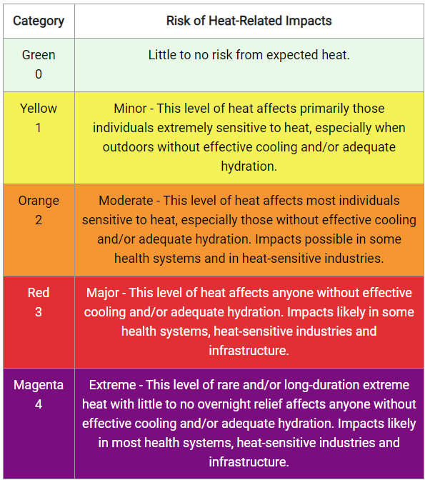
At the bottom is, of course, zero, denoted on the HeatRisk map in green (more on this in a moment). Based on the NWS’s calculations, these areas are expected to see “little to no risk” from forecasted heat.
One step up is category one, represented in yellow and considered minor. A category two risk, marked in orange, is defined as moderate. Category three, shaded red, is a “major risk,” while category four, the magenta level, is extreme.
What is my HeatRisk level for Tuesday?
If you live in one of eight states — Iowa, Indiana, Missouri, Wisconsin, Michigan, Ohio, Illinois, and Kentucky — you may fall in the extreme HeatRisk category. This means you can likely expect little to no overnight relief from the heat and impacts to yourself and area infrastructure.
The image below shows the HeatRisk map as of Tuesday morning. Tapping on the image will take you to the NWS’s website.

The NWS says much of the Midwest and Northeast could see similar or even hotter temperatures on Wednesday and Thursday, with the “hottest locations in interior northern New England.
Overlooked ceiling fan switch could make you cooler this summer
“Widespread, numerous record-tying/breaking high temperatures are possible,” the NWS writes. “Additionally, morning lows will remain in about the mid-70s, at record-tying/breaking levels, providing little relief from the heat overnight.”
According to the HeatRisk index map, the magenta shading will shift toward eastern Michigan, northern Ohio, and into Pennsylvania and New York on Wednesday.
If you are stuck in the heat, however, experts recommend limiting time outdoors between 10 a.m. and 6 p.m., staying hydrated, and wearing light, loose-fitting clothing.
Copyright 2024 Nexstar Media, Inc. All rights reserved. This material may not be published, broadcast, rewritten, or redistributed.
For the latest news, weather, sports, and streaming video, head to Queen City News.

