Meteorologists warn Gulf Coast residents to keep an eye on developing tropical wave
Meteorologists have increased the chance that a tropical wave will develop into a tropical cyclone over the next week as the 2024 Atlantic hurricane season revamps.
A thick layer of Saharan dust had dampened tropical development in the Atlantic over the past few weeks, but now meteorologists are tracking a tropical wave they believe has a rising chance of strengthening further and becoming Tropical Storm Debby, the fourth named storm of the season.
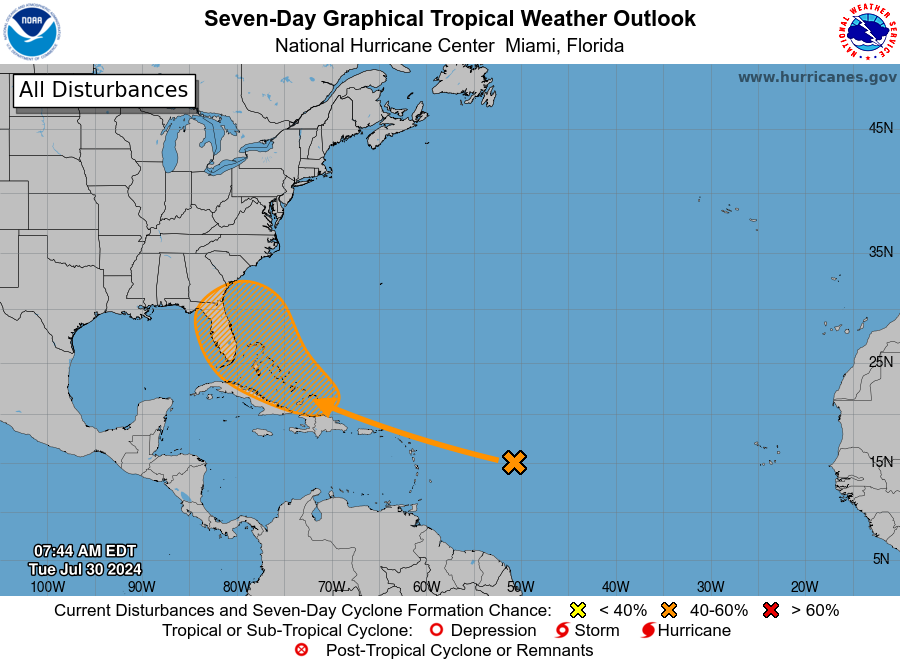
The National Hurricane Center has been tracking the tropical wave, which is a series of low-pressure areas, over the past few days. The wave has a 60% chance of development over the next seven days, and NHC forecasters say it could form into a tropical depression late this week.
Life of a hurricane: What's the difference between a tropical disturbance and storm? Here's what to know
"The tropical wave is currently battling a harsh environment in a sea of dry air as it moves west across the Atlantic," AccuWeather lead Hurricane expert Alex DaSilva said. "The dry air is working to keep the wave from gaining any organization."
"Toward the end of this week, the wave will move into an area with fairly low shear and ample moisture, and that could allow some organization and strengthening," DaSilva added.
Aiding in the wave's development is a cloudy area of disturbed areas along its predicted path. The two are expected to interact and collide, where they will "re-form as a single tropical rainstorm," according to AccuWeather.
Where is the tropical wave now?
The tropical wave is still a way out at the moment. It is currently centered several hundred miles east of the Lesser Antilles.
Will the tropical storm hit Florida?
It is, of course, too early to make a prediction with any degree of certainty. DaSilva has a few educated guesses, however.
"A major caveat is where the tropical rainstorm tracks," he said. "If it tracks north [or south] of the Greater Antilles, then it will have a better chance to develop as it will be removed from the towering mountains of Puerto Rico, Hispaniola and Cuba."
The high mountains of the Greater Antilles could aid in squashing wind flow, which would make it difficult for the storm to organize, according to AccuWeather.
If the center of the storm avoids the islands, the area's warm waters would fuel the storm, allowing it to strengthen further.
Depending on whether the storm tracks north or south of the big islands this week will be a key indicator in determining whether the storm could impact the East Coast or the Gulf Coast of the U.S., respectively.
Why Gulf Coast residents should keep an eye on the tropical wave
A large, high pressure area over the central Atlantic will play a role in where the tropical wave moves. AccuWeather says that pressure will push the storm west for a time. By this weekend or early next week, steering winds are expected to turn the storm to the northwest or north near the U.S.
Even if the storm does not head directly toward the Gulf Coast, the storm’s activity would begin churning waters in the Gulf, resulting in a “marked increase in the strength and frequency of rip currents,” according to AccuWeather.
What’s a tropical disturbance?
Tropical disturbances are basically a cluster of thunderstorm clouds. The clouds begin to release heat, columns of warm air begin to form as the air rises, and these columns continue to grow higher and bigger. As air pressure begins to shift, a creating a whirlpool effect.
What’s a tropical depression?
A tropical depression is the next step of the process and this is when we begin to see stronger winds. This is caused by those columns of air continuing to become stronger and larger.
When the warm vapor rises to the top of the clouds and cools down, the heat it once held has to go somewhere. In this case, that heat energy is released into the air at the top of the clouds, which makes the air pressure higher. That pressure begins pushing out into the surrounding areas of low pressure, creating those stronger winds and what is essentially a loop that creates more thunderstorms.
What is a tropical cyclone?
A tropical storm becomes a tropical cyclone, or a hurricane, once sustained wind speeds reach 74 mph. At this point, the storm is massive. According to NOAA, hurricanes are at least 50,000 feet high and 125 miles across. The eye alone can range between 5 and 30 miles wide.
From here, when a hurricane continues to strengthen, meteorologists refer to the Saffir-Simpson Hurricane Wind Scale.
This article originally appeared on Pensacola News Journal: Tropical wave has increased chance to become Tropical Storm Debby

