Tropical Storm Alberto is first named storm of the 2024 hurricane season | NHC
The tropical disturbance south of Texas in the Gulf of Mexico has intensified into the first tropical storm of the 2024 Atlantic hurricane season.
Alberto is expected to make landfall in Mexico early Thursday morning. Already, the storm has brought significant rainfall to Texas. Those in South Texas and along the coast can expect to see continuing impact, which will include flooding rain, coastal flooding, gusty winds and high surf and rip currents, through Thursday.
The storm is expected to produce rainfall totals of 5 to 10 inches across northeast Mexico into South Texas, with maximum totals of 15 inches possible, according to the National Hurricane Center.
NHC issued a tropical storm warning for several areas along Coastal Texas early Tuesday morning before expanding the warning to include a broader range of Texas in the afternoon. The warning now stretches across nearly the entirety of the state's coastline from San Luis Pass near Galveston to the mouth of the Rio Grande.
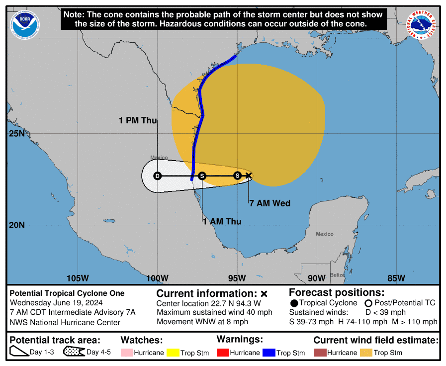
Where is Tropical Storm Alberto?
NHC warned that the system is very large, with tropical-storm-force winds extending outward up to 415 miles to the north of the center, increasing significantly from an advisory Tuesday morning that cited 290 miles outward.
Location: 295 miles southeast of Brownsville, Texas
Maximum sustained winds: 40 mph
Movement: west at 9 mph
Pressure: 995 MB
When will Tropical Storm Alberto make landfall in Mexico?
The center of the storm will reach the coast of northeastern Mexico early Thursday morning, the NHC said.
Watches and warnings in Texas
NHC has issued a tropical storm warning for the Texas coast from San Luis Pass southward to the mouth of the Rio Grande. A warning was also issued for the northeastern coast of Mexico south of the mouth of the Rio Grande to Tecolutla.
Track Tropical Storm Alberto
Key messages from the National Hurricane Center: What you need to know about Tropical Storm Alberto
Users are reminded not to focus on the exact forecast track of this system. The disturbance is very large with rainfall, coastal flooding, and wind impacts likely to occur far from the center along the coasts of Texas and northeastern Mexico.
Rainfall associated with Alberto will impact large regions of Central America, northeastern Mexico and South Texas. This rainfall will likely produce considerable flash and urban flooding along with new and renewed river flooding. Mudslides are also possible in areas of higher terrain across Central America into northeast Mexico.
Moderate coastal flooding is likely along much of the Texas Coast beginning Tuesday morning and continuing through midweek.
Tropical storm conditions are expected beginning Wednesday over portions of the Texas coast south of Port O’Connor, where a Tropical Storm Warning is in effect, and over portions of northeastern Mexico.
What impact could Alberto have and what areas could be affected?
Storm surge: The combination of a dangerous storm surge and the tide will cause normally dry areas near the coast to be flooded by rising waters moving inland from the shoreline. The water could reach the following heights above ground somewhere in the indicated areas if the peak surge occurs at the time of high tide:
Sargent, Texas, to Sabine Pass, Texas: 2-4 feet
Galveston Bay: 2-4 feet
Mouth of the Rio Grande, Texas, to Sargent, Texas: 1-3 feet
Sabine Pass, Texas, to Vermilion/Cameron Parish Line, Louisiana: 1-3 feet
The deepest water will occur along the immediate coast near and to the north of the landfall location, where the surge will be accompanied by large and dangerous waves. Surge-related flooding depends on the relative timing of the surge and the tidal cycle, and can vary greatly over short distances.
Rainfall: Tropical Storm Alberto is expected to produce rainfall totals of 5 to 10 inches across northeast Mexico into South Texas, with maximum totals of 15 inches possible. This rainfall will likely produce flash and urban flooding along with new and renewed river flooding. Mudslides are also possible in areas of higher terrain across northeast Mexico.
Wind: Tropical storm conditions are expected within the warning area by Wednesday.
Tornadoes: A couple of tornadoes may occur Wednesday across parts of Deep South into southeast Texas.
Surf: Swells generated by the disturbance will affect the coast of Texas and northeastern Mexico through early Thursday. These swells are likely to cause life-threatening surf and rip current conditions. Please consult products from your local weather office.
What do tropical storm watches, warnings from NHC mean?
What is storm surge? Graphics explain the deadly weather event
Tropical storm warning: A tropical storm warning means that tropical storm conditions are expected somewhere within the warning area within 36 hours.
Tropical storm watch: An announcement that sustained winds of 39 to 73 mph are possible within the specified area within 48 hours in association with a tropical, subtropical, or post-tropical cyclone.
— USA TODAY NETWORK - Florida reporter Cheryl McCloud contributed to this report.
This article originally appeared on Lubbock Avalanche-Journal: Tropical Storm Alberto tracker: Severe flooding threatens Texas

