National Hurricane Center: No tropical activity expected Sunday, Memorial Day
The Gulf of Mexico, North Atlantic and the Caribbean are expected to remain calm over the rest of the Memorial Day weekend, according to the outlook from the National Hurricane Center.
No tropical cyclone is expected for the next two days, the NHC said.
Hurricane season starts June 1 and is expected to be busy. Extremely warm water temperatures and La Niña combine for favorable tropical cyclone conditions.
Colorado State University has predicted the probability of a named storm impacting Florida this season at 96%, hurricane impact at 75% and major hurricane impact at 44%.
WeatherTiger chief meteorologist Ryan Truchelut's hurricane season forecast includes:
22-26 tropical storms
10-13 hurricanes
5-8 major hurricanes, which is a Category 3 storm or higher
an 80% chance of at least two U.S. hurricane landfalls in 2024
The first named storm of the Atlantic hurricane season will be named Alberto.
Memorial Day weekend weather forecast for Florida
Hot and mostly dry conditions are expected in Florida on Sunday and Monday. Above-normal temperatures may have some areas see heat indexes soaring to 107 degrees. A cold front is expected to move into North Florida and the Panhandle Monday.
Here's the latest update from the NHC as of 8 a.m., May 25, 2024:
What is out there and how likely are they to strengthen?
Here's NHC's outlook Sunday, based on satellite imagery, weather observations, radar and meteorological analysis:
Tropical wave: A tropical wave is along 63W, south of 16N, moving westward at 10 to 15 knots. Scattered moderate isolated strong convection is from 11N to 18N between 57W and 65W. The tropical wave will move through the eastern Caribbean Sea today, the central basin on Monday and the W Caribbean Tuesday. Showers are likely for Puerto Rico and the Virgin Islands tonight into Wednesday.
Gulf of Mexico: Weak surface ridging will continue to extend from the western Atlantic across the E Gulf into the upcoming week. This will maintain a weak pressure pattern over the basin. Mostly moderate to fresh SE to S winds will exist W of 87W through early Mon while light to gentle SE to S winds will exist E of 87W. The winds W of 87W will shift to W of 90W afterwards while winds east of 87W generally become light and variable, except S of 26N where they become gentle NE winds. Seas will be slight to moderate during the period. A cold front is expected to move across the NE Gulf Tuesday through Wednesday, followed by gentle to moderate W to NW winds. Fresh to strong winds will pulse near the northern and western Yucatan Peninsula during the late afternoons and at night through the period.
Caribbean Sea: High pressure over the western Atlantic will maintain moderate to locally fresh trade winds across the basin, except for pulsing fresh to strong winds in the Gulf of Honduras at night through Monday night. Moderate to fresh trade winds over the central Caribbean are forecast to increase to fresh to strong speeds late Monday night through late Tuesday night, then shifting to between 75W and 80W for the rest of the forecast period. The tropical wave will bring scattered to numerous showers and thunderstorms to the E Caribbean waters through Monday. Strong gusty winds and rough seas are likely with this activity. The wave may lose definition as moves across the central Caribbean during mid week. Dense smoke due to agricultural fires in Central America is likely to change over the Gulf of Honduras into the early part of the upcoming week.
Atlantic Ocean: A low will continue to move generally ENE through this evening as it weakens further with a trailing trough. Otherwise, relatively weak high pressure will remain over the region for the next few days. The associated gradient will support moderate winds and seas N of the Bahamas and off NE Florida by Monday night as the high pressure shifts eastward ahead of a weakening cold front that is expected to move across the waters N of the Bahamas Tuesday through Wednesday. Scattered showers and thunderstorms may accompany the front.
2024 hurricane season: Forecasts all point to a busy season with La Niña and warm ocean temps
Weather watches and warnings issued in Florida
When is the Atlantic hurricane season?
The Atlantic hurricane season runs from June 1 through Nov. 30.
When is the peak of hurricane season?
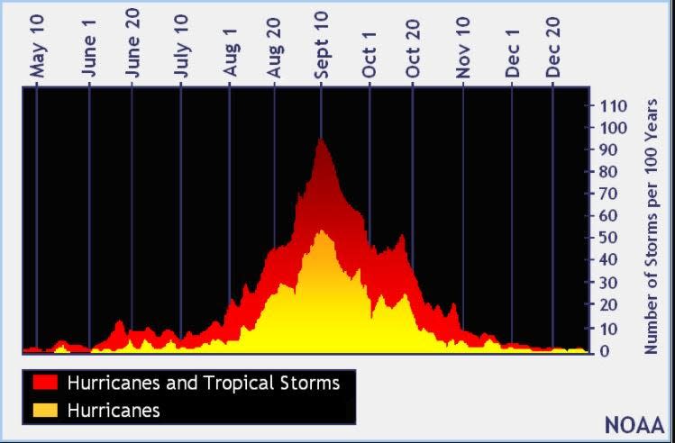
The peak of the season is Sept. 10, with the most activity happening between mid-August and mid-October, according to the Hurricane Center.
National Hurricane Center map: What are forecasters watching now?
Systems currently being monitored by the National Hurricane Center include:

Noaa
Embedded content: https://www.nhc.noaa.gov/xgtwo/two_atl_0d0.png?052051
Excessive rainfall forecast
What's next?
We will continue to update our tropical weather coverage daily. Download your local site's app to ensure you're always connected to the news. And look for our special subscription offers here.
This article originally appeared on Fort Myers News-Press: NHC: Tropics calm Sunday as 2024 hurricane season looms

