National Hurricane Center tracking Beryl after landfall, 3 tropical waves
Hurricane Beryl is heading north after making landfall near Matagorda, Texas, Monday morning as a Category 1 storm with 80-mph winds.
As expected, Beryl strengthened as it approached the coast, according to the National Hurricane Center.
➤ Live updates: Get the latest on Hurricane Beryl after its Texas landfall
While Beryl is expected to weaken into a tropical storm by the time it reaches the northwestern border of Louisiana early Tuesday morning, impacts will continue to be felt across the Midwest.
Heavy rainfall of 3 to 5 inches, with locally higher amounts possible, is expected across portions of far southeastern Oklahoma, Arkansas and southern Missouri tonight into Tuesday, Hurricane forecasters said.
Elsewhere, the National Hurricane Center is monitoring three tropical waves.
The next storm of the season will be Debby.
Here's the latest update from the NHC as of 8 a.m. July 8:
Hurricane Beryl weakens slightly after landfall near Matagorda, Texas

Could Hurricane Beryl affect Florida, US Gulf Coast?
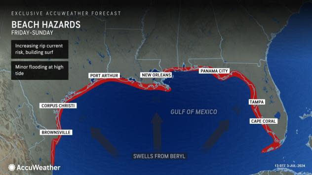
There is a high risk for dangerous rip currents and life-threatening surf along the Gulf Coast, according to the National Hurricane Center.
What else is NHC tracking in Atlantic basin?
Tropical wave 1: An eastern Atlantic tropical wave is moving westward at 11 to 17 mph.
Tropical wave 2: A central Atlantic tropical wave is moving westward at 11 to 17 mph.
Tropical wave 3: A tropical wave extends over the Yucatan Peninsula and is moving westward at 11 mph.
Who is likely to be impacted?
Hurricane Beryl: There is a high risk for dangerous rip currents and life-threatening beach conditions along the Gulf Coast, according to the National Hurricane Center.
Life-threatening storm surge, damaging winds, flooding and rainfall are spreading across southeastern Texas.
Heavy rainfall of 5 to 10 inches with localized amounts of 15 inches is expected across portions of the middle and upper Texas Gulf Coast and eastern Texas today into tonight. Considerable flash and urban flooding as well as minor to isolated major river flooding is expected. Heavy rainfall of 3 to 5 inches, with locally higher amounts possible, is expected across portions of far southeastern Oklahoma, Arkansas and southern Missouri tonight into Tuesday.
Forecasters urge all residents to continue monitoring the tropics and to always be prepared. That advice is particularly important for what is expected to be a very active hurricane season.
Weather watches and warnings issued in Florida
When is the Atlantic hurricane season?
The Atlantic hurricane season runs from June 1 through Nov. 30.
When is the peak of hurricane season?
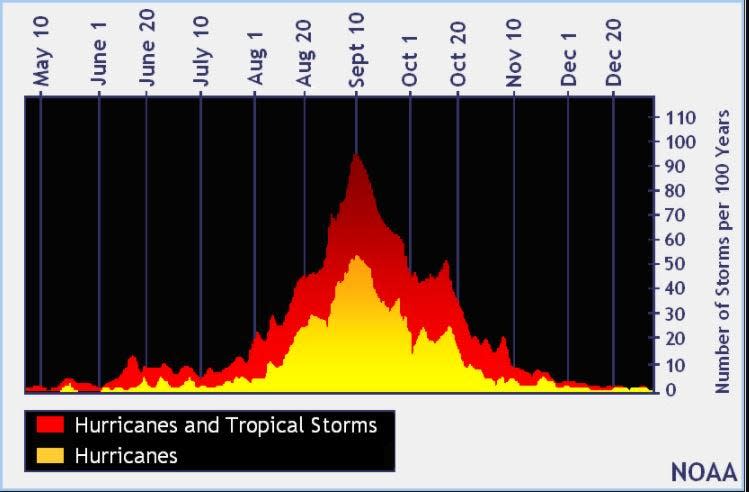
The peak of the season is Sept. 10, with the most activity happening between mid-August and mid-October, according to the Hurricane Center.
National Hurricane Center map: What are forecasters watching now?
Systems currently being monitored by the National Hurricane Center include:

Interactive map: Hurricanes, tropical storms that have passed near your city
Excessive rainfall forecast
What's next?
We will continue to update our tropical weather coverage daily. Download your local site's app to ensure you're always connected to the news. And look for our special subscription offers here.
This article originally appeared on Treasure Coast Newspapers: NHC tracking Hurricane Beryl, 3 tropical waves in Atlantic, Caribbean

