National Hurricane Center tracking Hurricane Beryl, Invest 96L. See latest forecast paths
The National Hurricane Center is tracking two systems in the Atlantic basin: Hurricane Beryl and Invest 96L.
Beryl, which made landfall about 11 a.m. EDT Monday, July 1, on Carriacou Island with 150-mph winds, strengthened overnight and is maintaining sustained winds of 165 mph.
Forecasters said Beryl is expected to bring "life-threatening winds and storm surge to Jamaica" on Wednesday.
Invest 96L remains in the Central Atlantic and currently has a low chance for development as it moves west toward the Caribbean.
AccuWeather hurricane experts said they expected the U.S. will avoid direct impacts from the Beryl but residents "should not let their guard down."
"At this point, the most likely scenario is for the storm to move westward into Mexico; however, it is very important to note that if the high pressure across the Southeast weakens, that can allow the storm to move farther north and potentially directly impact the Gulf Coast," said AccuWeather Lead Hurricane Forecaster Alex DaSilva.
The next storm of the season will be Debby.
2024 Atlantic hurricane season expected to be supercharged
Every forecast for the 2024 Atlantic hurricane season is predicting an above-normal season. The average number of named storms in a season is 14. AccuWeather forecasters have gone as far as saying 2024 could break the record of 30 named storms.
The presence of La Niña is a big factor in why every forecasting agency has been predicting a very active Atlantic hurricane season this year.
It doesn't help we're seeing record warm water temperatures in the Atlantic, which also provide fuel for tropical cyclones.
NOAA said May 2024 was the 14th consecutive month of record-warm global ocean temperatures.
Here's the latest update from the NHC as of 8 a.m. July 2:
Hurricane Beryl powerful Category 5 storm with 165-mph winds

Invest 96L now has low chance for development

Invest 96L: A tropical wave located about 1,000 miles east-southeast of the Windward Islands is producing limited shower and thunderstorm activity.
➤ Track 96L: Spaghetti models for Invest 96L
Environmental conditions are only marginally conducive for development of this system while it moves generally westward at 15 to 20 mph across the western tropical Atlantic and eastern Caribbean Sea.
Residents in the Lesser Antilles should still monitor the progress of this system, with heavy rainfall possible midweek.
Formation chance through 48 hours: low, 20 percent.
Formation chance through 7 days: low, 30 percent.
Who is likely to be impacted?
Hurricane Beryl: Forecasters said Beryl is expected to bring "life-threatening winds and storm surge to Jamaica later this week." Later in the week, the most likely scenario is for the storm to move westward into Mexico. But there is a potential for Beryl to turn more to the northwest upon reaching the northwestern Caribbean, so residents in the U.S., especially the Texas coast, should closely monitor the hurricane's progress and forecasts by meteorologists.

Invest 96L: It's still too early to tell whether this system will impact the U.S.
Forecasters urge all residents to continue monitoring the tropics and to always be prepared. That advice is particularly important for what is expected to be a very active hurricane season.
Weather watches and warnings issued in Florida
When is the Atlantic hurricane season?
The Atlantic hurricane season runs from June 1 through Nov. 30.
When is the peak of hurricane season?
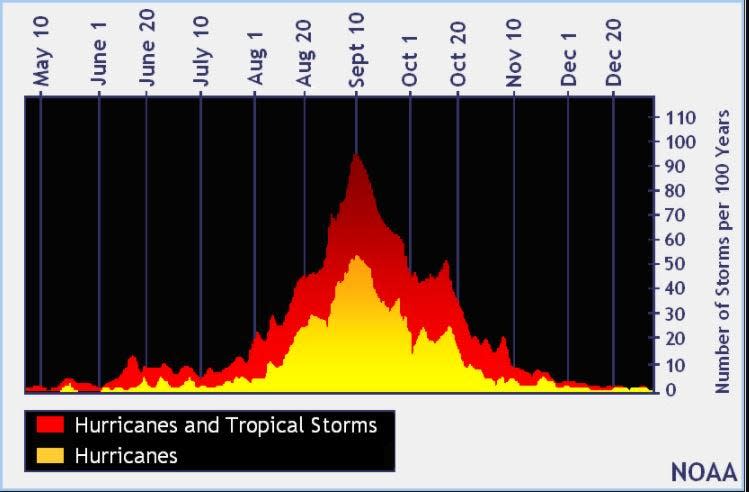
The peak of the season is Sept. 10, with the most activity happening between mid-August and mid-October, according to the Hurricane Center.
National Hurricane Center map: What are forecasters watching now?
Systems currently being monitored by the National Hurricane Center include:

Interactive map: Hurricanes, tropical storms that have passed near your city
Excessive rainfall forecast
What's next?
We will continue to update our tropical weather coverage daily. Download your local site's app to ensure you're always connected to the news. And look for our special subscription offers here.
This article originally appeared on Treasure Coast Newspapers: See Hurricane Beryl path, track Invest 96L. See spaghetti models

