National Hurricane Center tracking Hurricane Beryl, Invest 96L, 2 other tropical waves
The National Hurricane Center continues to track two systems in the Atlantic basin: Hurricane Beryl and Invest 96L.
Beryl, which first made landfall about 11 a.m. EDT Monday, July 1, on Carriacou Island, Grenada, with 150-mph winds, is now expected to pass over or near Jamaica later today. After becoming a Category 5 hurricane Monday with 165-mph winds, Beryl is now a Category 4 storm with 145-mph winds.
The hurricane is expected to bring devastating hurricane-force winds, life-threatening storm surge, and damaging waves to portions of Jamaica today and to the Cayman Islands tonight and into Thursday.
Elsewhere in the tropics, forecasters continue to track Invest 96L, which as of Wednesday morning was approaching the Windward Islands. It has a low chance for development through the next seven days.
There also are two tropical waves out there forecasters are monitoring: one in the eastern Atlantic west of the Cabo Verde Islands and one in the western Caribbean.
The next storm of the season will be Debby.
Here's the latest update from the NHC as of 8 a.m. July 3:
Hurricane Beryl taking aim at Jamaica as Category 4 storm

Could Hurricane Beryl affect Florida, US Gulf Coast?

Where Beryl will go once it reaches the Gulf of Mexico, and how strong it will be when it gets there, remain uncertain.
AccuWeather meteorologists have given the Atlantic coast of the U.S. and the Florida Peninsula the all-clear from direct impacts from Beryl, AccuWeather Chief Meteorologist Jonathan Porter said, but that is not the case for portions of the Gulf Coast.
"From Panama City, to New Orleans, there is a low risk of direct impacts from Beryl, but from about Corpus Christi to Brownsville, Texas, the risk increases significantly due to the potential for Beryl to have more direct impacts," Porter said.
"That southern portion of the Texas coast is the zone we have to really watch."
Invest 96L approaching Windward Islands with low chance for development

Invest 96L: Shower and thunderstorm activity remains disorganized in association with a tropical wave located a couple of hundred miles east of the Windward Islands.
➤ Track 96L: Spaghetti models for Invest 96L
Development, if any, of this system should be slow to occur while it moves quickly westward to west-northwestward at 20 to 25 mph across the Caribbean Sea.
Regardless of development, gusty winds and locally heavy rainfall are possible across portions of the Lesser Antilles today.
Formation chance through 48 hours: low, 10 percent.
Formation chance through 7 days: low, 20 percent.
Who is likely to be impacted?
Hurricane Beryl: Devastating hurricane-force winds, life-threatening storm surge, and damaging waves are expected on portions of Jamaica beginning this afternoon and in the Cayman Islands early on Thursday. Life-threatening flash flooding and mudslides from heavy rainfall are expected over much of Jamaica and southern Haiti through today.
Invest 96L: It's still too early to tell whether this system will impact the U.S.
Forecasters urge all residents to continue monitoring the tropics and to always be prepared. That advice is particularly important for what is expected to be a very active hurricane season.
Weather watches and warnings issued in Florida
When is the Atlantic hurricane season?
The Atlantic hurricane season runs from June 1 through Nov. 30.
When is the peak of hurricane season?
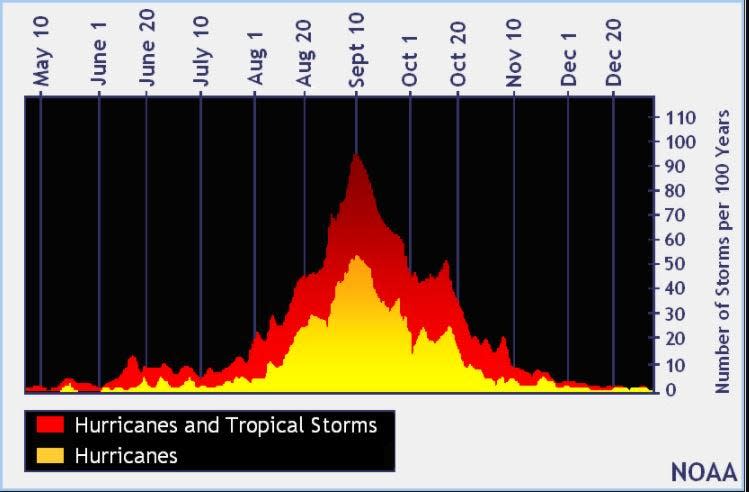
The peak of the season is Sept. 10, with the most activity happening between mid-August and mid-October, according to the Hurricane Center.
National Hurricane Center map: What are forecasters watching now?
Systems currently being monitored by the National Hurricane Center include:

Interactive map: Hurricanes, tropical storms that have passed near your city
Excessive rainfall forecast
What's next?
We will continue to update our tropical weather coverage daily. Download your local site's app to ensure you're always connected to the news. And look for our special subscription offers here.
This article originally appeared on Treasure Coast Newspapers: NHC tracking Hurricane Beryl, Invest96L, 2 tropical waves. Forecast path

