National Hurricane Center tracking Hurricane Beryl, 2 tropical waves
Hurricane Beryl made its second landfall Friday morning on the Yucatan Peninsula near Tulum, Mexico, according to the latest advisory from the National Hurricane Center.
While it's expected to weaken as it moves over land, it's forecast to strengthen again once it reaches the Gulf of Mexico.
Where it goes after that and how strong it will get remain uncertain.
What forecasters are confident about is that life-threatening surf and dangerous rip currents are expected along the entire Gulf Coast into the holiday weekend.
It was the second landfall for Beryl. Four days ago, on July 1, it made its first landfall at 11 a.m. on Carriacou Island, Grenada, as a Category 4 storm with 150-mph winds.
Elsewhere, the National Hurricane Center is taking note of two tropical waves..
The next storm of the season will be Debby.
Here's the latest update from the NHC as of 8 a.m. July 5:
Hurricane Beryl makes landfall along Mexico coast as Category 2 storm

Could Hurricane Beryl affect Florida, US Gulf Coast?
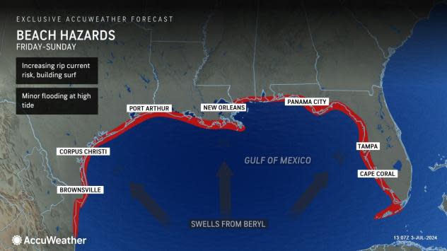
There is a high risk for dangerous rip currents and life-threatening surf along the Gulf Coast, according to the National Hurricane Center.
Expect conditions to deteriorate Friday evening and remain high over the holiday weekend as swells from Hurricane Beryl arrive along area beaches, said the National Weather Service Tallahassee.
What else is NHC tracking in Atlantic basin?

Tropical wave 1: A tropical wave in the central Atlantic is moving west at 11-17 mph. It's embedded in dry Saharan dust, which is suppressing development.
Tropical wave 2: Another tropical wave in the Central Caribbean is moving west at 23 mph.
Who is likely to be impacted?
Hurricane Beryl: There is a high risk for dangerous rip currents and life-threatening beach conditions along the Gulf Coast, according to the National Hurricane Center.
There is an increasing risk of strong winds, storm surge, and heavy rainfall in portions of northeastern Mexico and southern Texas late this weekend
Forecasters urge all residents to continue monitoring the tropics and to always be prepared. That advice is particularly important for what is expected to be a very active hurricane season.
Weather watches and warnings issued in Florida
When is the Atlantic hurricane season?
The Atlantic hurricane season runs from June 1 through Nov. 30.
When is the peak of hurricane season?
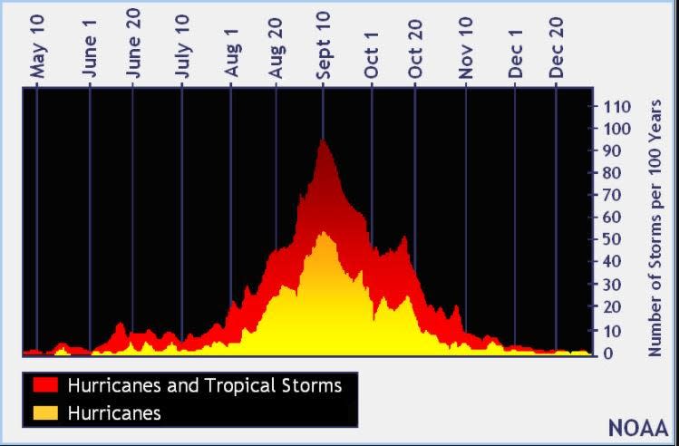
The peak of the season is Sept. 10, with the most activity happening between mid-August and mid-October, according to the Hurricane Center.
National Hurricane Center map: What are forecasters watching now?
Systems currently being monitored by the National Hurricane Center include:

Interactive map: Hurricanes, tropical storms that have passed near your city
Excessive rainfall forecast
What's next?
We will continue to update our tropical weather coverage daily. Download your local site's app to ensure you're always connected to the news. And look for our special subscription offers here.
This article originally appeared on Treasure Coast Newspapers: NHC tracking Hurricane Beryl, 2 tropical waves

