Hurricane Beryl weakens to Category 2. National Hurricane Center also watching Invest 96L
Hurricane Beryl is moving toward the Yucatan Peninsula as a Category 2 storm after pounding the Cayman Islands, while a fast-moving tropical wave was located over the Eastern Caribbean Sea Thursday morning, according to the National Hurricane Center.
Beryl lashed the southern coast of Jamaica Wednesday as a Category 4 hurricane with 140-mph winds.
Beryl has weakened to a Category 2 hurricane with 110 mph winds. While weakening is forecast, it is still expected to be a hurricane when it hits the Yucatan Peninsula early Friday.
The tropical wave, Invest 96L, was producing some disorganized shower and thunderstorm activity. Chances of development of this system are low through the next seven days.
The next storm of the season will be Debby.
Here's the latest update from the NHC as of 5 p.m. July 4:
Hurricane Beryl
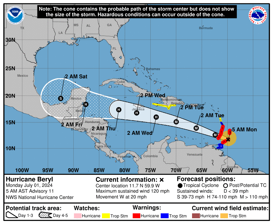
As of the National Hurricane Center's 5 p.m. advisory, the center of Hurricane Beryl was located near latitude 19.5 North, longitude 84.3 West.
Beryl is moving toward the west-northwest near 20 mph. A westward to west-northwestward motion is expected during the next day or two, with the center expected to make landfall over the Yucatan Peninsula of Mexico early Friday. Beryl is expected to emerge over the southwestern Gulf of Mexico Friday night and move northwestward across the southwestern Gulf on Saturday.
Maximum sustained winds are near 110 mph with higher gusts. Slow weakening is forecast before the center makes landfall, with additional weakening expected while Beryl crosses the Yucatan Peninsula. Slow re-intensification is expected when Beryl moves over the Gulf of Mexico.
Hurricane-force winds extend outward up to 30 miles from the center and tropical-storm-force winds extend outward up to 160 miles. The latest minimum central pressure estimated from Air Force Reserve Hurricane Hunter data is 974 mb.
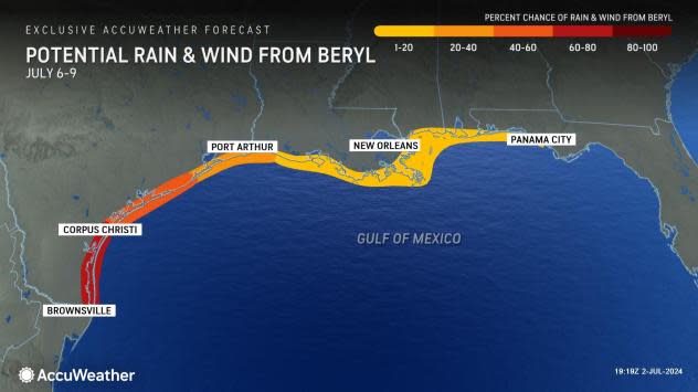
Could Hurricane Beryl affect Florida, US Gulf Coast?
Invest 96L
Invest 96L: A fast-moving tropical wave located over the eastern Caribbean Sea is producing some disorganized shower and thunderstorm activity.
Development, if any, of this system should be slow to occur while it moves quickly westward to west-northwestward at 20 to 25 mph across the Caribbean Sea during the next several days.
The system is forecast to cross the Yucatan Peninsula late this weekend and enter the southwestern Gulf of Mexico by early next week. Regardless of development, gusty winds and locally heavy rainfall are possible across portions of the Greater Antilles over the next few days.
➤ Track 96L: Spaghetti models for Invest 96L
Formation chance through 48 hours: near 0 percent.
Formation chance through 7 days: low, 10 percent.
Who is likely to be impacted?
Hurricane Beryl: The storm is growing more likely to affect northeastern Mexico and southern Texas later this weekend. Interests in those areas should monitor the progress of the storm.
Invest 96L: It's still too early to tell whether this system will impact the U.S.
Forecasters urge all residents to continue monitoring the tropics and to always be prepared. That advice is particularly important for what is expected to be a very active hurricane season.
Weather watches and warnings issued in Florida
When is the Atlantic hurricane season?
The Atlantic hurricane season runs from June 1 through Nov. 30.
When is the peak of hurricane season?
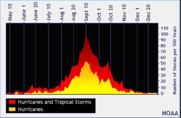
The peak of the season is Sept. 10, with the most activity happening between mid-August and mid-October, according to the Hurricane Center.
National Hurricane Center map: What are forecasters watching now?
Systems currently being monitored by the National Hurricane Center include:
Interactive map: Hurricanes, tropical storms that have passed near your city
Excessive rainfall forecast
What's next?
We will continue to update our tropical weather coverage daily. Download your local site's app to ensure you're always connected to the news. And look for our special subscription offers here.
This article originally appeared on Treasure Coast Newspapers: NOAA hurricane tracker: Hurricane Beryl, Invest 96L forecast path

