National Hurricane Center issues tropical storm watch for Texas, tracks system east of Florida
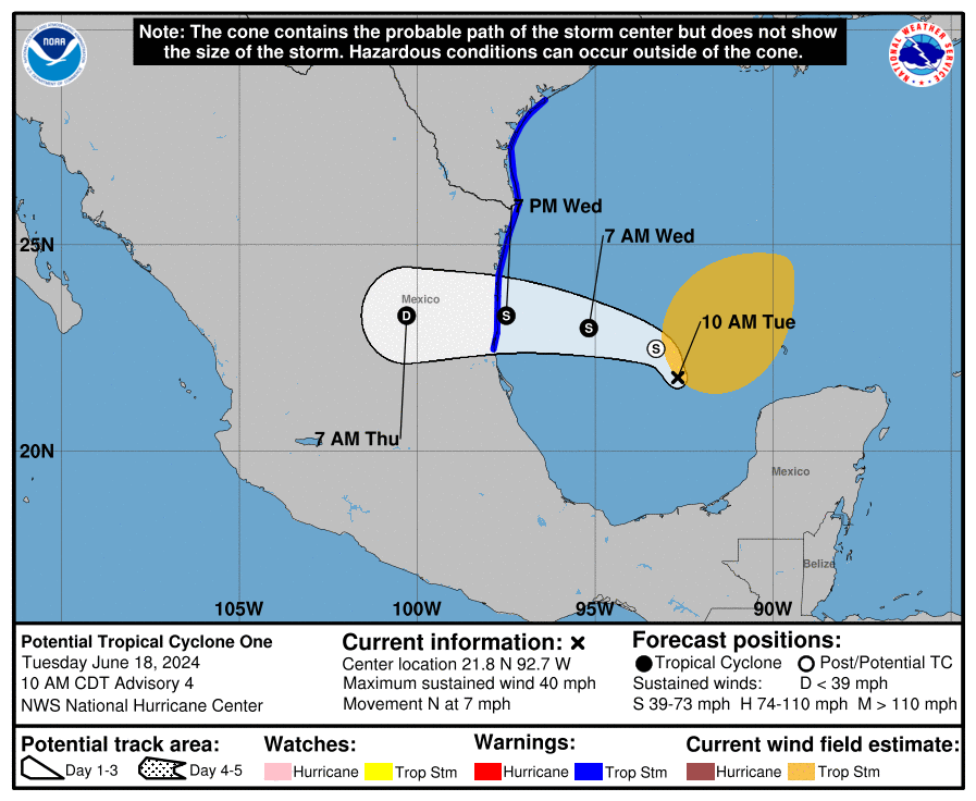
The National Hurricane Center issued an advisory for Potential Tropical Cyclone One Monday afternoon, the first such advisory of the 2024 Atlantic hurricane season.
A tropical storm watch is in effect for the Texas coast, from Port O'Connor southward to the mouth of theRio Grande, with additional watches and warnings possible tonight and Tuesday.
A tropical storm watch means tropical storm conditions are possible within the watch area, generally within 48 hours.
Potential Tropical Cyclone One is very large with rainfall, coastal flooding and wind impacts likely to occur far from the center along the coasts of Texas and Mexico. Moderate coastal flooding is likely along much of the Texas coast beginning early Tuesday and through midweek, the NHC warned.
The system's maximum sustained winds were near 40 mph with higher gusts and the hurricane center has forecast it to become a tropical storm by Wednesday.
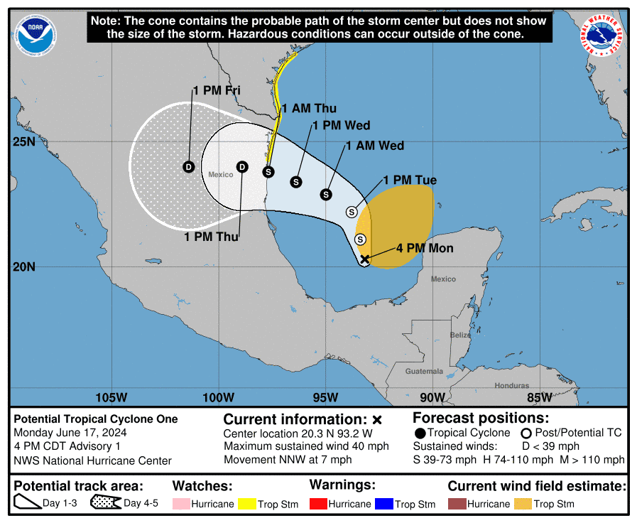
Residents along the western and northwestern Gulf coasts were advised to closely monitor the progress of this system, the Hurricane Center said.
The system could bring torrential rainfall to the area similar what South and Southwest Florida experienced last week. Some areas in Florida received almost two feet of rain from the slow-moving storm — Invest 90L — that crossed the state.
Another disturbance east of Florida also is showing potential for development as it moves closer to the U.S. It's expected to approach the southeast coast by Thursday or Friday.
The first named storm of the 2024 Atlantic hurricane season will be Alberto. To become a tropical storm, maximum sustained winds must reach at least 39 mph.
Here's the latest update from the NHC as of 5 p.m., June 17:
What is out there and how likely are they to strengthen?
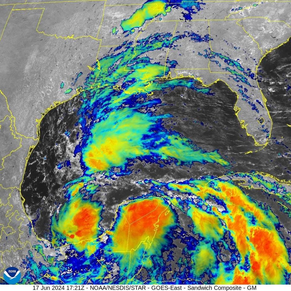
Gulf of Mexico: Satellite imagery and surface observations indicate that a broad area of low pressure is forming over the Bay of Campeche. This system is known as a Central American Gyre (CAG), and often persists for several days, with the threat to life and property increasing as the event continues. Environmental conditions appear conducive for additional gradual development, and a tropical depression or tropical storm is likely to form by midweek while it moves slowly westward or west-northwestward toward the western Gulf coast.
Regardless of development, several days of heavy rainfall are expected across portions of southern Mexico and Central America, and these rains are likely to cause life-threatening flooding and flash flooding. Locally heavy rainfall is also expected to spread over portions of the northwestern coast of the Gulf of Mexico by the middle of the week. In addition, gale warnings have been issued for portions of the Gulf of Mexico, and more information on those warnings is available in the High Seas Forecasts issued by the National Weather Service. Interests along the western and northwestern Gulf coasts should monitor the progress of this system. Increasing winds and building seas are expected. An Air Force Reserve Hurricane Hunter aircraft was scheduled to investigate the system on Monday.
Formation chance through 48 hours…high…80 percent.
Formation chance through 7 days…high…80 percent.
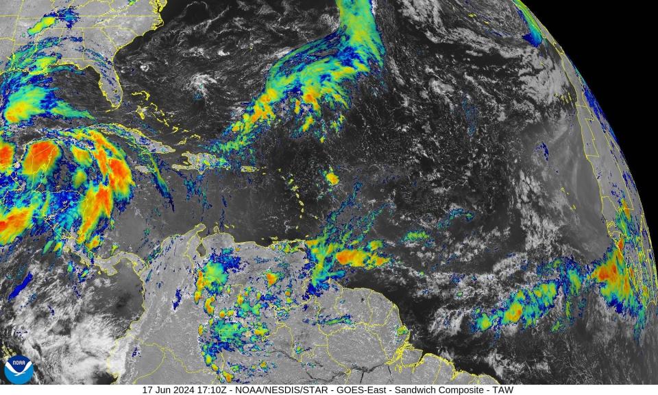
Southwestern Atlantic: An area of cloudiness and thunderstorms located several hundred miles east of the Bahamas is associated with a surface trough and an upper-level area of low pressure.
Environmental conditions could be conducive for some development of this system during the next few days while it moves west or west-northwest. The system is forecast to approach the coast of the southeast United States on Thursday or Friday.
Formation chance through 48 hours: low, 10 percent.
Formation chance through 7 days: low, 30 percent.
Who is likely to be impacted?
Two areas of active weather as ridiculous HEAT continues to build over the eastern 1/3rd of the USA. Midwest and northwestern Gulf coast will see heaviest rainfall. NHC up to 70% on at least a TD in the southwest GOM but its all about the HEAVY RAINFALL potential. The steering… pic.twitter.com/okA2Rx4LW2
— Jim Cantore (@JimCantore) June 17, 2024
Gulf of Mexico: Potential Tropical Cyclone One is expected to produce rainfall totals of 5 to 10 inches across northeast Mexico into southeastern Texas, with maximum totals of 15 inches possible. This rainfall will likely produce flash and urban flooding along with new and renewed river flooding. Mudslides are also possible in areas of higher terrain across northeast Mexico.
The combination of a dangerous storm surge and the tide will cause normally dry areas near the coast to be flooded by rising waters moving inland from the shoreline. The water could reach the following heights above ground somewhere in the indicated areas if the peak surge occurs at the time of high tide:
Sargent, TX to Sabine Pass, TX: 2-4 ft
Galveston Bay: 2-4 ft
Mouth of the Rio Grande, TX to Sargent, TX: 1-3 ft
Sabine Pass, TX to Vermilion/Cameron Parish Line, LA: 1-3 ft
The Weather Channel meteorologist Jim Cantore warned "double digit rainfall totals likely along the coastal counties of TX and potentially Houston."
"A tropical storm is likely to bring widespread gusts to the Mexican states of Tamaulipas and Nuevo Leon, as well as portions of South Texas," according to AccuWeather. "Some storm surge can also be expected along the coast north of the storm's landfall.
"Even if the tropical storm falls short of reaching tropical storm status, a plume of rich, deep tropical moisture is expected to surge into Mexico, Texas and Louisiana into the middle of the week," Pydynowski said. Heavy rain is forecast to extend well north of the center of the storm, beginning as early as Monday.
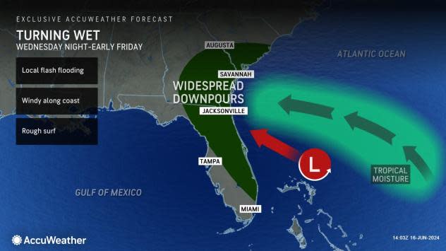
Atlantic: This system is forecast to approach the coast of the southeast United States on Thursday or Friday.
"This appears to be a quick-moving and compact low pressure area that will be moving westward into northeastern Florida or perhaps as far north as southeastern Georgia on Thursday," said Pydynowski.
A stronger storm could bring gusty winds, especially to coastal locations. Locations from Melbourne to Charleston, South Carolina, may be more at risk for the heavy rain. Rough surf and downpours are possible rom the northern Bahamas to the Southeast Atlantic Coast, according to AccuWeather.
Forecasters urge all residents to continue monitoring the tropics and to always be prepared. That advice is particularly important for what is expected to be a very active hurricane season.
Weather watches and warnings issued in Florida
When is the Atlantic hurricane season?
The Atlantic hurricane season runs from June 1 through Nov. 30.
When is the peak of hurricane season?
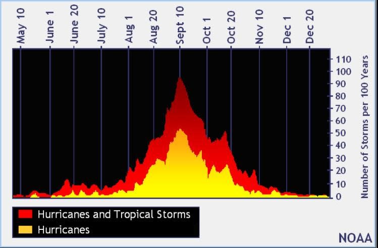
The peak of the season is Sept. 10, with the most activity happening between mid-August and mid-October, according to the Hurricane Center.
National Hurricane Center map: What are forecasters watching now?
Systems currently being monitored by the National Hurricane Center include:
Interactive map: Hurricanes, tropical storms that have passed near your city
Excessive rainfall forecast
What's next?
We will continue to update our tropical weather coverage daily. Download your local site's app to ensure you're always connected to the news. And look for our special subscription offers here.
This article originally appeared on Treasure Coast Newspapers: NHC issues tropical storm watch for TX coast. Will system impact FL?

